TopoQuest Logo
Do you find TopoQuest useful?
Help keep TopoQuest running and adding new maps/features by donating!
Bitcoin:  19c7KJd3qBynnjoSw5npx9KScwjBe4ifkT
Litecoin:  LXs6TkuXGGXo1vDsWCkWVdjQX94eUKd6ui
Home View Maps Find Maps Find Places Resources & Links


Manchester, North Carolina Topographic Map

USGS Map Title: Manchester, NC
USGS Map MRC: 35078B8
DRG (GeoTIFF) Download: o35078b8.tif


Neighboring USGS Topographic Map Quads:


  Olivia, NC  
35079C1
 

  Anderson Creek, NC  
35078C8
 

  Bunnlevel, NC  
35078C7
 

  Overhills, NC  
35079B1
 

  Manchester, NC  
35078B8
 

  Slocomb, NC  
35078B7
 

  Clifdale, NC  
35079A1
 

  Fayetteville, NC  
35078A8
 

  Vander, NC  
35078A7


Map MRC Location:

N36°
W79°
N36°
W78°
H8 H7 H6 H5 H4 H3 H2 H1
G8 G7 G6 G5 G4 G3 G2 G1
F8 F7 F6 F5 F4 F3 F2 F1
E8 E7 E6 E5 E4 E3 E2 E1
D8 D7 D6 D5 D4 D3 D2 D1
C8 C7 C6 C5 C4 C3 C2 C1
B8 B7 B6 B5 B4 B3 B2 B1
A8 A7 A6 A5 A4 A3 A2 A1
N35°
W79°
N35°
W78°

Manchester, NC USGS 1:24K Topographic Map Preview:
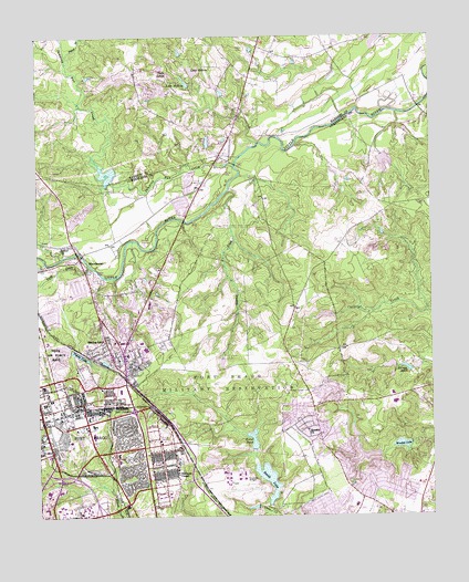
Manchester, NC USGS Topographic Map
Click on map above to begin viewing in our Map Viewer.

This topographic map contains these locations and features:
Feature Name Type Latitude Longitude GNIS ID View Map
Anzio AcresPopulated PlaceN35.1335°W78.9692°1005755View Map
ArdennesPopulated PlaceN35.1604°W78.9836°1005760View Map
Ascot IIPopulated PlaceN35.1432°W78.8775°1004941View Map
Bastogne GablesPopulated PlaceN35.1554°W78.9900°1005753View Map
BataanPopulated PlaceN35.1607°W78.9742°1005759View Map
Bethel ChurchChurchN35.1952°W78.9923°981122View Map
BougainvillePopulated PlaceN35.1446°W78.9714°1005757View Map
CasablancaPopulated PlaceN35.1374°W78.9706°1005756View Map
College LakeReservoirN35.1435°W78.8814°998436View Map
College Lake DamDamN35.1435°W78.8814°998435View Map
College Lakes Elementary SchoolSchoolN35.1279°W78.8989°1006524View Map
CorregidorPopulated PlaceN35.1491°W78.9720°1005758View Map
Eureka ChurchChurchN35.1474°W78.9145°984846View Map
Eureka SpringsPopulated PlaceN35.1496°W78.9092°1001122View Map
Fayetteville Fire Department Station 7BuildingN35.1314°W78.8851°2639053View Map
Fort Bragg Fire and Emergency Services HeadquartersBuildingN35.1408°W78.9800°2639601View Map
Fort Bragg Fire and Emergency Services Station 2BuildingN35.1365°W78.9393°2638714View Map
Fort Bragg Fire and Emergency Services Station 4BuildingN35.1550°W78.9742°2638705View Map
Fort Bragg Macomb Post OfficePost OfficeN35.1526°W78.9883°2774269View Map
Fort Bragg Main Post CemetaryCemeteryN35.1573°W78.9690°2773425View Map
Fort Bragg Post OfficePost OfficeN35.1304°W78.9959°2774268View Map
Fort JunctionLocaleN35.1527°W78.9695°985321View Map
Gibsons CreekStreamN35.2099°W78.9389°985673View Map
Holmes PondReservoirN35.1638°W78.8796°986975View Map
Howard L Hall Elementary SchoolSchoolN35.1691°W78.8967°1006525View Map
Jumping Run CreekStreamN35.2166°W78.9372°987823View Map
Lake HoltonReservoirN35.2411°W78.9499°986983View Map
Lake McKayReservoirN35.2381°W78.9520°989592View Map
Lewis LakeReservoirN35.2249°W78.8819°998624View Map
Lewis Lake DamDamN35.2268°W78.8831°998625View Map
Long Valley Farm LakeReservoirN35.2127°W78.9773°998582View Map
Long Valley Farm Lake DamDamN35.2118°W78.9764°998583View Map
ManchesterPopulated PlaceN35.1927°W78.9864°1021337View Map
Mitchells PondReservoirN35.2415°W78.9053°998649View Map
Mitchells Pond DamDamN35.2415°W78.9052°998650View Map
NC Noname One-Thousand Thirty-One DamDamN35.1402°W78.9431°998431View Map
Normandy HeightsPopulated PlaceN35.1452°W78.9920°1005754View Map
Pine Forest Senior High SchoolSchoolN35.1543°W78.8872°1006526View Map
Pistol BranchStreamN35.2454°W78.9898°992421View Map
Rakksan ChapelChurchN35.1360°W78.9556°992999View Map
Sandhills State Veterans CemeteryCemeteryN35.1589°W78.9709°2773424View Map
Simmons Army AirfieldAirportN35.1344°W78.9373°2679179View Map
Simmons LakeReservoirN35.1398°W78.9452°998432View Map
Smith LakeReservoirN35.1346°W78.9270°994987View Map
Smith Lake DamDamN35.1285°W78.9264°998415View Map
Spring LakePopulated PlaceN35.1679°W78.9728°1022752View Map
Spring Lake Fire DepartmentBuildingN35.1705°W78.9843°2638205View Map
Spring Lake Police DepartmentBuildingN35.1704°W78.9841°2769790View Map
Spring Lake Post OfficePost OfficeN35.1688°W78.9777°2774104View Map
Tank CreekStreamN35.1907°W78.9834°995839View Map
Texas LakeReservoirN35.1418°W78.9314°998434View Map
Texas PondReservoirN35.1451°W78.9317°995950View Map
Texas Pond DamDamN35.1418°W78.9314°998433View Map
Town of Spring LakeCivilN35.1841°W78.9962°2407386View Map
Twin LakesPopulated PlaceN35.2407°W78.9572°1023024View Map
WFBS-AM (Spring Lake)TowerN35.1835°W78.9622°1018406View Map
WoodbridgePopulated PlaceN35.1571°W78.8914°1001123View Map
Wooded LakeReservoirN35.1436°W78.8845°997580View Map
Young LakeReservoirN35.1673°W78.9866°997732View Map

Note: Coordinates in the location and feature list above are referenced to NAD83 datum.


Copyright (C) 2008-2025 Ryan Niemi / Sunset Dynamics ... All Rights Reserved