TopoQuest Logo
Do you find TopoQuest useful?
Help keep TopoQuest running and adding new maps/features by donating!
Bitcoin:  19c7KJd3qBynnjoSw5npx9KScwjBe4ifkT
Litecoin:  LXs6TkuXGGXo1vDsWCkWVdjQX94eUKd6ui
Home View Maps Find Maps Find Places Resources & Links


Omaha, Arkansas Topographic Map

USGS Map Title: Omaha, AR
USGS Map MRC: 36093D2
DRG (GeoTIFF) Download: o36093d2.tif


Neighboring USGS Topographic Map Quads:


  Table Rock Dam, MO  
36093E3
 

  Hollister, MO  
36093E2
 

  Mincy, MO  
36093E1
 

  Denver, AR  
36093D3
 

  Omaha, AR  
36093D2
 

  Omaha NE, AR  
36093D1
 

  Alpena, AR  
36093C3
 

  Batavia, AR  
36093C2
 

  Bergman, AR  
36093C1


Map MRC Location:

N37°
W94°
N37°
W93°
H8 H7 H6 H5 H4 H3 H2 H1
G8 G7 G6 G5 G4 G3 G2 G1
F8 F7 F6 F5 F4 F3 F2 F1
E8 E7 E6 E5 E4 E3 E2 E1
D8 D7 D6 D5 D4 D3 D2 D1
C8 C7 C6 C5 C4 C3 C2 C1
B8 B7 B6 B5 B4 B3 B2 B1
A8 A7 A6 A5 A4 A3 A2 A1
N36°
W94°
N36°
W93°

Omaha, AR USGS 1:24K Topographic Map Preview:
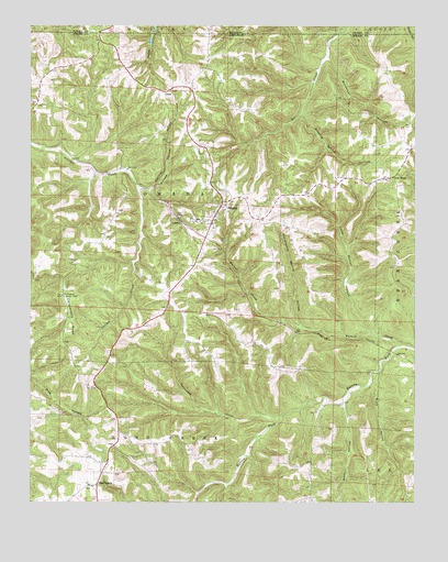
Omaha, AR USGS Topographic Map
Click on map above to begin viewing in our Map Viewer.

This topographic map contains these locations and features:
Feature Name Type Latitude Longitude GNIS ID View Map
Blowing Spring HollowValleyN36.4762°W93.1610°46735View Map
Buck HollowValleyN36.4059°W93.1374°47130View Map
Burchman HollowValleyN36.4915°W93.1538°47189View Map
BurlingtonPopulated PlaceN36.3795°W93.2282°76468View Map
Burlington Baptist ChurchChurchN36.3795°W93.2310°69264View Map
Burlington Lookout TowerTowerN36.4292°W93.2399°81985View Map
Cloverdale RidgeRidgeN36.4223°W93.2366°47863View Map
Cranenest CreekStreamN36.3973°W93.1682°48143View Map
CrestPopulated PlaceN36.4834°W93.2055°57607View Map
CricketPopulated PlaceN36.4490°W93.2024°56974View Map
Groverware Spring HollowValleyN36.4217°W93.1618°49694View Map
KHOZ-FM (Harrison)TowerN36.4365°W93.2455°85188View Map
Little Walnut CreekStreamN36.4190°W93.1388°51338View Map
New HopePopulated PlaceN36.4606°W93.1321°58257View Map
New Hope Baptist ChurchChurchN36.4598°W93.1335°69307View Map
OmahaPopulated PlaceN36.4523°W93.1885°58309View Map
Omaha Church of ChristChurchN36.4528°W93.1868°69313View Map
Omaha Elementary SchoolSchoolN36.4492°W93.1958°69314View Map
Omaha Fire DepartmentBuildingN36.4512°W93.1897°2116902View Map
Omaha High SchoolSchoolN36.4484°W93.1959°69315View Map
Omaha Middle SchoolSchoolN36.4494°W93.1953°2039020View Map
Pinrod HollowValleyN36.4567°W93.2110°53503View Map
Shaw LakeReservoirN36.4994°W93.2099°79616View Map
Shaw Lake DamDamN36.4984°W93.2118°79615View Map
Town of OmahaCivilN36.4583°W93.1909°2407047View Map
Township of Long CreekCivilN36.3799°W93.2208°69615View Map
Township of OmahaCivilN36.4561°W93.1723°69618View Map
Walnut CreekStreamN36.4165°W93.1296°55997View Map
Wolf HollowValleyN36.4006°W93.1480°56496View Map

Note: Coordinates in the location and feature list above are referenced to NAD83 datum.


Copyright (C) 2008-2024 Ryan Niemi / Sunset Dynamics ... All Rights Reserved