TopoQuest Logo
Do you find TopoQuest useful?
Help keep TopoQuest running and adding new maps/features by donating!
Bitcoin:  19c7KJd3qBynnjoSw5npx9KScwjBe4ifkT
Litecoin:  LXs6TkuXGGXo1vDsWCkWVdjQX94eUKd6ui
Home View Maps Find Maps Find Places Resources & Links


Oman Ranch, Washington Topographic Map

USGS Map Title: Oman Ranch, WA
USGS Map MRC: 46123D7
DRG (GeoTIFF) Download: o46123d7.tif


Neighboring USGS Topographic Map Quads:


  Nemah, WA  
46123E8
 

  North Nemah, WA  
46123E7
 

  Menlo, WA  
46123E6
 

  Long Island, WA  
46123D8
 

  Oman Ranch, WA  
46123D7
 

  Upper Naselle River, WA  
46123D6
 

  Chinook, WA  
46123C8
 

  Knappton, WA  
46123C7
 

  Rosburg, WA  
46123C6


Map MRC Location:

N47°
W124°
N47°
W123°
H8 H7 H6 H5 H4 H3 H2 H1
G8 G7 G6 G5 G4 G3 G2 G1
F8 F7 F6 F5 F4 F3 F2 F1
E8 E7 E6 E5 E4 E3 E2 E1
D8 D7 D6 D5 D4 D3 D2 D1
C8 C7 C6 C5 C4 C3 C2 C1
B8 B7 B6 B5 B4 B3 B2 B1
A8 A7 A6 A5 A4 A3 A2 A1
N46°
W124°
N46°
W123°

Oman Ranch, WA USGS 1:24K Topographic Map Preview:
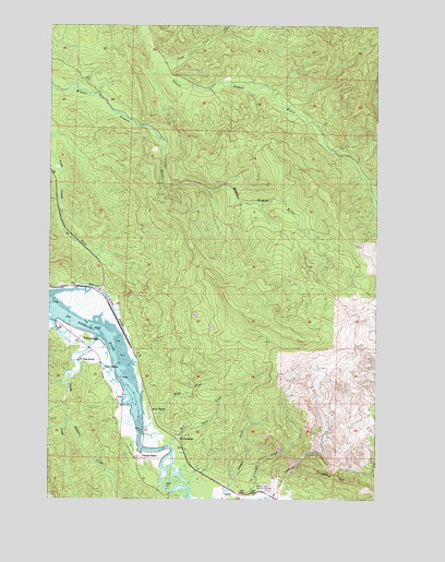
Oman Ranch, WA USGS Topographic Map
Click on map above to begin viewing in our Map Viewer.

This topographic map contains these locations and features:
Feature Name Type Latitude Longitude GNIS ID View Map
Cowan Peak LookoutLocaleN46.4170°W123.7810°1512929View Map
Elkhorn CreekStreamN46.3962°W123.8688°1504721View Map
Finn CreekStreamN46.4898°W123.8318°1504880View Map
Holm CreekStreamN46.3973°W123.8393°1505563View Map
Holm RanchLocaleN46.3982°W123.8368°1505564View Map
Johnsons LandingLocaleN46.4298°W123.8568°1512967View Map
Longfellow HillSummitN46.3815°W123.7701°1512401View Map
Naselle - Grays River Valley Elementary SchoolSchoolN46.3767°W123.8019°2606517View Map
Naselle Air Force Station (historical)MilitaryN46.4219°W123.7964°2089733View Map
Naselle QuarryMineN46.3849°W123.7835°2605700View Map
Naselle State Salmon HatcheryLocaleN46.3770°W123.7960°1533181View Map
Naselle SubstationLocaleN46.3763°W123.8056°2606880View Map
Naselle Youth Camp SchoolSchoolN46.3899°W123.8250°2606393View Map
Oman RanchLocaleN46.4093°W123.8552°1507184View Map
Parpala RanchLocaleN46.3859°W123.8421°1507311View Map
Petes CreekStreamN46.3887°W123.8299°1513185View Map
Ring RanchLocaleN46.4115°W123.8635°1507812View Map
Roaring Creek SloughGutN46.4248°W123.8510°1507828View Map
S Ring RanchLocaleN46.4170°W123.8627°1507974View Map
Silvola RanchLocaleN46.3909°W123.8263°1508355View Map
Smith CreekStreamN46.4176°W123.8577°1508424View Map
Wirkkala Dam Number OneDamN46.3798°W123.8063°1532895View Map
Wirkkala Dam Number TwoDamN46.3798°W123.8046°1532896View Map
Wirkkala PondsLakeN46.3806°W123.8056°1514787View Map

Note: Coordinates in the location and feature list above are referenced to NAD83 datum.


Copyright (C) 2008-2025 Ryan Niemi / Sunset Dynamics ... All Rights Reserved