TopoQuest Logo
Do you find TopoQuest useful?
Help keep TopoQuest running and adding new maps/features by donating!
Bitcoin:  19c7KJd3qBynnjoSw5npx9KScwjBe4ifkT
Litecoin:  LXs6TkuXGGXo1vDsWCkWVdjQX94eUKd6ui
Home View Maps Find Maps Find Places Resources & Links


Long Island, Washington Topographic Map

USGS Map Title: Long Island, WA
USGS Map MRC: 46123D8
DRG (GeoTIFF) Download: o46123d8.tif


Neighboring USGS Topographic Map Quads:


  Oysterville, WA  
46124E1
 

  Nemah, WA  
46123E8
 

  North Nemah, WA  
46123E7
 

  Ocean Park, WA  
46124D1
 

  Long Island, WA  
46123D8
 

  Oman Ranch, WA  
46123D7
 

  Cape Disappointment, WA  
46124C1
 

  Chinook, WA  
46123C8
 

  Knappton, WA  
46123C7


Map MRC Location:

N47°
W124°
N47°
W123°
H8 H7 H6 H5 H4 H3 H2 H1
G8 G7 G6 G5 G4 G3 G2 G1
F8 F7 F6 F5 F4 F3 F2 F1
E8 E7 E6 E5 E4 E3 E2 E1
D8 D7 D6 D5 D4 D3 D2 D1
C8 C7 C6 C5 C4 C3 C2 C1
B8 B7 B6 B5 B4 B3 B2 B1
A8 A7 A6 A5 A4 A3 A2 A1
N46°
W124°
N46°
W123°

Long Island, WA USGS 1:24K Topographic Map Preview:
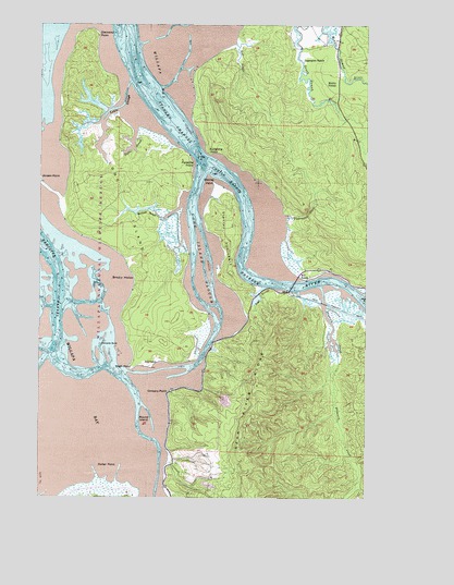
Long Island, WA USGS Topographic Map
Click on map above to begin viewing in our Map Viewer.

This topographic map contains these locations and features:
Feature Name Type Latitude Longitude GNIS ID View Map
Baldwin SloughStreamN46.4518°W123.9468°1503146View Map
Chetlo HarborBayN46.4590°W123.9288°1503948View Map
Clearwater CreekStreamN46.4490°W123.9063°1504013View Map
Diamond PointCapeN46.4970°W123.9807°1504473View Map
Ellsworth CreekStreamN46.4293°W123.8932°1504739View Map
Ellsworth SloughStreamN46.4290°W123.8932°1504740View Map
High PointCapeN46.4095°W123.9652°1505501View Map
Kaffee SloughStreamN46.4723°W123.9643°1505891View Map
Lagergren RanchLocaleN46.4898°W123.9004°1506046View Map
Lewis SloughStreamN46.4843°W123.9668°1506142View Map
Long IslandIslandN46.4520°W123.9688°1506279View Map
Long Island SloughStreamN46.4609°W123.9390°1506282View Map
Louse RocksIslandN46.4137°W123.9702°1514930View Map
Middle NemahPopulated PlaceN46.4837°W123.8871°1511148View Map
Mill RanchLocaleN46.4343°W123.8985°1509936View Map
Naselle RiverStreamN46.4651°W123.9399°1506929View Map
O'Meara PointCapeN46.4020°W123.9507°1507186View Map
Paradise PointCapeN46.4626°W123.9421°1507291View Map
Pinnacle RockPillarN46.4148°W123.9710°1507452View Map
Porter PointCapeN46.3795°W123.9774°1507590View Map
Reef RanchLocaleN46.4098°W123.9585°1507770View Map
Refuge Display Pool DamDamN46.4148°W123.9363°1532556View Map
Round IslandIslandN46.3943°W123.9602°1507931View Map
Seal SloughStreamN46.4945°W123.9257°1508187View Map
Smoky HollowBayN46.4318°W123.9688°1508448View Map
Stanley PeninsulaCapeN46.4445°W123.9285°1508690View Map
Stanley PointCapeN46.4573°W123.9332°1508691View Map
SunshineLocaleN46.4698°W123.9360°1514695View Map
Sunshine PointCapeN46.4662°W123.9363°1508847View Map
Teal SloughStreamN46.4304°W123.9152°1508930View Map
Templin QuarryMineN46.3998°W123.9302°2605701View Map
Willapa National Wildlife RefugeParkN46.4520°W123.9826°1511574View Map

Note: Coordinates in the location and feature list above are referenced to NAD83 datum.


Copyright (C) 2008-2025 Ryan Niemi / Sunset Dynamics ... All Rights Reserved