TopoQuest Logo
Do you find TopoQuest useful?
Help keep TopoQuest running and adding new maps/features by donating!
Bitcoin:  19c7KJd3qBynnjoSw5npx9KScwjBe4ifkT
Litecoin:  LXs6TkuXGGXo1vDsWCkWVdjQX94eUKd6ui
Home View Maps Find Maps Find Places Resources & Links


Oregon, Missouri Topographic Map

USGS Map Title: Oregon, MO
USGS Map MRC: 39095H2
DRG (GeoTIFF) Download: o39095h2.tif


Neighboring USGS Topographic Map Quads:


  Big Lake, MO  
40095A3
 

  Kimsey Creek, MO  
40095A2
 

  New Point, MO  
40095A1
 

  White Cloud, KS  
39095H3
 

  Oregon, MO  
39095H2
 

  Forbes, MO  
39095H1
 

  Highland, KS  
39095G3
 

  Sparks, KS  
39095G2
 

  Troy, KS  
39095G1


Map MRC Location:

N40°
W96°
N40°
W95°
H8 H7 H6 H5 H4 H3 H2 H1
G8 G7 G6 G5 G4 G3 G2 G1
F8 F7 F6 F5 F4 F3 F2 F1
E8 E7 E6 E5 E4 E3 E2 E1
D8 D7 D6 D5 D4 D3 D2 D1
C8 C7 C6 C5 C4 C3 C2 C1
B8 B7 B6 B5 B4 B3 B2 B1
A8 A7 A6 A5 A4 A3 A2 A1
N39°
W96°
N39°
W95°

Oregon, MO USGS 1:24K Topographic Map Preview:
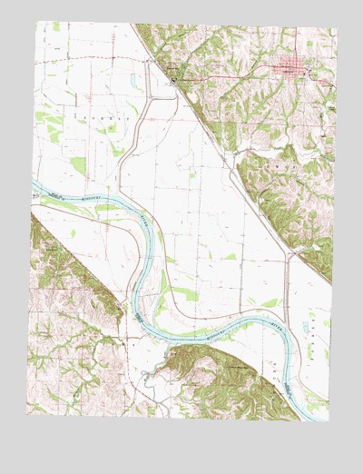
Oregon, MO USGS Topographic Map
Click on map above to begin viewing in our Map Viewer.

This topographic map contains these locations and features:
Feature Name Type Latitude Longitude GNIS ID View Map
Bluff City School (historical)SchoolN39.9533°W95.1647°734317View Map
Chambers School (historical)SchoolN39.9169°W95.1636°734319View Map
City of Forest CityCivilN39.9829°W95.1883°2394788View Map
City of OregonCivilN39.9861°W95.1433°2396076View Map
CurzonPopulated PlaceN39.9394°W95.1530°734318View Map
Davis BranchStreamN39.9542°W95.1678°716703View Map
Fitzmaurice Lake (historical)LakeN39.9947°W95.2244°734315View Map
Forest CityPopulated PlaceN39.9825°W95.1919°718074View Map
Forest City Post OfficePost OfficeN39.9822°W95.1930°2782574View Map
Forest City Union CemeteryCemeteryN39.9872°W95.1764°718075View Map
Hickory CreekStreamN39.9615°W95.1326°719445View Map
Holt County Sheriff's OfficeBuildingN39.9862°W95.1436°2752478View Map
Howley BranchStreamN39.9450°W95.2147°719935View Map
Iowa PointPopulated PlaceN39.9283°W95.2386°472808View Map
Iowa Point CemeteryCemeteryN39.9157°W95.2277°472809View Map
Lookout MountainSummitN39.8917°W95.1678°472811View Map
Martin CemeteryCemeteryN39.9001°W95.2441°472810View Map
Martin School (historical)SchoolN39.8994°W95.2461°482907View Map
Mill CreekStreamN39.9031°W95.1428°722338View Map
Mill CreekStreamN39.9453°W95.2461°472795View Map
Mission CreekStreamN39.9017°W95.2008°472814View Map
OregonPopulated PlaceN39.9869°W95.1450°730171View Map
Oregon Police DepartmentBuildingN39.9864°W95.1431°2752145View Map
Oregon Post OfficePost OfficeN39.9867°W95.1415°2782593View Map
Rock CreekStreamN39.9744°W95.1291°725447View Map
Schaefer School (historical)SchoolN39.9408°W95.2091°734316View Map
Schlotz BranchStreamN39.9394°W95.1558°726104View Map
South Holt Elementary SchoolSchoolN39.9853°W95.1384°2545404View Map
South Holt High SchoolSchoolN39.9847°W95.1384°2545433View Map
Southern Fire Protection DistrictBuildingN39.9880°W95.1445°2620837View Map
Township of ForestCivilN39.9861°W95.2227°766765View Map
Township of LewisCivilN39.9783°W95.1442°766767View Map
Welty ParkParkN39.9850°W95.1369°728508View Map
Willow Spring School (historical)SchoolN39.8886°W95.2094°482919View Map
Wolf RiverStreamN39.8986°W95.1916°472812View Map

Note: Coordinates in the location and feature list above are referenced to NAD83 datum.


Copyright (C) 2008-2024 Ryan Niemi / Sunset Dynamics ... All Rights Reserved