TopoQuest Logo
Do you find TopoQuest useful?
Help keep TopoQuest running and adding new maps/features by donating!
Bitcoin:  19c7KJd3qBynnjoSw5npx9KScwjBe4ifkT
Litecoin:  LXs6TkuXGGXo1vDsWCkWVdjQX94eUKd6ui
Home View Maps Find Maps Find Places Resources & Links


New Point, Missouri Topographic Map

USGS Map Title: New Point, MO
USGS Map MRC: 40095A1
DRG (GeoTIFF) Download: o40095a1.tif


Neighboring USGS Topographic Map Quads:


  Mound City, MO  
40095B2
 

  Maitland, MO  
40095B1
 

  Bolckow NW, MO  
40094B8
 

  Kimsey Creek, MO  
40095A2
 

  New Point, MO  
40095A1
 

  Fillmore, MO  
40094A8
 

  Oregon, MO  
39095H2
 

  Forbes, MO  
39095H1
 

  Amazonia, MO  
39094H8


Map MRC Location:

N41°
W96°
N41°
W95°
H8 H7 H6 H5 H4 H3 H2 H1
G8 G7 G6 G5 G4 G3 G2 G1
F8 F7 F6 F5 F4 F3 F2 F1
E8 E7 E6 E5 E4 E3 E2 E1
D8 D7 D6 D5 D4 D3 D2 D1
C8 C7 C6 C5 C4 C3 C2 C1
B8 B7 B6 B5 B4 B3 B2 B1
A8 A7 A6 A5 A4 A3 A2 A1
N40°
W96°
N40°
W95°

New Point, MO USGS 1:24K Topographic Map Preview:
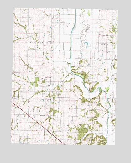
New Point, MO USGS Topographic Map
Click on map above to begin viewing in our Map Viewer.

This topographic map contains these locations and features:
Feature Name Type Latitude Longitude GNIS ID View Map
Arapahoe CreekStreamN40.0472°W95.0116°713364View Map
Cain Farm LakeReservoirN40.0425°W95.1011°761918View Map
Cain Farm Lake DamDamN40.0433°W95.1003°761917View Map
Carroll BranchStreamN40.0097°W95.0108°715432View Map
Christian CampLocaleN40.0256°W95.0794°743364View Map
Cowan CemeteryCemeteryN40.0594°W95.0877°743361View Map
Eureka SchoolSchoolN40.0733°W95.0314°717660View Map
Fairview CemeteryCemeteryN40.0944°W95.0783°743360View Map
Glen Meyer DamDamN40.0383°W95.0753°760917View Map
Glen Meyer LakeReservoirN40.0385°W95.0745°760918View Map
Hickory CreekStreamN40.0742°W95.0554°719448View Map
Hog CreekStreamN40.1192°W95.0516°719677View Map
Lone CornerPopulated PlaceN40.1155°W95.0025°737862View Map
Lone Corner SchoolSchoolN40.1158°W95.0025°721440View Map
Long Center School (historical)SchoolN40.1161°W95.0022°747053View Map
Marion School (historical)SchoolN40.0333°W95.0422°721870View Map
McGuire CemeteryCemeteryN40.0430°W95.0427°743362View Map
New PointPopulated PlaceN40.0547°W95.0791°740008View Map
New Point Census Designated PlaceCensusN40.0467°W95.0767°2587096View Map
Nichols CreekStreamN40.0642°W95.0569°723359View Map
Nichols GrovePopulated PlaceN40.0194°W95.0850°739624View Map
Nichols Grove CemeteryCemeteryN40.0261°W95.0841°743365View Map
Nichols Grove ChurchChurchN40.0258°W95.0841°723360View Map
Nodaway CemeteryCemeteryN40.0261°W95.0500°743363View Map
Nodaway River DitchCanalN40.1014°W95.0561°723396View Map
Owl CreekStreamN40.0817°W95.0014°723927View Map
Pedlar CreekStreamN40.0619°W95.0069°724177View Map
Richville School (historical)SchoolN40.0003°W95.0478°725281View Map
Township of HickoryCivilN40.0859°W95.1019°766766View Map
Township of NodawayCivilN40.0048°W95.0557°766771View Map
Triumph School (historical)SchoolN40.1125°W95.0800°727799View Map

Note: Coordinates in the location and feature list above are referenced to NAD83 datum.


Copyright (C) 2008-2025 Ryan Niemi / Sunset Dynamics ... All Rights Reserved