TopoQuest Logo
Do you find TopoQuest useful?
Help keep TopoQuest running and adding new maps/features by donating!
Bitcoin:  19c7KJd3qBynnjoSw5npx9KScwjBe4ifkT
Litecoin:  LXs6TkuXGGXo1vDsWCkWVdjQX94eUKd6ui
Home View Maps Find Maps Find Places Resources & Links


Oriskany, Virginia Topographic Map

USGS Map Title: Oriskany, VA
USGS Map MRC: 37079E8
DRG (GeoTIFF) Download: o37079e8.tif


Neighboring USGS Topographic Map Quads:


  Jordan Mines, VA  
37080F1
 

  Strom, VA  
37079F8
 

  Eagle Rock, VA  
37079F7
 

  New Castle, VA  
37080E1
 

  Oriskany, VA  
37079E8
 

  Salisbury, VA  
37079E7
 

  Catawba, VA  
37080D1
 

  Daleville, VA  
37079D8
 

  Villamont, VA  
37079D7


Map MRC Location:

N38°
W80°
N38°
W79°
H8 H7 H6 H5 H4 H3 H2 H1
G8 G7 G6 G5 G4 G3 G2 G1
F8 F7 F6 F5 F4 F3 F2 F1
E8 E7 E6 E5 E4 E3 E2 E1
D8 D7 D6 D5 D4 D3 D2 D1
C8 C7 C6 C5 C4 C3 C2 C1
B8 B7 B6 B5 B4 B3 B2 B1
A8 A7 A6 A5 A4 A3 A2 A1
N37°
W80°
N37°
W79°

Oriskany, VA USGS 1:24K Topographic Map Preview:
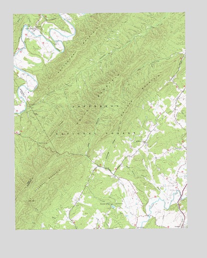
Oriskany, VA USGS Topographic Map
Click on map above to begin viewing in our Map Viewer.

This topographic map contains these locations and features:
Feature Name Type Latitude Longitude GNIS ID View Map
Anderson CemeteryCemeteryN37.6115°W79.9803°1481313View Map
Borden CreekStreamN37.5196°W79.8850°1481936View Map
Botetourt County JailBuildingN37.5010°W79.8768°2767077View Map
Botetourt County Sheriff's OfficeBuildingN37.5011°W79.8773°2767029View Map
Caldwell MountainSummitN37.5271°W79.9781°1482219View Map
Camp MontgomeryLocaleN37.5146°W79.9278°1482267View Map
Cedar RidgeRidgeN37.5671°W79.8867°1482411View Map
Craig Creek CampgroundLocaleN37.6132°W79.9606°1488794View Map
Crawford CemeteryCemeteryN37.5896°W79.9928°1482814View Map
Crooked RunStreamN37.5062°W79.9175°1482848View Map
Dry Run School (historical)SchoolN37.5285°W79.8834°1674400View Map
Fincastle Presbyterian CemeteryCemeteryN37.5003°W79.8752°2766683View Map
FlatwoodsPopulated PlaceN37.5451°W79.8795°1496897View Map
Flatwoods School (historical)SchoolN37.5454°W79.8792°1674399View Map
Green SpurRidgeN37.5599°W79.9223°1496929View Map
Howell MillsPopulated PlaceN37.5010°W79.9114°1496949View Map
Kelly HollowValleyN37.5427°W79.9480°1484539View Map
King Memorial ChurchChurchN37.6160°W79.9853°1484606View Map
Lees GapGapN37.5165°W79.9912°1484760View Map
Little Patterson CreekStreamN37.5701°W79.9906°1484952View Map
McKalester CemeteryCemeteryN37.6215°W79.9598°1485307View Map
Mount Pleasant ChurchChurchN37.5507°W79.9064°1485631View Map
Mud LickStreamN37.5690°W79.9917°1485719View Map
New Hope School (historical)SchoolN37.5574°W79.8984°1674401View Map
North Fork Catawba CreekStreamN37.5040°W79.9062°1485889View Map
North Fork ChurchChurchN37.5304°W79.9270°1485890View Map
North Fork School (historical)SchoolN37.5299°W79.9256°1674402View Map
OriskanyPopulated PlaceN37.6165°W79.9837°1497066View Map
Oriskany Post OfficePost OfficeN37.6168°W79.9848°2766264View Map
Patterson MountainSummitN37.6224°W79.9273°1486087View Map
Peck CemeteryCemeteryN37.5221°W79.8839°1486117View Map
Poorhouse HollowValleyN37.5359°W79.9357°1486347View Map
Price MountainSummitN37.5651°W79.9481°1486430View Map
Schoolhouse BranchStreamN37.6243°W79.9659°1486961View Map
Sugartree HollowValleyN37.6008°W79.8758°1487708View Map
Sukey Johnson BranchStreamN37.5254°W79.8989°1487709View Map
Sulphur RidgeRidgeN37.5587°W79.9689°1487713View Map
Sulphur SpringSpringN37.5504°W79.9826°1487715View Map
Switzer MountainSummitN37.5685°W79.9178°1497176View Map
Town BranchStreamN37.5162°W79.8787°1487966View Map
Tucker CemeteryCemeteryN37.6073°W79.9698°1488002View Map
Wilson BranchStreamN37.6176°W79.9895°1488408View Map
Woodville SpringSpringN37.5148°W79.9315°1488484View Map

Note: Coordinates in the location and feature list above are referenced to NAD83 datum.


Copyright (C) 2008-2024 Ryan Niemi / Sunset Dynamics ... All Rights Reserved