TopoQuest Logo
Do you find TopoQuest useful?
Help keep TopoQuest running and adding new maps/features by donating!
Bitcoin:  19c7KJd3qBynnjoSw5npx9KScwjBe4ifkT
Litecoin:  LXs6TkuXGGXo1vDsWCkWVdjQX94eUKd6ui
Home View Maps Find Maps Find Places Resources & Links


Eagle Rock, Virginia Topographic Map

USGS Map Title: Eagle Rock, VA
USGS Map MRC: 37079F7
DRG (GeoTIFF) Download: o37079f7.tif


Neighboring USGS Topographic Map Quads:


  Covington, VA  
37079G8
 

  Clifton Forge, VA  
37079G7
 

  Longdale Furnace, VA  
37079G6
 

  Strom, VA  
37079F8
 

  Eagle Rock, VA  
37079F7
 

  Sugarloaf Mountain, VA  
37079F6
 

  Oriskany, VA  
37079E8
 

  Salisbury, VA  
37079E7
 

  Buchanan, VA  
37079E6


Map MRC Location:

N38°
W80°
N38°
W79°
H8 H7 H6 H5 H4 H3 H2 H1
G8 G7 G6 G5 G4 G3 G2 G1
F8 F7 F6 F5 F4 F3 F2 F1
E8 E7 E6 E5 E4 E3 E2 E1
D8 D7 D6 D5 D4 D3 D2 D1
C8 C7 C6 C5 C4 C3 C2 C1
B8 B7 B6 B5 B4 B3 B2 B1
A8 A7 A6 A5 A4 A3 A2 A1
N37°
W80°
N37°
W79°

Eagle Rock, VA USGS 1:24K Topographic Map Preview:
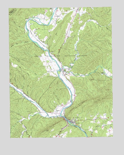
Eagle Rock, VA USGS Topographic Map
Click on map above to begin viewing in our Map Viewer.

This topographic map contains these locations and features:
Feature Name Type Latitude Longitude GNIS ID View Map
BaldwinPopulated PlaceN37.7399°W79.8506°1481433View Map
BessemerPopulated PlaceN37.6501°W79.8184°1494181View Map
Bethel ChurchChurchN37.7490°W79.7967°1481665View Map
Big BranchStreamN37.6846°W79.8398°1481710View Map
Big CreekStreamN37.7401°W79.8223°1481719View Map
Big HillSummitN37.7235°W79.8175°1481730View Map
Big Hill AirportAirportN37.7312°W79.8112°1498657View Map
Black LickStreamN37.6887°W79.8170°1481825View Map
Boggs HollowValleyN37.7312°W79.7555°1481906View Map
Craig CreekStreamN37.6454°W79.8134°1482803View Map
Crawford MountainSummitN37.6299°W79.8348°1482821View Map
Daggers SpringsPopulated PlaceN37.6857°W79.7617°1482893View Map
Dutchman BranchStreamN37.6621°W79.8528°1483185View Map
Eagle Mountain LookoutTowerN37.6340°W79.8295°1488796View Map
Eagle Mountain Station (historical)LocaleN37.6371°W79.7956°1674408View Map
Eagle RockPopulated PlaceN37.6407°W79.8012°1494212View Map
Eagle Rock Elementary SchoolSchoolN37.6564°W79.8113°1674407View Map
Eagle Rock Post OfficePost OfficeN37.6396°W79.7992°2766195View Map
Eagle Rock Volunteer Fire and Rescue Company 5BuildingN37.6407°W79.8011°2075553View Map
Eagle Rock Volunteer Rescue Squad HeadquartersBuildingN37.6407°W79.8009°2721141View Map
Emmanuel ChurchChurchN37.6415°W79.8025°1483298View Map
Fincastle DistrictCivilN37.6334°W79.8606°1927318View Map
GalaPopulated PlaceN37.6887°W79.8092°1483571View Map
Galatia ChurchChurchN37.6857°W79.8070°1483572View Map
Grange School (historical)SchoolN37.7415°W79.7934°1674404View Map
HadenPopulated PlaceN37.7165°W79.8339°1494230View Map
Haden CemeteryCemeteryN37.7229°W79.8409°1483883View Map
Hombarck BranchStreamN37.6715°W79.8670°1484174View Map
Hook BranchStreamN37.6624°W79.8528°1484195View Map
Junction School (historical)SchoolN37.6493°W79.8387°1674410View Map
Little Patterson CreekStreamN37.6418°W79.8620°1484953View Map
Locust Bottom ChurchChurchN37.7418°W79.8150°1485013View Map
Mill CreekStreamN37.6890°W79.8137°1487060View Map
Mount Zion ChurchChurchN37.6899°W79.8025°1485665View Map
Mud RunStreamN37.6940°W79.8098°1485728View Map
Patterson CreekStreamN37.6457°W79.8137°1486085View Map
Perkey AirportAirportN37.6644°W79.8095°2675590View Map
Phoenix BridgeBridgeN37.6490°W79.8312°1674409View Map
Rathole MountainSummitN37.6546°W79.7917°1494259View Map
Saville BranchStreamN37.6765°W79.8742°1486950View Map
Sheets MountainSummitN37.6632°W79.7584°1487171View Map
Shiloh ChurchChurchN37.6343°W79.7534°1487196View Map
Shiloh School (historical)SchoolN37.6329°W79.7570°1674405View Map
Shirkey Mill BranchStreamN37.7174°W79.8462°1487206View Map
Sinking CreekStreamN37.6912°W79.8128°1487260View Map
Stull RunStreamN37.7310°W79.8542°1487673View Map
Turkeypen HollowValleyN37.6406°W79.7502°1674403View Map
Whitten Station (historical)LocaleN37.6485°W79.8212°1674406View Map
Woods IslandIslandN37.7382°W79.8400°1488480View Map

Note: Coordinates in the location and feature list above are referenced to NAD83 datum.


Copyright (C) 2008-2025 Ryan Niemi / Sunset Dynamics ... All Rights Reserved