TopoQuest Logo
Do you find TopoQuest useful?
Help keep TopoQuest running and adding new maps/features by donating!
Bitcoin:  19c7KJd3qBynnjoSw5npx9KScwjBe4ifkT
Litecoin:  LXs6TkuXGGXo1vDsWCkWVdjQX94eUKd6ui
Home View Maps Find Maps Find Places Resources & Links


Otisville, Michigan Topographic Map

USGS Map Title: Otisville, MI
USGS Map MRC: 43083B5
DRG (GeoTIFF) Download: o43083b5.tif


Neighboring USGS Topographic Map Quads:


  Frankenmuth, MI  
43083C6
 

  Vassar, MI  
43083C5
 

  Juniata, MI  
43083C4
 

  Clio, MI  
43083B6
 

  Otisville, MI  
43083B5
 

  Columbiaville, MI  
43083B4
 

  Flint North, MI  
43083A6
 

  Davison, MI  
43083A5
 

  Elba, MI  
43083A4


Map MRC Location:

N44°
W84°
N44°
W83°
H8 H7 H6 H5 H4 H3 H2 H1
G8 G7 G6 G5 G4 G3 G2 G1
F8 F7 F6 F5 F4 F3 F2 F1
E8 E7 E6 E5 E4 E3 E2 E1
D8 D7 D6 D5 D4 D3 D2 D1
C8 C7 C6 C5 C4 C3 C2 C1
B8 B7 B6 B5 B4 B3 B2 B1
A8 A7 A6 A5 A4 A3 A2 A1
N43°
W84°
N43°
W83°

Otisville, MI USGS 1:24K Topographic Map Preview:
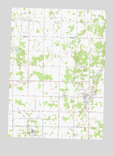
Otisville, MI USGS Topographic Map
Click on map above to begin viewing in our Map Viewer.

This topographic map contains these locations and features:
Feature Name Type Latitude Longitude GNIS ID View Map
Adams DrainCanalN43.2025°W83.6022°619817View Map
Arbela Township CemeteryCemeteryN43.2442°W83.5983°2554519View Map
Averill DrainCanalN43.1800°W83.5705°620378View Map
Barden BranchStreamN43.1603°W83.5666°620593View Map
Buell DrainCanalN43.1536°W83.5961°622204View Map
Buell LakeLakeN43.2090°W83.6164°622206View Map
Buell Lake County ParkParkN43.2056°W83.6167°2611469View Map
Burns DrainCanalN43.2420°W83.5588°622296View Map
Burroughs LakeLakeN43.1663°W83.5535°622322View Map
Camelot Villa Mobile Home CommunityPopulated PlaceN43.1306°W83.6125°2611394View Map
Clew Post Office (historical)Post OfficeN43.2163°W83.5703°2585860View Map
Coe DrainCanalN43.1706°W83.5375°623535View Map
Community Bible ChurchChurchN43.1694°W83.5597°2611242View Map
Covenant Hills CampgroundLocaleN43.1958°W83.5072°2611397View Map
Dock LakeLakeN43.1684°W83.5163°624727View Map
Drudge DrainCanalN43.1520°W83.6041°624889View Map
East Arbela ChurchChurchN43.2375°W83.6008°625110View Map
East Thetford Post Office (historical)Post OfficeN43.1792°W83.6028°2585855View Map
Emmanuel Baptist ChurchChurchN43.1728°W83.5242°2611245View Map
Forest Township Fire DepartmentBuildingN43.1718°W83.5182°2620065View Map
Frost DrainCanalN43.2272°W83.5413°626522View Map
Grass Roots AirportAirportN43.2402°W83.5209°1624047View Map
Hopkins CemeteryCemeteryN43.2231°W83.5655°628574View Map
Jackson BranchStreamN43.1692°W83.5663°629166View Map
McCormick LakeLakeN43.1650°W83.5213°631845View Map
Methodist United ChurchChurchN43.1728°W83.5253°2611244View Map
Misner DrainCanalN43.1909°W83.5230°632495View Map
Mount Nebo ChurchChurchN43.1278°W83.5783°2611694View Map
Mud LakeLakeN43.2260°W83.6247°633070View Map
Nunn DrainCanalN43.2486°W83.5633°633787View Map
Orchard Cove Manufactured Home CommunityPopulated PlaceN43.1631°W83.5289°2611399View Map
OtisvillePopulated PlaceN43.1661°W83.5244°634154View Map
Otisville Assembly of God ChurchChurchN43.1519°W83.5208°2611412View Map
Otisville Church of ChristChurchN43.2081°W83.5206°2611411View Map
Otisville Elementary SchoolSchoolN43.1675°W83.5278°2611398View Map
Otisville Police DepartmentBuildingN43.1694°W83.5184°2611400View Map
Otisville Post OfficePost OfficeN43.1742°W83.5206°2611414View Map
Otisville Station (historical)LocaleN43.1683°W83.5258°2611416View Map
Otisville United Methodist ChurchChurchN43.1667°W83.5264°2611243View Map
Parker Scothan DrainCanalN43.1261°W83.5430°634394View Map
Pettit ParkParkN43.1697°W83.5283°2611418View Map
Picnic LakeLakeN43.1614°W83.5205°634817View Map
Rogersville Station (historical)LocaleN43.1292°W83.5792°2585838View Map
Saint Francis Xavier ChurchChurchN43.1694°W83.5189°2611262View Map
Saint Timothy Lutheran ChurchChurchN43.1658°W83.5164°2611261View Map
Sand LakeLakeN43.1714°W83.5147°637183View Map
Smith Hill CemeteryCemeteryN43.1547°W83.5219°638153View Map
Smith Hill Cemetery Historical MarkerParkN43.1533°W83.5222°2582600View Map
Southwest SchoolSchoolN43.1284°W83.5380°638455View Map
Thetford and Arbela DrainCanalN43.2186°W83.6016°1614726View Map
Torrey DrainCanalN43.2234°W83.5772°1614976View Map
Township of ForestCivilN43.1799°W83.5202°1626294View Map
Village of OtisvilleCivilN43.1661°W83.5247°2399594View Map
West Forest ChurchChurchN43.1947°W83.5694°1616109View Map
Wilbur DrainCanalN43.1495°W83.6094°1616431View Map

Note: Coordinates in the location and feature list above are referenced to NAD83 datum.


Copyright (C) 2008-2024 Ryan Niemi / Sunset Dynamics ... All Rights Reserved