TopoQuest Logo
Do you find TopoQuest useful?
Help keep TopoQuest running and adding new maps/features by donating!
Bitcoin:  19c7KJd3qBynnjoSw5npx9KScwjBe4ifkT
Litecoin:  LXs6TkuXGGXo1vDsWCkWVdjQX94eUKd6ui
Home View Maps Find Maps Find Places Resources & Links


Columbiaville, Michigan Topographic Map

USGS Map Title: Columbiaville, MI
USGS Map MRC: 43083B4
DRG (GeoTIFF) Download: o43083b4.tif


Neighboring USGS Topographic Map Quads:


  Vassar, MI  
43083C5
 

  Juniata, MI  
43083C4
 

  Mayville, MI  
43083C3
 

  Otisville, MI  
43083B5
 

  Columbiaville, MI  
43083B4
 

  Barnes Lake, MI  
43083B3
 

  Davison, MI  
43083A5
 

  Elba, MI  
43083A4
 

  Lapeer, MI  
43083A3


Map MRC Location:

N44°
W84°
N44°
W83°
H8 H7 H6 H5 H4 H3 H2 H1
G8 G7 G6 G5 G4 G3 G2 G1
F8 F7 F6 F5 F4 F3 F2 F1
E8 E7 E6 E5 E4 E3 E2 E1
D8 D7 D6 D5 D4 D3 D2 D1
C8 C7 C6 C5 C4 C3 C2 C1
B8 B7 B6 B5 B4 B3 B2 B1
A8 A7 A6 A5 A4 A3 A2 A1
N43°
W84°
N43°
W83°

Columbiaville, MI USGS 1:24K Topographic Map Preview:
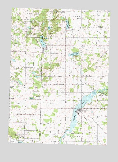
Columbiaville, MI USGS Topographic Map
Click on map above to begin viewing in our Map Viewer.

This topographic map contains these locations and features:
Feature Name Type Latitude Longitude GNIS ID View Map
Bethel ChurchChurchN43.1517°W83.4600°621216View Map
Church of Jesus ChristChurchN43.2172°W83.4091°623295View Map
Clute DrainStreamN43.1828°W83.4077°623505View Map
ColumbiavillePopulated PlaceN43.1567°W83.4105°623646View Map
Columbiaville Assembly of God ChurchChurchN43.1556°W83.4042°2575747View Map
Columbiaville Baptist ChurchChurchN43.1594°W83.3883°2575746View Map
Columbiaville Branch LibraryBuildingN43.1569°W83.4108°2575748View Map
Columbiaville Depot Historical MarkerParkN43.1561°W83.4087°2571254View Map
Columbiaville Elementary SchoolSchoolN43.1625°W83.4039°2575754View Map
Columbiaville Fire DepartmentBuildingN43.1565°W83.4077°2575749View Map
Columbiaville Post OfficePost OfficeN43.1614°W83.4042°2575752View Map
Columbiaville Station (historical)LocaleN43.1578°W83.4106°2575745View Map
Columbiaville United Methodist ChurchChurchN43.1619°W83.4039°2575753View Map
Crawford Lake DrainCanalN43.1611°W83.4850°624038View Map
Davison Hills Mobile Home ParkPopulated PlaceN43.1264°W83.4972°2611352View Map
Gawdy LakeLakeN43.1666°W83.4722°626691View Map
Genesee-Otter Lake CampgroundLocaleN43.1944°W83.4700°2572309View Map
Hart LakeLakeN43.2323°W83.4520°627875View Map
Harvey LakeLakeN43.2321°W83.4779°627904View Map
Hemmingway and Whipple DrainStreamN43.1753°W83.3927°628095View Map
Hemmingway LakeLakeN43.2085°W83.4196°628096View Map
Henry DrainStreamN43.1350°W83.4272°628114View Map
Hollenbeck CemeteryCemeteryN43.1806°W83.4299°628432View Map
Johnson DrainCanalN43.1759°W83.4947°629331View Map
Joslyn DrainStreamN43.2153°W83.3808°629403View Map
Lake HensonReservoirN43.2064°W83.4447°1953379View Map
Lakeville Community Free Methodist ChurchChurchN43.1661°W83.4603°2611693View Map
Lakeville High SchoolSchoolN43.1689°W83.4619°630069View Map
Marathon Medical ClinicHospitalN43.1603°W83.4050°2575751View Map
Marathon Post Office (historical)Post OfficeN43.1769°W83.3908°2575328View Map
Mud LakeLakeN43.2226°W83.4556°632959View Map
North Branch Flint RiverStreamN43.1764°W83.3780°633509View Map
North LakeLakeN43.2362°W83.4293°633593View Map
Otter LakeLakeN43.2181°W83.4597°634189View Map
Otter LakePopulated PlaceN43.2134°W83.4544°634196View Map
Otter Lake Branch LibraryBuildingN43.2122°W83.4583°2575617View Map
Otter Lake CemeteryCemeteryN43.2167°W83.4506°2575795View Map
Otter Lake Church of the NazareneChurchN43.2092°W83.4681°2575608View Map
Otter Lake Elementary SchoolSchoolN43.2103°W83.4519°2575616View Map
Otter Lake Fire and RescueBuildingN43.2119°W83.4585°2575618View Map
Otter Lake ParkParkN43.2142°W83.4586°2575677View Map
Otter Lake Post OfficePost OfficeN43.2128°W83.4583°2575619View Map
Otter Lake Seventh Day ChurchChurchN43.2161°W83.4544°2575610View Map
Otter Lake Station (historical)LocaleN43.2100°W83.4586°2575613View Map
Otter Lake United Methodist ChurchChurchN43.2139°W83.4542°2575609View Map
Otter Lake Village CampgroundLocaleN43.2142°W83.4586°2575615View Map
Powder Horn LakeLakeN43.2241°W83.4610°635369View Map
Saint John's Episcopal ChurchChurchN43.2139°W83.4581°2575611View Map
Sister LakesLakeN43.1904°W83.4695°638014View Map
South Branch Flint RiverStreamN43.1764°W83.3780°638282View Map
Springhill SchoolSchoolN43.2486°W83.4305°638628View Map
Tau Beta CampLocaleN43.1806°W83.3936°1614603View Map
Township of MarathonCivilN43.1890°W83.4051°1626682View Map
United Methodist Church Historical MarkerParkN43.1558°W83.4100°2571255View Map
Van Natter LakeLakeN43.1810°W83.4868°1615481View Map
Village of ColumbiavilleCivilN43.1572°W83.4072°2398604View Map
Village of Otter LakeCivilN43.2138°W83.4597°2399597View Map
Village of Otter Lake MuseumBuildingN43.2136°W83.4586°2575614View Map
Walker DrainCanalN43.1664°W83.4827°1615693View Map
William Peter Mansion Historical MarkerParkN43.1561°W83.4113°2571256View Map
Wolverine CampgroundLocaleN43.1611°W83.3839°2575750View Map
Woodlawn CemeteryCemeteryN43.1639°W83.4011°1616770View Map

Note: Coordinates in the location and feature list above are referenced to NAD83 datum.


Copyright (C) 2008-2024 Ryan Niemi / Sunset Dynamics ... All Rights Reserved