TopoQuest Logo
Do you find TopoQuest useful?
Help keep TopoQuest running and adding new maps/features by donating!
Bitcoin:  19c7KJd3qBynnjoSw5npx9KScwjBe4ifkT
Litecoin:  LXs6TkuXGGXo1vDsWCkWVdjQX94eUKd6ui
Home View Maps Find Maps Find Places Resources & Links


Frankenmuth, Michigan Topographic Map

USGS Map Title: Frankenmuth, MI
USGS Map MRC: 43083C6
DRG (GeoTIFF) Download: o43083c6.tif


Neighboring USGS Topographic Map Quads:


  Saginaw NE, MI  
43083D7
 

  Reese, MI  
43083D6
 

  Gilford, MI  
43083D5
 

  Birch Run North, MI  
43083C7
 

  Frankenmuth, MI  
43083C6
 

  Vassar, MI  
43083C5
 

  Birch Run South, MI  
43083B7
 

  Clio, MI  
43083B6
 

  Otisville, MI  
43083B5


Map MRC Location:

N44°
W84°
N44°
W83°
H8 H7 H6 H5 H4 H3 H2 H1
G8 G7 G6 G5 G4 G3 G2 G1
F8 F7 F6 F5 F4 F3 F2 F1
E8 E7 E6 E5 E4 E3 E2 E1
D8 D7 D6 D5 D4 D3 D2 D1
C8 C7 C6 C5 C4 C3 C2 C1
B8 B7 B6 B5 B4 B3 B2 B1
A8 A7 A6 A5 A4 A3 A2 A1
N43°
W84°
N43°
W83°

Frankenmuth, MI USGS 1:24K Topographic Map Preview:
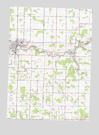
Frankenmuth, MI USGS Topographic Map
Click on map above to begin viewing in our Map Viewer.

This topographic map contains these locations and features:
Feature Name Type Latitude Longitude GNIS ID View Map
Arabela United Methodist ChurchChurchN43.2667°W83.6417°2554330View Map
Arbela CemeteryCemeteryN43.2800°W83.6666°620189View Map
Baker McPherson DrainCanalN43.2945°W83.6336°619741View Map
Barrett DrainCanalN43.2770°W83.7408°620640View Map
Blessed Trinity Catholic ChurchChurchN43.3300°W83.7278°2558838View Map
Block DrainCanalN43.3045°W83.7036°621597View Map
Boots DrainCanalN43.2539°W83.7136°621740View Map
Brand DrainCanalN43.2634°W83.6791°621884View Map
Brenner DrainCanalN43.2789°W83.6994°621922View Map
Calkins DrainCanalN43.2739°W83.6527°622461View Map
City of FrankenmuthCivilN43.3321°W83.7396°1626303View Map
Cole CreekStreamN43.3222°W83.6733°623582View Map
Covenant Health CareHospitalN43.3467°W83.7389°2558851View Map
Cross ParkParkN43.3103°W83.7367°2558854View Map
EF Rittmueller Middle SchoolSchoolN43.3350°W83.7253°2558848View Map
Elliot BranchStreamN43.2970°W83.6950°625476View Map
Ellis DrainCanalN43.3292°W83.6350°625487View Map
Elva Post Office (historical)Post OfficeN43.2808°W83.6619°2553986View Map
Fortress Golf CourseLocaleN43.3250°W83.7483°2558846View Map
FrankenmuthPopulated PlaceN43.3317°W83.7380°626405View Map
Frankenmuth Bavarian Inn Historical MarkerParkN43.3264°W83.7403°2559027View Map
Frankenmuth Bible ChurchChurchN43.3442°W83.7481°2558837View Map
Frankenmuth City HallBuildingN43.3361°W83.7403°2558845View Map
Frankenmuth Fire DepartmentBuildingN43.3361°W83.7403°2636172View Map
Frankenmuth High SchoolSchoolN43.3356°W83.7319°2558849View Map
Frankenmuth Historical MuseumBuildingN43.3281°W83.7394°2558841View Map
Frankenmuth Jellystone ParkLocaleN43.3181°W83.7342°2558835View Map
Frankenmuth Police DeptBuildingN43.3362°W83.7409°2558840View Map
Frankenmuth Post OfficePost OfficeN43.3364°W83.7375°2558844View Map
Frankenmuth River PlaceLocaleN43.3236°W83.7394°2558894View Map
Frankenmuth Township CemeteryCemeteryN43.3280°W83.7486°2559004View Map
Frankenmuth United Methodist ChurchChurchN43.3383°W83.7339°2558836View Map
Galsterer DrainCanalN43.3317°W83.7064°626618View Map
Hadstadt DrainCanalN43.2692°W83.7427°627588View Map
Hammond CemeteryCemeteryN43.2933°W83.7238°627699View Map
Hammond DrainCanalN43.2997°W83.7180°627700View Map
Heritage ParkParkN43.3306°W83.7353°2558842View Map
Hubenstricker DrainCanalN43.2875°W83.7052°628751View Map
James E Wickson Memorial LibraryBuildingN43.3314°W83.7397°2558843View Map
Kemp DrainCanalN43.2792°W83.7466°629566View Map
List DrainCanalN43.3028°W83.7272°630538View Map
List Elementary SchoolSchoolN43.3350°W83.7289°2558847View Map
McKenzie DrainCanalN43.3525°W83.6333°631944View Map
Memorial ParkParkN43.3325°W83.7289°2558853View Map
Michigan Military and Space MusuemBuildingN43.3197°W83.7353°2558852View Map
Michigan's German Settlers Historical MarkerParkN43.3258°W83.7408°2559026View Map
Millington CreekStreamN43.3342°W83.6436°632414View Map
Ortner DrainCanalN43.3714°W83.7286°634115View Map
Perry CreekStreamN43.3250°W83.6527°634669View Map
Pickett DrainCanalN43.2536°W83.6461°634808View Map
Pine Ridge RV CampgroundLocaleN43.2550°W83.7361°2558975View Map
Pleasant Ridge ChurchChurchN43.2520°W83.7361°635118View Map
Saint John's Evangelical Lutheran CemeteryCemeteryN43.3292°W83.7453°2559003View Map
Saint John's Lutheran ChurchChurchN43.3361°W83.7231°2558839View Map
Saint Lorenz SchoolSchoolN43.3370°W83.7491°636830View Map
Saint Martin Lutheran ChurchChurchN43.2644°W83.7369°2558977View Map
Schluckbier DrainCanalN43.3142°W83.7172°637343View Map
Smith DrainCanalN43.2742°W83.6708°638150View Map
Sprague DrainCanalN43.3145°W83.6377°638526View Map
Timbers Golf CourseLocaleN43.3122°W83.6594°2553950View Map
Township of ArbelaCivilN43.2644°W83.6391°1625842View Map
Township of TuscolaCivilN43.3492°W83.6423°1627180View Map
TuscolaPopulated PlaceN43.3264°W83.6572°1615209View Map
Tuscola Assembly of God ChurchChurchN43.3264°W83.6597°2554355View Map
Tuscola CemeteryCemeteryN43.3261°W83.6491°1615210View Map
Tuscola Community ChurchChurchN43.3283°W83.6583°2554356View Map
Tuscola Post Office (historical)Post OfficeN43.3267°W83.6589°2554357View Map
Tuscola Township HallBuildingN43.3281°W83.6522°2553933View Map
Whitney SchoolSchoolN43.2878°W83.6619°1616396View Map
Wilderness Trails Animal ParkLocaleN43.2550°W83.7347°2558976View Map
Wm 'Tiny' Zehnder FieldAirportN43.3140°W83.7116°1623903View Map
Zehnders Restaurant Historical MarkerParkN43.3267°W83.7408°2559037View Map

Note: Coordinates in the location and feature list above are referenced to NAD83 datum.


Copyright (C) 2008-2025 Ryan Niemi / Sunset Dynamics ... All Rights Reserved