TopoQuest Logo
Do you find TopoQuest useful?
Help keep TopoQuest running and adding new maps/features by donating!
Bitcoin:  19c7KJd3qBynnjoSw5npx9KScwjBe4ifkT
Litecoin:  LXs6TkuXGGXo1vDsWCkWVdjQX94eUKd6ui
Home View Maps Find Maps Find Places Resources & Links


Ovando, Montana Topographic Map

USGS Map Title: Ovando, MT
USGS Map MRC: 47113A2
DRG (GeoTIFF) Download: o47113a2.tif


Neighboring USGS Topographic Map Quads:


  Morrell Mountain, MT  
47113B3
 

  Dunham Point, MT  
47113B2
 

  Spread Mountain, MT  
47113B1
 

  Woodworth, MT  
47113A3
 

  Ovando, MT  
47113A2
 

  Ovando Mountain, MT  
47113A1
 

  Bata Mountain, MT  
46113H3
 

  Chamberlain Mountain, MT  
46113H2
 

  Browns Lake, MT  
46113H1


Map MRC Location:

N48°
W114°
N48°
W113°
H8 H7 H6 H5 H4 H3 H2 H1
G8 G7 G6 G5 G4 G3 G2 G1
F8 F7 F6 F5 F4 F3 F2 F1
E8 E7 E6 E5 E4 E3 E2 E1
D8 D7 D6 D5 D4 D3 D2 D1
C8 C7 C6 C5 C4 C3 C2 C1
B8 B7 B6 B5 B4 B3 B2 B1
A8 A7 A6 A5 A4 A3 A2 A1
N47°
W114°
N47°
W113°

Ovando, MT USGS 1:24K Topographic Map Preview:
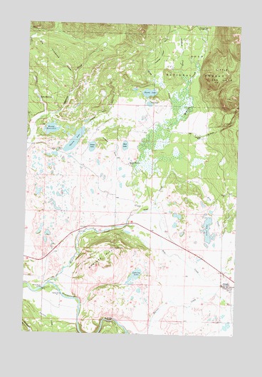
Ovando, MT USGS Topographic Map
Click on map above to begin viewing in our Map Viewer.

This topographic map contains these locations and features:
Feature Name Type Latitude Longitude GNIS ID View Map
15N12W05CDCA01 WellWellN47.0785°W113.1478°820606View Map
15N12W29BDBD01 WellWellN47.0294°W113.1478°820270View Map
15N12W32CABC01 WellWellN47.0113°W113.1487°820130View Map
15N12W33BBAA01 WellWellN47.0194°W113.1287°820191View Map
15N12W33BBBA01 WellWellN47.0194°W113.1320°820192View Map
15N12W33BBBA02 WellWellN47.0194°W113.1326°820193View Map
16N12W30AACC01 WellWellN47.1188°W113.1589°820861View Map
Bandy ReservoirReservoirN47.0823°W113.2367°779322View Map
Bandy Reservoir DamDamN47.0849°W113.2376°796517View Map
Barbour DitchCanalN47.0738°W113.2031°779348View Map
Blackfoot ChurchChurchN47.0202°W113.1331°1803297View Map
Dick CreekStreamN47.0477°W113.1887°782367View Map
Dry Cottonwood CreekStreamN47.0860°W113.2440°782553View Map
Dunham CreekStreamN47.1024°W113.1567°782698View Map
Dunham Creek DitchCanalN47.1086°W113.1798°782699View Map
Hoyt CreekStreamN47.0513°W113.1740°785124View Map
James LakeLakeN47.0753°W113.2123°785416View Map
Jones LakeLakeN47.0426°W113.1425°785562View Map
Lahrity LakeLakeN47.0242°W113.1842°785890View Map
Little Red HillsSummitN47.1022°W113.1403°786348View Map
Lobe CreekStreamN47.0052°W113.1978°786406View Map
Lost CreekStreamN47.1047°W113.2237°778817View Map
Lynn ReservoirReservoirN47.0945°W113.2442°786733View Map
McCabe CreekStreamN47.0719°W113.1512°786985View Map
Monture Creek CampgroundLocaleN47.1233°W113.1456°787586View Map
Monture Creek Fishing Access SiteLocaleN47.0372°W113.2234°1744369View Map
Monture Hereford RanchLocaleN47.0685°W113.1906°787590View Map
Monture HillSummitN47.0344°W113.1978°787591View Map
Mud LakeLakeN47.0759°W113.1928°787795View Map
OvandoPopulated PlaceN47.0202°W113.1331°788528View Map
Ovando CemeteryCemeteryN47.0177°W113.1253°1803339View Map
Ovando Census Designated PlaceCensusN47.0207°W113.1717°2409005View Map
Ovando Elementary SchoolSchoolN47.0197°W113.1284°1803315View Map
Ovando Post OfficePost OfficeN47.0196°W113.1316°1803379View Map
Ovando Volunteer Fire DepartmentBuildingN47.0203°W113.1328°2546686View Map
Pearson CreekStreamN47.0085°W113.2426°788733View Map
Rice LakeLakeN47.0928°W113.1790°789561View Map
Scotty Brown BridgeBridgeN47.0180°W113.2401°790161View Map
Shoup CreekStreamN47.0841°W113.1723°790458View Map
Shoup LakeLakeN47.0974°W113.1790°790459View Map
Shoup Lake DamDamN47.0983°W113.1792°796522View Map
Two Creek RanchLocaleN47.0802°W113.1478°792548View Map
Upsata LakeLakeN47.0776°W113.2228°788475View Map
Upsata Lake Fishing Access SiteLocaleN47.0733°W113.2312°1744360View Map
Warren CreekStreamN47.0013°W113.1884°792843View Map

Note: Coordinates in the location and feature list above are referenced to NAD83 datum.


Copyright (C) 2008-2024 Ryan Niemi / Sunset Dynamics ... All Rights Reserved