TopoQuest Logo
Do you find TopoQuest useful?
Help keep TopoQuest running and adding new maps/features by donating!
Bitcoin:  19c7KJd3qBynnjoSw5npx9KScwjBe4ifkT
Litecoin:  LXs6TkuXGGXo1vDsWCkWVdjQX94eUKd6ui
Home View Maps Find Maps Find Places Resources & Links


Overbrook, Kansas Topographic Map

USGS Map Title: Overbrook, KS
USGS Map MRC: 38095G5
DRG (GeoTIFF) Download: o38095g5.tif


Neighboring USGS Topographic Map Quads:


  Wakarusa, KS  
38095H6
 

  Richland, KS  
38095H5
 

  Clinton, KS  
38095H4
 

  Carbondale, KS  
38095G6
 

  Overbrook, KS  
38095G5
 

  Globe, KS  
38095G4
 

  Lyndon NW, KS  
38095F6
 

  Vassar, KS  
38095F5
 

  Ottawa NW, KS  
38095F4


Map MRC Location:

N39°
W96°
N39°
W95°
H8 H7 H6 H5 H4 H3 H2 H1
G8 G7 G6 G5 G4 G3 G2 G1
F8 F7 F6 F5 F4 F3 F2 F1
E8 E7 E6 E5 E4 E3 E2 E1
D8 D7 D6 D5 D4 D3 D2 D1
C8 C7 C6 C5 C4 C3 C2 C1
B8 B7 B6 B5 B4 B3 B2 B1
A8 A7 A6 A5 A4 A3 A2 A1
N38°
W96°
N38°
W95°

Overbrook, KS USGS 1:24K Topographic Map Preview:
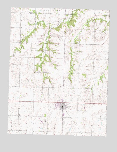
Overbrook, KS USGS Topographic Map
Click on map above to begin viewing in our Map Viewer.

This topographic map contains these locations and features:
Feature Name Type Latitude Longitude GNIS ID View Map
City of OverbrookCivilN38.7794°W95.5568°2396111View Map
Grace Community ChurchChurchN38.7827°W95.5529°2690529View Map
Hidden Springs Golf CourseLocaleN38.7639°W95.5772°2694570View Map
Kinney (historical)LocaleN38.8417°W95.6141°481920View Map
Lickskillet SchoolSchoolN38.8408°W95.5383°479472View Map
Osage County Fire District 4 OverbrookBuildingN38.7787°W95.5570°2111688View Map
OverbrookPopulated PlaceN38.7806°W95.5572°479465View Map
Overbrook Attendance CenterSchoolN38.7818°W95.5589°2506526View Map
Overbrook Bible ChurchChurchN38.7819°W95.5635°2690530View Map
Overbrook CemeteryCemeteryN38.7749°W95.5480°2673340View Map
Overbrook City HallBuildingN38.7787°W95.5570°2693070View Map
Overbrook FairgroundsLocaleN38.7811°W95.5532°2692800View Map
Overbrook Police DepartmentBuildingN38.7787°W95.5570°2503803View Map
Overbrook Post OfficePost OfficeN38.7783°W95.5564°2511077View Map
Overbrook Public LibraryBuildingN38.7782°W95.5571°2692629View Map
Overbrook Sewer Treatment PlantLocaleN38.7701°W95.5553°2691912View Map
Overbrook United Methodist ChurchChurchN38.7867°W95.5580°2689514View Map
Overbrook Water TowerTowerN38.7775°W95.5521°2509603View Map
Pleasant Valley SchoolSchoolN38.7686°W95.6116°479466View Map
Ridgeway CemeteryCemeteryN38.8411°W95.6066°479471View Map
Ridgeway SchoolSchoolN38.8353°W95.5978°479470View Map
Snoopys Airport (historical)AirportN38.8083°W95.5989°481323View Map
Strowbridge CreekStreamN38.8556°W95.5744°479450View Map
SwissvalePopulated PlaceN38.8336°W95.5803°484891View Map
Township of ElkCivilN38.8043°W95.5564°479469View Map

Note: Coordinates in the location and feature list above are referenced to NAD83 datum.


Copyright (C) 2008-2024 Ryan Niemi / Sunset Dynamics ... All Rights Reserved