TopoQuest Logo
Do you find TopoQuest useful?
Help keep TopoQuest running and adding new maps/features by donating!
Bitcoin:  19c7KJd3qBynnjoSw5npx9KScwjBe4ifkT
Litecoin:  LXs6TkuXGGXo1vDsWCkWVdjQX94eUKd6ui
Home View Maps Find Maps Find Places Resources & Links


Clinton, Kansas Topographic Map

USGS Map Title: Clinton, KS
USGS Map MRC: 38095H4
DRG (GeoTIFF) Download: o38095h4.tif


Neighboring USGS Topographic Map Quads:


  Grantville, KS  
39095A5
 

  Perry, KS  
39095A4
 

  Williamstown, KS  
39095A3
 

  Richland, KS  
38095H5
 

  Clinton, KS  
38095H4
 

  Lawrence West, KS  
38095H3
 

  Overbrook, KS  
38095G5
 

  Globe, KS  
38095G4
 

  Lone Star, KS  
38095G3


Map MRC Location:

N39°
W96°
N39°
W95°
H8 H7 H6 H5 H4 H3 H2 H1
G8 G7 G6 G5 G4 G3 G2 G1
F8 F7 F6 F5 F4 F3 F2 F1
E8 E7 E6 E5 E4 E3 E2 E1
D8 D7 D6 D5 D4 D3 D2 D1
C8 C7 C6 C5 C4 C3 C2 C1
B8 B7 B6 B5 B4 B3 B2 B1
A8 A7 A6 A5 A4 A3 A2 A1
N38°
W96°
N38°
W95°

Clinton, KS USGS 1:24K Topographic Map Preview:
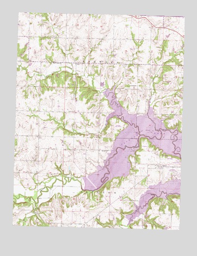
Clinton, KS USGS Topographic Map
Click on map above to begin viewing in our Map Viewer.

This topographic map contains these locations and features:
Feature Name Type Latitude Longitude GNIS ID View Map
Belvoir (historical)LocaleN38.9203°W95.4280°481830View Map
Belvoir School (historical)SchoolN38.9203°W95.4303°479109View Map
ClintonPopulated PlaceN38.9117°W95.3905°479107View Map
Clinton CemeteryCemeteryN38.9136°W95.4108°479108View Map
Clinton LakeReservoirN38.8976°W95.3883°479837View Map
Clinton Township Fire DepartmentBuildingN38.9103°W95.3909°2111204View Map
Coon CreekStreamN38.9333°W95.3925°479111View Map
Deer CreekStreamN38.9297°W95.4061°479110View Map
Deer Creek School (historical)SchoolN38.9711°W95.4733°479113View Map
Dry CreekStreamN38.9406°W95.4233°479105View Map
Elk CreekStreamN38.8881°W95.4836°479104View Map
Kanawaka Township Fire DepartmentBuildingN38.9863°W95.4009°2111470View Map
Mound View CemeteryCemeteryN38.9427°W95.4564°479106View Map
StullPopulated PlaceN38.9711°W95.4561°479114View Map
Stull CemeteryCemeteryN38.9716°W95.4539°2673257View Map
Township of ClintonCivilN38.8996°W95.4076°479495View Map
Township of KanwakaCivilN38.9654°W95.4171°479103View Map
Yarnold School (historical)SchoolN38.9589°W95.4097°479112View Map

Note: Coordinates in the location and feature list above are referenced to NAD83 datum.


Copyright (C) 2008-2024 Ryan Niemi / Sunset Dynamics ... All Rights Reserved