TopoQuest Logo
Do you find TopoQuest useful?
Help keep TopoQuest running and adding new maps/features by donating!
Bitcoin:  19c7KJd3qBynnjoSw5npx9KScwjBe4ifkT
Litecoin:  LXs6TkuXGGXo1vDsWCkWVdjQX94eUKd6ui
Home View Maps Find Maps Find Places Resources & Links


Ovett, Mississippi Topographic Map

USGS Map Title: Ovett, MS
USGS Map MRC: 31089D1
DRG (GeoTIFF) Download: o31089d1.tif


Neighboring USGS Topographic Map Quads:


  Ellisville, MS  
31089E2
 

  Lanham, MS  
31089E1
 

  Strengthford, MS  
31088E8
 

  Barrontown, MS  
31089D2
 

  Ovett, MS  
31089D1
 

  Rhodes, MS  
31088D8
 

  Carterville, MS  
31089C2
 

  Ovett SE, MS  
31089C1
 

  Richton, MS  
31088C8


Map MRC Location:

N32°
W90°
N32°
W89°
H8 H7 H6 H5 H4 H3 H2 H1
G8 G7 G6 G5 G4 G3 G2 G1
F8 F7 F6 F5 F4 F3 F2 F1
E8 E7 E6 E5 E4 E3 E2 E1
D8 D7 D6 D5 D4 D3 D2 D1
C8 C7 C6 C5 C4 C3 C2 C1
B8 B7 B6 B5 B4 B3 B2 B1
A8 A7 A6 A5 A4 A3 A2 A1
N31°
W90°
N31°
W89°

Ovett, MS USGS 1:24K Topographic Map Preview:
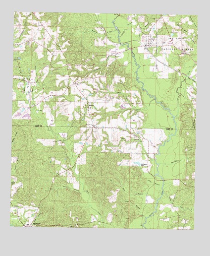
Ovett, MS USGS Topographic Map
Click on map above to begin viewing in our Map Viewer.

This topographic map contains these locations and features:
Feature Name Type Latitude Longitude GNIS ID View Map
Allan BranchStreamN31.3946°W89.0223°692386View Map
Baylss BranchStreamN31.4696°W89.0389°705112View Map
Beech CemeteryCemeteryN31.4829°W89.1162°692523View Map
Big Thick BranchStreamN31.3918°W89.0256°692612View Map
Bridge BranchStreamN31.4868°W89.0548°692703View Map
Carl Hollomans Pond DamDamN31.4068°W89.0384°695378View Map
County Line Baptist ChurchChurchN31.4350°W89.0705°692990View Map
County Line CemeteryCemeteryN31.4343°W89.0703°707339View Map
Driving BranchStreamN31.3968°W89.0751°693110View Map
Dry ProngStreamN31.4432°W89.1109°693128View Map
Faith Baptist ChurchChurchN31.4816°W89.0317°705115View Map
Fox (historical)LocaleN31.4899°W89.0634°705117View Map
Hall BranchStreamN31.4829°W89.0495°693399View Map
Hog BranchStreamN31.4643°W89.0073°693494View Map
Hollomans Mills (historical)LocaleN31.4510°W89.0295°705118View Map
Hollomans PondReservoirN31.4133°W89.0393°693504View Map
Hull Mill (historical)LocaleN31.4696°W89.0181°705119View Map
Jesus Name ChurchChurchN31.4777°W89.0073°693615View Map
Lancaster BranchStreamN31.4796°W89.0484°693683View Map
Lancaster CemeteryCemeteryN31.4757°W89.0601°693684View Map
Linda CreekStreamN31.3966°W89.0214°693726View Map
McInnis Mill (historical)LocaleN31.4549°W89.0587°705121View Map
Mike BranchStreamN31.3816°W89.0331°693963View Map
Mill CreekStreamN31.4155°W89.0273°693983View Map
OvettPopulated PlaceN31.4854°W89.0328°694284View Map
Ovett Baptist ChurchChurchN31.4843°W89.0317°705123View Map
Ovett CemeteryCemeteryN31.4846°W89.0248°694285View Map
Ovett Post OfficePost OfficeN31.4820°W89.0352°2768661View Map
Ovett SchoolSchoolN31.4846°W89.0298°707381View Map
Ovett Volunteer Fire DepartmentBuildingN31.4873°W89.0330°2668006View Map
Piney Grove ChurchChurchN31.4918°W89.0664°694400View Map
Redbank BranchStreamN31.4910°W89.0567°694535View Map
RunnelstownPopulated PlaceN31.3757°W89.1117°694631View Map
Runnelstown Elementary SchoolSchoolN31.3763°W89.1126°705951View Map
Runnelstown First Baptist ChurchChurchN31.3752°W89.1134°2596989View Map
Runnelstown Volunteer Fire Department Station 1 HeadquartersBuildingN31.3761°W89.1010°2667682View Map
Smith Mill CreekStreamN31.4507°W89.0289°694828View Map
Sweetwater CreekStreamN31.4130°W89.0251°694920View Map
TallahalaPopulated PlaceN31.3866°W89.1231°694931View Map
Tiger CreekStreamN31.4396°W89.0153°694979View Map
Vickers Lake DamDamN31.4318°W89.1201°695384View Map
Vickers Lake DamDamN31.4335°W89.1117°695386View Map
Vickers Lake DamDamN31.4352°W89.1201°695387View Map
Welcome Home Jesus Name ChurchChurchN31.4589°W89.0030°2597064View Map
WhitfieldPopulated PlaceN31.4452°W89.0745°692320View Map
Whitfield Baptist ChurchChurchN31.4479°W89.0731°705126View Map
Whitfield Line SchoolSchoolN31.4446°W89.0720°705127View Map
Woodard CemeteryCemeteryN31.4238°W89.0064°695214View Map

Note: Coordinates in the location and feature list above are referenced to NAD83 datum.


Copyright (C) 2008-2025 Ryan Niemi / Sunset Dynamics ... All Rights Reserved