TopoQuest Logo
Do you find TopoQuest useful?
Help keep TopoQuest running and adding new maps/features by donating!
Bitcoin:  19c7KJd3qBynnjoSw5npx9KScwjBe4ifkT
Litecoin:  LXs6TkuXGGXo1vDsWCkWVdjQX94eUKd6ui
Home View Maps Find Maps Find Places Resources & Links


Owdoms, South Carolina Topographic Map

USGS Map Title: Owdoms, SC
USGS Map MRC: 33081H8
DRG (GeoTIFF) Download: o33081h8.tif


Neighboring USGS Topographic Map Quads:


  Kirksey, SC  
34082A1
 

  Good Hope, SC  
34081A8
 

  Saluda North, SC  
34081A7
 

  Limestone, SC  
33082H1
 

  Owdoms, SC  
33081H8
 

  Saluda South, SC  
33081H7
 

  Red Hill, SC  
33082G1
 

  Edgefield, SC  
33081G8
 

  Johnston, SC  
33081G7


Map MRC Location:

N34°
W82°
N34°
W81°
H8 H7 H6 H5 H4 H3 H2 H1
G8 G7 G6 G5 G4 G3 G2 G1
F8 F7 F6 F5 F4 F3 F2 F1
E8 E7 E6 E5 E4 E3 E2 E1
D8 D7 D6 D5 D4 D3 D2 D1
C8 C7 C6 C5 C4 C3 C2 C1
B8 B7 B6 B5 B4 B3 B2 B1
A8 A7 A6 A5 A4 A3 A2 A1
N33°
W82°
N33°
W81°

Owdoms, SC USGS 1:24K Topographic Map Preview:
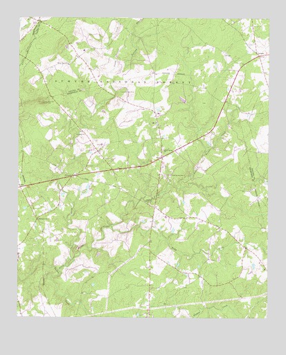
Owdoms, SC USGS Topographic Map
Click on map above to begin viewing in our Map Viewer.

This topographic map contains these locations and features:
Feature Name Type Latitude Longitude GNIS ID View Map
Dorn CemeteryCemeteryN33.9473°W81.9573°1229645View Map
Ephriam BranchStreamN33.9774°W81.9534°1229688View Map
Faulkner Mountain Lookout TowerTowerN33.9649°W81.9887°1242386View Map
Faulkner Mountain School (historical)SchoolN33.9654°W81.9832°1228988View Map
Johnson School (historical)SchoolN33.9182°W81.9601°1228989View Map
Little Stevens CreekStreamN33.8949°W81.9798°1229937View Map
Little Stevens Creek ChurchChurchN33.9346°W81.9234°1246434View Map
Long Cane School (historical)SchoolN33.9079°W81.8912°1228987View Map
McKendree ChurchChurchN33.9343°W81.9718°1229988View Map
Meeting StreetPopulated PlaceN33.9418°W81.9282°1252034View Map
Northside Volunteer Fire DepartmentBuildingN33.9371°W81.9525°2578334View Map
Oak Grove School (historical)SchoolN33.9168°W81.9882°1228990View Map
OwdomsPopulated PlaceN33.9846°W81.8796°1230134View Map
Pine Grove ChurchChurchN33.9512°W81.9668°1250103View Map
Pittsburg School (historical)SchoolN33.9924°W81.9765°1232615View Map
Pleasant LanePopulated PlaceN33.9160°W81.9904°1250183View Map
Rocky CreekStreamN33.9135°W81.9532°1230252View Map
Sleepy CreekStreamN33.8968°W81.9757°1230334View Map
Southern Gold MineMineN33.9693°W81.9493°1230350View Map
Spring Branch ChurchChurchN33.9810°W81.9754°1230355View Map
Tompkins Community HouseLocaleN33.9226°W81.9343°1230416View Map
Tompkins Cross RoadsPopulated PlaceN33.9212°W81.9315°1252035View Map
Tompkins School (historical)SchoolN33.9215°W81.9309°1228986View Map
Willow Springs ChurchChurchN33.9451°W81.9276°1230507View Map
Willow Springs School (historical)SchoolN33.9404°W81.9304°1228985View Map

Note: Coordinates in the location and feature list above are referenced to NAD83 datum.


Copyright (C) 2008-2024 Ryan Niemi / Sunset Dynamics ... All Rights Reserved