TopoQuest Logo
Do you find TopoQuest useful?
Help keep TopoQuest running and adding new maps/features by donating!
Bitcoin:  19c7KJd3qBynnjoSw5npx9KScwjBe4ifkT
Litecoin:  LXs6TkuXGGXo1vDsWCkWVdjQX94eUKd6ui
Home View Maps Find Maps Find Places Resources & Links


Owyhee Dam, Oregon Topographic Map

USGS Map Title: Owyhee Dam, OR
USGS Map MRC: 43117F2
DRG (GeoTIFF) Download: o43117f2.tif


Neighboring USGS Topographic Map Quads:


  Double Mountain, OR  
43117G3
 

  Mitchell Butte, OR  
43117G2
 

  Owyhee, OR  
43117G1
 

  Grassy Mountain, OR  
43117F3
 

  Owyhee Dam, OR  
43117F2
 

  Adrian, OR  
43117F1
 

  The Elbow, OR  
43117E3
 

  Owyhee Ridge, OR  
43117E2
 

  Graveyard Point, ID  
43117E1


Map MRC Location:

N44°
W118°
N44°
W117°
H8 H7 H6 H5 H4 H3 H2 H1
G8 G7 G6 G5 G4 G3 G2 G1
F8 F7 F6 F5 F4 F3 F2 F1
E8 E7 E6 E5 E4 E3 E2 E1
D8 D7 D6 D5 D4 D3 D2 D1
C8 C7 C6 C5 C4 C3 C2 C1
B8 B7 B6 B5 B4 B3 B2 B1
A8 A7 A6 A5 A4 A3 A2 A1
N43°
W118°
N43°
W117°

Owyhee Dam, OR USGS 1:24K Topographic Map Preview:
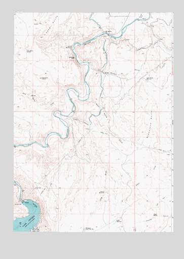
Owyhee Dam, OR USGS Topographic Map
Click on map above to begin viewing in our Map Viewer.

This topographic map contains these locations and features:
Feature Name Type Latitude Longitude GNIS ID View Map
Balancing RockPillarN43.7240°W117.2021°1117165View Map
Black Willow GulchValleyN43.7021°W117.1907°1117786View Map
Black Willow SiphonCanalN43.6957°W117.1802°1131226View Map
Blackjack ButteSummitN43.6818°W117.1496°1117790View Map
Blackjack Butte ReservoirReservoirN43.6729°W117.1529°1130100View Map
Chaney ReservoirReservoirN43.6476°W117.1787°1118819View Map
Coyote SpringSpringN43.6344°W117.1372°1119477View Map
Deer ButteSummitN43.7357°W117.2271°1136210View Map
Deer Butte SpringSpringN43.7276°W117.2403°1119806View Map
Four Points ReservoirReservoirN43.7112°W117.1462°1120918View Map
Hot SpringSpringN43.7389°W117.1785°1122059View Map
Kingman LateralCanalN43.7307°W117.1449°1122760View Map
Long DrawValleyN43.6915°W117.2063°1123411View Map
Mahogany Long Draw ReservoirReservoirN43.6272°W117.1944°1123682View Map
Oke ReservoirReservoirN43.6306°W117.1702°1124944View Map
Owyhee DamDamN43.6417°W117.2430°1125094View Map
Owyhee Dam ParkParkN43.6513°W117.2482°1130108View Map
Owyhee Lake Dam Boat RampLocaleN43.6424°W117.2347°2700040View Map
Owyhee SiphonCanalN43.7360°W117.1774°1131225View Map
Pinnacle PointSummitN43.7124°W117.2277°1125422View Map
Sand Hollow CreekStreamN43.7007°W117.2060°1126565View Map
Snively GulchValleyN43.7182°W117.1904°1127161View Map
Snively Hot SpringSpringN43.7300°W117.2042°1127162View Map
Snively SiphonCanalN43.7165°W117.1829°1131224View Map
Tunnel CanyonValleyN43.6904°W117.2035°1128295View Map
Tunnel Number 1TunnelN43.6749°W117.1996°1151517View Map
Tunnel Number 3TunnelN43.7021°W117.1816°1128300View Map
Tunnel Number 5TunnelN43.6802°W117.1754°1128302View Map

Note: Coordinates in the location and feature list above are referenced to NAD83 datum.


Copyright (C) 2008-2024 Ryan Niemi / Sunset Dynamics ... All Rights Reserved