TopoQuest Logo
Do you find TopoQuest useful?
Help keep TopoQuest running and adding new maps/features by donating!
Bitcoin:  19c7KJd3qBynnjoSw5npx9KScwjBe4ifkT
Litecoin:  LXs6TkuXGGXo1vDsWCkWVdjQX94eUKd6ui
Home View Maps Find Maps Find Places Resources & Links


Oxbow Bridge, California Topographic Map

USGS Map Title: Oxbow Bridge, CA
USGS Map MRC: 40122B5
DRG (GeoTIFF) Download: o40122b5.tif


Neighboring USGS Topographic Map Quads:


  Chickabally Mountain, CA  
40122C5
 

  Mitchell Gulch, CA  
40122C4
 

  Cold Fork, CA  
40122B6
 

  Oxbow Bridge, CA  
40122B5
 

  Blossom, CA  
40122B4
 

  Raglin Ridge, CA  
40122A6
 

  Lowrey, CA  
40122A5
 

  Red Bank, CA  
40122A4


Map MRC Location:

N41°
W123°
N41°
W122°
H8 H7 H6 H5 H4 H3 H2 H1
G8 G7 G6 G5 G4 G3 G2 G1
F8 F7 F6 F5 F4 F3 F2 F1
E8 E7 E6 E5 E4 E3 E2 E1
D8 D7 D6 D5 D4 D3 D2 D1
C8 C7 C6 C5 C4 C3 C2 C1
B8 B7 B6 B5 B4 B3 B2 B1
A8 A7 A6 A5 A4 A3 A2 A1
N40°
W123°
N40°
W122°

Oxbow Bridge, CA USGS 1:24K Topographic Map Preview:
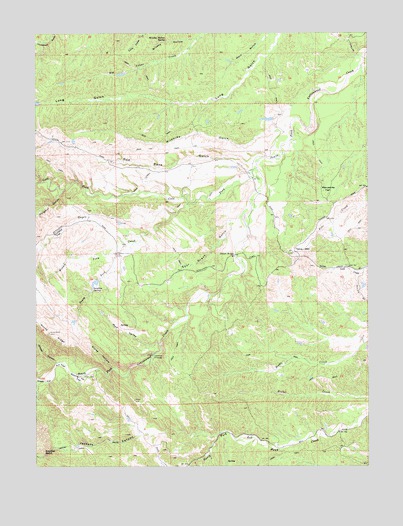
Oxbow Bridge, CA USGS Topographic Map
Click on map above to begin viewing in our Map Viewer.

This topographic map contains these locations and features:
Feature Name Type Latitude Longitude GNIS ID View Map
Ant FlatFlatN40.1540°W122.6172°218292View Map
Boulder PointCapeN40.1288°W122.6228°219699View Map
Brushy HollowValleyN40.2499°W122.5633°219950View Map
Brushy Hollow SpringSpringN40.2477°W122.5781°219952View Map
Cold ForkStreamN40.2110°W122.5433°258536View Map
Cracker CanyonValleyN40.1552°W122.6189°258858View Map
Deadman CrossingCrossingN40.1574°W122.5822°1658382View Map
Dipping Vat FlatFlatN40.1507°W122.6097°222409View Map
Fowler PlacePopulated PlaceN40.2021°W122.5606°1666613View Map
Gilliam PlacePopulated PlaceN40.1371°W122.5881°1666614View Map
Guyre CreekStreamN40.2010°W122.5692°260993View Map
Hatfield Place (historical)Populated PlaceN40.2046°W122.5703°1666615View Map
Hercraff PlacePopulated PlaceN40.2082°W122.5458°1666617View Map
Irish Place (historical)Populated PlaceN40.1310°W122.5350°1666619View Map
Jackass CanyonValleyN40.1343°W122.5870°261856View Map
Manzanita FlatFlatN40.2057°W122.5161°228038View Map
McCartney PlacePopulated PlaceN40.1740°W122.5617°1666624View Map
Middle Fork Guyre CreekStreamN40.1890°W122.5900°228595View Map
Mud ValleyValleyN40.1604°W122.5803°229275View Map
Oxbow BridgeBridgeN40.1860°W122.5517°252046View Map
Pete Hoff PlacePopulated PlaceN40.2171°W122.6108°1666628View Map
Red Bank GulchValleyN40.2124°W122.5467°231311View Map
Scofield FlatFlatN40.1927°W122.6167°232706View Map
Sour Grass GulchValleyN40.1946°W122.5542°234915View Map
South Fork Guyre CreekStreamN40.1854°W122.5958°235011View Map
Steep HollowValleyN40.1540°W122.5986°235431View Map
Sulphur GulchValleyN40.2035°W122.6170°267899View Map
Sulphur SpringSpringN40.1760°W122.6050°235725View Map
Swain PlacePopulated PlaceN40.1782°W122.5770°1666632View Map
Table MountainSummitN40.1868°W122.5297°235960View Map
Walker Place (historical)Populated PlaceN40.2154°W122.5383°1666635View Map
Wildhide GulchValleyN40.2218°W122.5364°237813View Map

Note: Coordinates in the location and feature list above are referenced to NAD83 datum.


Copyright (C) 2008-2025 Ryan Niemi / Sunset Dynamics ... All Rights Reserved