TopoQuest Logo
Do you find TopoQuest useful?
Help keep TopoQuest running and adding new maps/features by donating!
Bitcoin:  19c7KJd3qBynnjoSw5npx9KScwjBe4ifkT
Litecoin:  LXs6TkuXGGXo1vDsWCkWVdjQX94eUKd6ui
Home View Maps Find Maps Find Places Resources & Links


Oxford North, Mississippi Topographic Map

USGS Map Title: Oxford North, MS
USGS Map MRC: 34089D5
DRG (GeoTIFF) Download: o34089d5.tif


Neighboring USGS Topographic Map Quads:


  Tyro, MS  
34089E6
 

  Laws Hill, MS  
34089E5
 

  Malone, MS  
34089E4
 

  Coles Point, MS  
34089D6
 

  Oxford North, MS  
34089D5
 

  Bagley Lake, MS  
34089D4
 

  Splinter, MS  
34089C6
 

  Oxford South, MS  
34089C5
 

  Yocona, MS  
34089C4


Map MRC Location:

N35°
W90°
N35°
W89°
H8 H7 H6 H5 H4 H3 H2 H1
G8 G7 G6 G5 G4 G3 G2 G1
F8 F7 F6 F5 F4 F3 F2 F1
E8 E7 E6 E5 E4 E3 E2 E1
D8 D7 D6 D5 D4 D3 D2 D1
C8 C7 C6 C5 C4 C3 C2 C1
B8 B7 B6 B5 B4 B3 B2 B1
A8 A7 A6 A5 A4 A3 A2 A1
N34°
W90°
N34°
W89°

Oxford North, MS USGS 1:24K Topographic Map Preview:
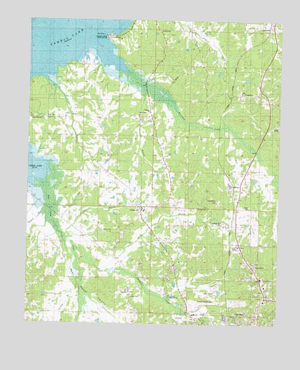
Oxford North, MS USGS Topographic Map
Click on map above to begin viewing in our Map Viewer.

This topographic map contains these locations and features:
Feature Name Type Latitude Longitude GNIS ID View Map
Berry BranchStreamN34.4104°W89.6101°666848View Map
Bishop Place (historical)LocaleN34.4948°W89.6051°684335View Map
Bishop Store (historical)LocaleN34.4812°W89.5987°684336View Map
Buford CemeteryCemeteryN34.4601°W89.6165°684340View Map
Buford ChapelChurchN34.4604°W89.6204°667764View Map
Buford ChapelChurchN34.4134°W89.5868°684341View Map
Bufords Store (historical)LocaleN34.4112°W89.6043°684342View Map
Cataract BranchStreamN34.4112°W89.6101°668156View Map
College HillPopulated PlaceN34.4218°W89.5706°668694View Map
College Hill CemeteryCemeteryN34.4229°W89.5704°706722View Map
College Hill HeightsPopulated PlaceN34.3973°W89.5529°684355View Map
College Hill Presbyterian ChurchChurchN34.4232°W89.5698°684356View Map
College Hill StationLocaleN34.4159°W89.5212°668697View Map
Dunlap BranchStreamN34.4718°W89.5690°669513View Map
East Goose ValleyValleyN34.4173°W89.6124°669582View Map
Galloway Pond DamDamN34.4034°W89.6118°682632View Map
Goose CreekStreamN34.3857°W89.5962°684374View Map
Hammitt Hill ChurchChurchN34.3993°W89.5112°684378View Map
Hamrick Hill Church (historical)ChurchN34.4037°W89.5165°684379View Map
Hurricane CreekStreamN34.4998°W89.5956°693572View Map
Hurricane Landing Public Use AreaParkN34.4932°W89.5862°684383View Map
Jack McCormick Pond DamDamN34.3801°W89.5968°682615View Map
Johnson Pond DamDamN34.4201°W89.5801°682634View Map
Jordan ChurchChurchN34.4165°W89.5915°672019View Map
Lafayette County Volunteer Fire Department Station 10 HeadquartersBuildingN34.4075°W89.5105°2665998View Map
Lafayette County Volunteer Fire Department Station 4BuildingN34.4212°W89.5670°2665996View Map
Lafayette County Volunteer Fire Department Station 7BuildingN34.4968°W89.5044°2665995View Map
Lakeway GardensPopulated PlaceN34.3904°W89.5551°684387View Map
Liberty Hill ChurchChurchN34.4807°W89.5387°672468View Map
Logan SchoolSchoolN34.4962°W89.5631°672770View Map
Molly Barr CovePopulated PlaceN34.3812°W89.5279°684396View Map
North Oxford Baptist ChurchChurchN34.3940°W89.5084°684403View Map
North Oxford CemeteryCemeteryN34.3932°W89.5081°1805873View Map
Oxford Police DepartmentBuildingN34.3760°W89.5273°2754163View Map
Oxford Post OfficePost OfficeN34.3808°W89.5324°2768609View Map
Paine Pond DamDamN34.4001°W89.5017°682630View Map
Pine Grove CemeteryCemeteryN34.4237°W89.6040°706741View Map
Pine Grove ChurchChurchN34.4184°W89.6062°675854View Map
Pine Grove SchoolSchoolN34.4537°W89.5648°675856View Map
Pine Grove School (historical)SchoolN34.4173°W89.6037°684423View Map
Plants BranchStreamN34.4232°W89.6151°684424View Map
Providence Church (historical)ChurchN34.4957°W89.5609°684426View Map
Rieves Store (historical)LocaleN34.4354°W89.5829°684430View Map
Saddlers HillSummitN34.4265°W89.5323°676995View Map
Saint John ChurchChurchN34.4593°W89.5640°684435View Map
Saint John Church (historical)ChurchN34.4820°W89.5809°684434View Map
Saint Johns CemeteryCemeteryN34.4904°W89.5831°677073View Map
Saint Peter CemeteryCemeteryN34.4959°W89.5604°684439View Map
Saint Peter Church (historical)ChurchN34.4254°W89.5442°684440View Map
Springfield Missionary Baptist ChurchChurchN34.4704°W89.5195°678177View Map
State Migratory Waterfowl RefugeParkN34.4834°W89.5904°684451View Map
Supervisor District 3CivilN34.4268°W89.5915°711930View Map
Tara EstatesPopulated PlaceN34.4037°W89.5501°684454View Map
Toby Tubby CemeteryCemeteryN34.4601°W89.5387°684458View Map
Toby Tubby School (historical)SchoolN34.4612°W89.6206°684460View Map
University-Oxford AirportAirportN34.3831°W89.5396°680431View Map
Waller Pond DamDamN34.3751°W89.5884°682611View Map
West Goose ValleyValleyN34.3826°W89.5972°679493View Map

Note: Coordinates in the location and feature list above are referenced to NAD83 datum.


Copyright (C) 2008-2025 Ryan Niemi / Sunset Dynamics ... All Rights Reserved