TopoQuest Logo
Do you find TopoQuest useful?
Help keep TopoQuest running and adding new maps/features by donating!
Bitcoin:  19c7KJd3qBynnjoSw5npx9KScwjBe4ifkT
Litecoin:  LXs6TkuXGGXo1vDsWCkWVdjQX94eUKd6ui
Home View Maps Find Maps Find Places Resources & Links


Yocona, Mississippi Topographic Map

USGS Map Title: Yocona, MS
USGS Map MRC: 34089C4
DRG (GeoTIFF) Download: o34089c4.tif


Neighboring USGS Topographic Map Quads:


  Oxford North, MS  
34089D5
 

  Bagley Lake, MS  
34089D4
 

  Puskus Lake, MS  
34089D3
 

  Oxford South, MS  
34089C5
 

  Yocona, MS  
34089C4
 

  Denmark, MS  
34089C3
 

  Water Valley East, MS  
34089B5
 

  Paris, MS  
34089B4
 

  Tula, MS  
34089B3


Map MRC Location:

N35°
W90°
N35°
W89°
H8 H7 H6 H5 H4 H3 H2 H1
G8 G7 G6 G5 G4 G3 G2 G1
F8 F7 F6 F5 F4 F3 F2 F1
E8 E7 E6 E5 E4 E3 E2 E1
D8 D7 D6 D5 D4 D3 D2 D1
C8 C7 C6 C5 C4 C3 C2 C1
B8 B7 B6 B5 B4 B3 B2 B1
A8 A7 A6 A5 A4 A3 A2 A1
N34°
W90°
N34°
W89°

Yocona, MS USGS 1:24K Topographic Map Preview:
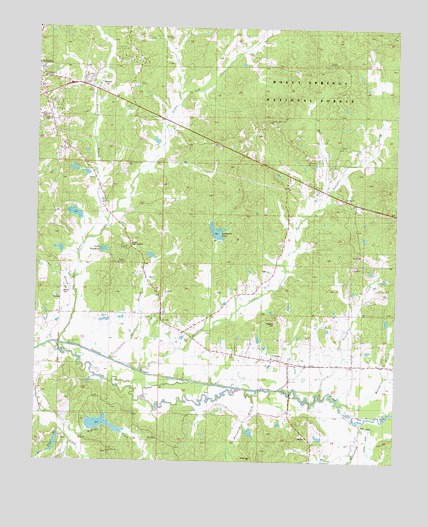
Yocona, MS USGS Topographic Map
Click on map above to begin viewing in our Map Viewer.

This topographic map contains these locations and features:
Feature Name Type Latitude Longitude GNIS ID View Map
AltusPopulated PlaceN34.3409°W89.3962°692390View Map
Apostles Movement ChurchChurchN34.3482°W89.4195°704813View Map
Ave DitchCanalN34.2601°W89.3834°692429View Map
Bethel ChurchChurchN34.3359°W89.4067°692563View Map
Bowles CemeteryCemeteryN34.2993°W89.4898°704818View Map
Brittany WoodsPopulated PlaceN34.3598°W89.4823°704819View Map
Burney BranchStreamN34.2832°W89.4976°692774View Map
Camp Lake StevensLocaleN34.3112°W89.4695°704823View Map
Cantral Bridge (historical)BridgeN34.2837°W89.4920°704824View Map
Cat Hair CreekStreamN34.3246°W89.3995°692857View Map
Center Church (historical)ChurchN34.3590°W89.4679°704826View Map
East Oxford ChurchChurchN34.3354°W89.4687°704839View Map
East Providence SchoolSchoolN34.3059°W89.4529°693152View Map
Fourmile BranchStreamN34.3193°W89.4756°693257View Map
Fox CreekStreamN34.2871°W89.4654°704842View Map
Gault BranchStreamN34.2529°W89.3895°693289View Map
Gooch BranchStreamN34.2990°W89.4873°693313View Map
Hartsfield BranchStreamN34.2682°W89.4245°693428View Map
Indian Mound School (historical)SchoolN34.3290°W89.4040°704847View Map
Kingdom CemeteryCemeteryN34.2904°W89.4167°704853View Map
Lafayette CountyCivilN34.3568°W89.4849°695759View Map
Lafayette County Volunteer Fire Department Station 5BuildingN34.2792°W89.4164°2665911View Map
Lafayette High SchoolSchoolN34.3487°W89.4981°704855View Map
Lafayette LakeReservoirN34.3167°W89.4378°693677View Map
Lafayette Lake DamDamN34.3134°W89.4384°695565View Map
Lester DitchCanalN34.2504°W89.3851°693711View Map
Linder Pond DamDamN34.3201°W89.4851°695567View Map
Linkers Mill (historical)LocaleN34.3459°W89.4531°704858View Map
Lizard CreekStreamN34.2698°W89.4031°693798View Map
Lusk Store (historical)LocaleN34.2851°W89.4245°704860View Map
McCaine CreekStreamN34.2604°W89.4892°693902View Map
McGonigal CemeteryCemeteryN34.2512°W89.4242°693919View Map
Midway ChurchChurchN34.3326°W89.3751°693960View Map
Midway CHurchChurchN34.3257°W89.3931°705635View Map
Monroe BranchStreamN34.2668°W89.3942°694019View Map
Morris Store (historical)LocaleN34.3173°W89.4967°704867View Map
Mount Zion CemeteryCemeteryN34.3704°W89.4537°706730View Map
Mount Zion ChurchChurchN34.3729°W89.4540°694119View Map
Murray Creek Y-13a-1 DamDamN34.2668°W89.4667°695560View Map
New Prospect Church (historical)ChurchN34.2843°W89.3984°704868View Map
New York SchoolSchoolN34.3718°W89.3806°694191View Map
Oliver BridgeBridgeN34.2693°W89.4112°704871View Map
Ox BranchStreamN34.2793°W89.4742°704873View Map
Pine Flat BranchStreamN34.2582°W89.4912°694374View Map
PortertonPopulated PlaceN34.2882°W89.4515°704879View Map
Potlockney CreekStreamN34.2623°W89.3890°694462View Map
Providence Church (historical)ChurchN34.3057°W89.4517°704881View Map
Pumpkin CreekStreamN34.2771°W89.4645°694491View Map
Ragland Store (historical)LocaleN34.3012°W89.4604°704883View Map
Rameys Chapel (historical)ChurchN34.3065°W89.4623°704884View Map
Rolling WoodsPopulated PlaceN34.3529°W89.4770°704885View Map
Rollings WoodsPopulated PlaceN34.3529°W89.4937°704886View Map
Sand HillSummitN34.3362°W89.4840°704888View Map
Stephens LakeReservoirN34.3110°W89.4763°704896View Map
Tarvers CreekStreamN34.2559°W89.4873°694944View Map
Tatum Pond DamDamN34.3334°W89.4851°695570View Map
Union Grove ChurchChurchN34.2529°W89.4748°693378View Map
Yellow Leaf CemeteryCemeteryN34.3057°W89.4706°706752View Map
Yellow Leaf CreekStreamN34.2837°W89.4917°695226View Map
Yellowleaf Baptist ChurchChurchN34.3071°W89.4715°704906View Map
YoconaPopulated PlaceN34.2782°W89.4148°695229View Map
Yocona High School (historical)SchoolN34.2787°W89.4167°706753View Map

Note: Coordinates in the location and feature list above are referenced to NAD83 datum.


Copyright (C) 2008-2024 Ryan Niemi / Sunset Dynamics ... All Rights Reserved