TopoQuest Logo
Do you find TopoQuest useful?
Help keep TopoQuest running and adding new maps/features by donating!
Bitcoin:  19c7KJd3qBynnjoSw5npx9KScwjBe4ifkT
Litecoin:  LXs6TkuXGGXo1vDsWCkWVdjQX94eUKd6ui
Home View Maps Find Maps Find Places Resources & Links


Laws Hill, Mississippi Topographic Map

USGS Map Title: Laws Hill, MS
USGS Map MRC: 34089E5
DRG (GeoTIFF) Download: o34089e5.tif


Neighboring USGS Topographic Map Quads:


  Wyatte, MS  
34089F6
 

  Marianna, MS  
34089F5
 

  Waterford, MS  
34089F4
 

  Tyro, MS  
34089E6
 

  Laws Hill, MS  
34089E5
 

  Malone, MS  
34089E4
 

  Coles Point, MS  
34089D6
 

  Oxford North, MS  
34089D5
 

  Bagley Lake, MS  
34089D4


Map MRC Location:

N35°
W90°
N35°
W89°
H8 H7 H6 H5 H4 H3 H2 H1
G8 G7 G6 G5 G4 G3 G2 G1
F8 F7 F6 F5 F4 F3 F2 F1
E8 E7 E6 E5 E4 E3 E2 E1
D8 D7 D6 D5 D4 D3 D2 D1
C8 C7 C6 C5 C4 C3 C2 C1
B8 B7 B6 B5 B4 B3 B2 B1
A8 A7 A6 A5 A4 A3 A2 A1
N34°
W90°
N34°
W89°

Laws Hill, MS USGS 1:24K Topographic Map Preview:
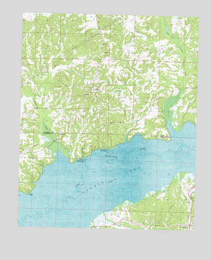
Laws Hill, MS USGS Topographic Map
Click on map above to begin viewing in our Map Viewer.

This topographic map contains these locations and features:
Feature Name Type Latitude Longitude GNIS ID View Map
AbbevillePopulated PlaceN34.5032°W89.5031°691642View Map
Abbeville CemeteryCemeteryN34.5165°W89.5026°666125View Map
Abbeville Post OfficePost OfficeN34.5028°W89.5017°2768613View Map
Abbeville School (historical)SchoolN34.5051°W89.5017°706717View Map
Alexander CemeteryCemeteryN34.5940°W89.6020°666184View Map
Bible Way ChurchChurchN34.5179°W89.5037°667068View Map
BlackwaterPopulated PlaceN34.5554°W89.5968°691708View Map
Blackwater CreekStreamN34.5457°W89.5981°667255View Map
Dunnovants Ferry (historical)CrossingN34.5501°W89.5076°684362View Map
Gallegley Store (historical)LocaleN34.5034°W89.5548°684372View Map
Graham Lake (historical)LakeN34.5334°W89.5417°684375View Map
Harris ChapelChurchN34.5845°W89.5726°683807View Map
Laws HillPopulated PlaceN34.5795°W89.5740°672329View Map
Laws Hill School (historical)SchoolN34.5837°W89.5731°683822View Map
Laws Hill School (historical)SchoolN34.5782°W89.5765°683823View Map
Mount Comfort CemeteryCemeteryN34.5982°W89.5451°1959770View Map
Mount Comfort Christian Methodist Episcopal ChurchChurchN34.5987°W89.5448°673977View Map
Mount Comfort School (historical)SchoolN34.5984°W89.5456°683830View Map
Mount Maria Church (historical)ChurchN34.6068°W89.5681°683831View Map
Mount Moriah CemeteryCemeteryN34.6076°W89.5684°674058View Map
Mount Moriah ChurchChurchN34.6026°W89.5667°674083View Map
Mount Vernon ChurchChurchN34.5182°W89.5020°674309View Map
Mount Vernon School (historical)SchoolN34.5173°W89.5015°684397View Map
New Hope CemeteryCemeteryN34.5620°W89.5615°674671View Map
New Hope CemeteryCemeteryN34.5773°W89.5779°1959772View Map
New Hope ChurchChurchN34.5776°W89.5773°674742View Map
New Hope Church (historical)ChurchN34.5557°W89.5665°683838View Map
Newsom CreekStreamN34.5551°W89.5492°674912View Map
Oak Chewalla CreekStreamN34.5654°W89.5195°675005View Map
Pauls Chapel (historical)ChurchN34.6007°W89.5417°683844View Map
Peel CemeteryCemeteryN34.6165°W89.5695°675571View Map
Pigeon Roost Watershed Y-5-124 DamDamN34.6201°W89.5784°682741View Map
Piney PointCapeN34.5187°W89.6179°675906View Map
Redmans Bluff Public Use AreaParkN34.5468°W89.5654°676551View Map
Smith School (historical)SchoolN34.5537°W89.5726°684445View Map
Smith Store (historical)LocaleN34.5534°W89.5792°684446View Map
Town of AbbevilleCivilN34.5034°W89.5025°2405117View Map
Turner CreekStreamN34.5537°W89.5495°678975View Map
Wyatt (historical)LocaleN34.5459°W89.5765°706751View Map
Wyatt Bridge (historical)BridgeN34.5398°W89.5781°684472View Map
Wyatt CemeteryCemeteryN34.5484°W89.5737°679899View Map
Wyatt Crossing Public Use AreaParkN34.5404°W89.5845°679901View Map

Note: Coordinates in the location and feature list above are referenced to NAD83 datum.


Copyright (C) 2008-2025 Ryan Niemi / Sunset Dynamics ... All Rights Reserved