TopoQuest Logo
Do you find TopoQuest useful?
Help keep TopoQuest running and adding new maps/features by donating!
Bitcoin:  19c7KJd3qBynnjoSw5npx9KScwjBe4ifkT
Litecoin:  LXs6TkuXGGXo1vDsWCkWVdjQX94eUKd6ui
Home View Maps Find Maps Find Places Resources & Links


Palacios NE, Texas Topographic Map

USGS Map Title: Palacios NE, TX
USGS Map MRC: 28096F1
DRG (GeoTIFF) Download: o28096f1.tif


Neighboring USGS Topographic Map Quads:


  Blessing, TX  
28096G2
 

  Blessing SE, TX  
28096G1
 

  Wadsworth, TX  
28095G8
 

  Palacios, TX  
28096F2
 

  Palacios NE, TX  
28096F1
 

  Matagorda, TX  
28095F8
 

  Palacios Point, TX  
28096E2
 

  Palacios SE, TX  
28096E1
 

  Matagorda SW, TX  
28095E8


Map MRC Location:

N29°
W97°
N29°
W96°
H8 H7 H6 H5 H4 H3 H2 H1
G8 G7 G6 G5 G4 G3 G2 G1
F8 F7 F6 F5 F4 F3 F2 F1
E8 E7 E6 E5 E4 E3 E2 E1
D8 D7 D6 D5 D4 D3 D2 D1
C8 C7 C6 C5 C4 C3 C2 C1
B8 B7 B6 B5 B4 B3 B2 B1
A8 A7 A6 A5 A4 A3 A2 A1
N28°
W97°
N28°
W96°

Palacios NE, TX USGS 1:24K Topographic Map Preview:
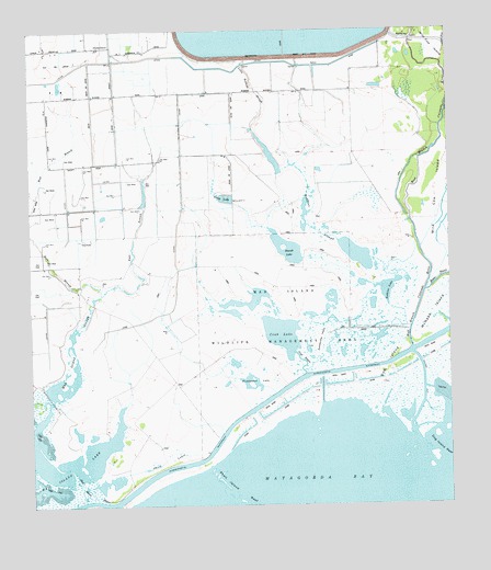
Palacios NE, TX USGS Topographic Map
Click on map above to begin viewing in our Map Viewer.

This topographic map contains these locations and features:
Feature Name Type Latitude Longitude GNIS ID View Map
Citrus GrovePopulated PlaceN28.7475°W96.1058°2035020View Map
Citrus Grove SchoolLocaleN28.7461°W96.1050°1354518View Map
Cooling Water Reservoir DamDamN28.7436°W96.0586°1865496View Map
Crab BayouChannelN28.6633°W96.0439°1355290View Map
Crab LakeLakeN28.6701°W96.0502°1355291View Map
Culver CutChannelN28.6839°W96.0036°1381028View Map
Dog IslandIslandN28.6611°W96.0180°1356121View Map
East Branch Mad Island SloughStreamN28.6822°W96.1027°1356576View Map
Freshwater LakeLakeN28.6576°W96.0578°1357731View Map
Gillett LakeReservoirN28.7055°W96.0633°1358023View Map
Little Robbins SloughStreamN28.7058°W96.0480°1361448View Map
Mad Island BayouChannelN28.6278°W96.1083°1362045View Map
Mad Island LakeLakeN28.6361°W96.1170°1362046View Map
Mad Island SloughStreamN28.6503°W96.1191°1362048View Map
Mad Island Wildlife Management AreaParkN28.6630°W96.0050°2029861View Map
McNabb IslandIslandN28.6761°W96.0036°1362522View Map
Rattlesnake IslandIslandN28.6694°W96.0380°1366044View Map
Robbins LakeLakeN28.6820°W96.0184°1366570View Map
Robbins SloughSwampN28.6809°W96.0363°1366571View Map
Shell Island ReefBarN28.6255°W96.0586°1368111View Map
Shell LakesLakeN28.6369°W96.0844°1368112View Map
West Branch Mad Island SloughStreamN28.6967°W96.1250°1371077View Map

Note: Coordinates in the location and feature list above are referenced to NAD83 datum.


Copyright (C) 2008-2024 Ryan Niemi / Sunset Dynamics ... All Rights Reserved