TopoQuest Logo
Do you find TopoQuest useful?
Help keep TopoQuest running and adding new maps/features by donating!
Bitcoin:  19c7KJd3qBynnjoSw5npx9KScwjBe4ifkT
Litecoin:  LXs6TkuXGGXo1vDsWCkWVdjQX94eUKd6ui
Home View Maps Find Maps Find Places Resources & Links


Palacios, Texas Topographic Map

USGS Map Title: Palacios, TX
USGS Map MRC: 28096F2
DRG (GeoTIFF) Download: o28096f2.tif


Neighboring USGS Topographic Map Quads:


  Francitas, TX  
28096G3
 

  Blessing, TX  
28096G2
 

  Blessing SE, TX  
28096G1
 

  Turtle Bay, TX  
28096F3
 

  Palacios, TX  
28096F2
 

  Palacios NE, TX  
28096F1
 

  Carancahua Pass, TX  
28096E3
 

  Palacios Point, TX  
28096E2
 

  Palacios SE, TX  
28096E1


Map MRC Location:

N29°
W97°
N29°
W96°
H8 H7 H6 H5 H4 H3 H2 H1
G8 G7 G6 G5 G4 G3 G2 G1
F8 F7 F6 F5 F4 F3 F2 F1
E8 E7 E6 E5 E4 E3 E2 E1
D8 D7 D6 D5 D4 D3 D2 D1
C8 C7 C6 C5 C4 C3 C2 C1
B8 B7 B6 B5 B4 B3 B2 B1
A8 A7 A6 A5 A4 A3 A2 A1
N28°
W97°
N28°
W96°

Palacios, TX USGS 1:24K Topographic Map Preview:
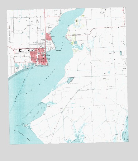
Palacios, TX USGS Topographic Map
Click on map above to begin viewing in our Map Viewer.

This topographic map contains these locations and features:
Feature Name Type Latitude Longitude GNIS ID View Map
Camp HulenPopulated PlaceN28.7067°W96.2433°1353644View Map
Central Elementary SchoolSchoolN28.7091°W96.2175°2007742View Map
Church of ChristChurchN28.7125°W96.2172°2022426View Map
Church of God of ProphecyChurchN28.7039°W96.2152°2022427View Map
CollegeportPopulated PlaceN28.7253°W96.1750°1379577View Map
Collegeport CemeteryCemeteryN28.7417°W96.1683°1354788View Map
Collegeport Post OfficePost OfficeN28.7248°W96.1782°2732138View Map
Coon IslandIslandN28.6522°W96.2314°1354930View Map
Coon Island BayBayN28.6561°W96.2172°1354931View Map
East Bay Yacht Harbor MarinaLocaleN28.7111°W96.2100°2030510View Map
Eastside Elementary SchoolSchoolN28.7080°W96.2128°2007745View Map
First Baptist ChurchChurchN28.7014°W96.2122°2022421View Map
Grassy PointCapeN28.7122°W96.1986°1358318View Map
Matagorda County Alternative School - PalaciosSchoolN28.7116°W96.2272°2007643View Map
Matagorda County Constable's Office Precinct 3BuildingN28.7002°W96.2155°2334999View Map
Matagorda County Emergency Medical ServicesBuildingN28.7163°W96.2147°2656036View Map
Oliver PointCapeN28.6430°W96.2372°1364528View Map
PalaciosPopulated PlaceN28.7080°W96.2175°1364710View Map
Palacios Area Historical AssociationBuildingN28.7003°W96.2175°2032314View Map
Palacios City HallBuildingN28.7133°W96.2141°2753583View Map
Palacios Community Medical CenterHospitalN28.7170°W96.2142°2015765View Map
Palacios DivisionCivilN28.6625°W96.1854°1939069View Map
Palacios High SchoolSchoolN28.7117°W96.2370°2007647View Map
Palacios Junior High SchoolSchoolN28.7130°W96.2369°2007648View Map
Palacios Police DepartmentBuildingN28.7002°W96.2156°2739434View Map
Palacios Post OfficePost OfficeN28.7145°W96.2193°2731633View Map
Palacios Volunteer Fire DepartmentBuildingN28.7006°W96.2154°2334263View Map
Pelican SloughStreamN28.7144°W96.1823°1365019View Map
Pepper HillSummitN28.7358°W96.1758°1365055View Map
Pilgrim Rose Baptist ChurchChurchN28.7050°W96.2222°2022422View Map
Saint Anthonys Catholic ChurchChurchN28.7114°W96.2239°2022425View Map
Saint Johns Episcopal ChurchChurchN28.7017°W96.2136°2022428View Map
Solid Rock Fellowship ChurchChurchN28.7192°W96.2105°2022430View Map
Texas Baptist Encampment ChurchChurchN28.6992°W96.2105°2022423View Map
Tres Palacios BayBayN28.6789°W96.2191°1370103View Map
Trinity Baptist ChurchChurchN28.7114°W96.2119°2022424View Map
Trull AirportAirportN28.7392°W96.2191°1387278View Map
United Pentecostal ChurchChurchN28.7047°W96.2105°2022429View Map
Wagner HeliportAirportN28.7164°W96.2141°1387282View Map

Note: Coordinates in the location and feature list above are referenced to NAD83 datum.


Copyright (C) 2008-2025 Ryan Niemi / Sunset Dynamics ... All Rights Reserved