TopoQuest Logo
Do you find TopoQuest useful?
Help keep TopoQuest running and adding new maps/features by donating!
Bitcoin:  19c7KJd3qBynnjoSw5npx9KScwjBe4ifkT
Litecoin:  LXs6TkuXGGXo1vDsWCkWVdjQX94eUKd6ui
Home View Maps Find Maps Find Places Resources & Links


Razorville, Maine Topographic Map

USGS Map Title: Razorville, ME
USGS Map MRC: 44069C4
DRG (GeoTIFF) Download: o44069c4.tif


Neighboring USGS Topographic Map Quads:


  China Lake, ME  
44069D5
 

  Palermo, ME  
44069D4
 

  Liberty, ME  
44069D3
 

  Weeks Mills, ME  
44069C5
 

  Razorville, ME  
44069C4
 

  Washington, ME  
44069C3
 

  North Whitefield, ME  
44069B5
 

  Jefferson, ME  
44069B4
 

  Union, ME  
44069B3


Map MRC Location:

N45°
W70°
N45°
W69°
H8 H7 H6 H5 H4 H3 H2 H1
G8 G7 G6 G5 G4 G3 G2 G1
F8 F7 F6 F5 F4 F3 F2 F1
E8 E7 E6 E5 E4 E3 E2 E1
D8 D7 D6 D5 D4 D3 D2 D1
C8 C7 C6 C5 C4 C3 C2 C1
B8 B7 B6 B5 B4 B3 B2 B1
A8 A7 A6 A5 A4 A3 A2 A1
N44°
W70°
N44°
W69°

Razorville, ME USGS 1:24K Topographic Map Preview:
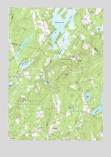
Razorville, ME USGS Topographic Map
Click on map above to begin viewing in our Map Viewer.

This topographic map contains these locations and features:
Feature Name Type Latitude Longitude GNIS ID View Map
Colby BrookStreamN44.3409°W69.4245°564172View Map
Colby Mills DamDamN44.3282°W69.4912°1773997View Map
Colby PondLakeN44.3553°W69.3811°564175View Map
Crummett BrookStreamN44.2815°W69.4989°564628View Map
Crummett MountainSummitN44.2887°W69.4787°564629View Map
Crystal PondLakeN44.2915°W69.3949°564637View Map
Cunningham MountainSummitN44.3248°W69.4095°564662View Map
Deadwater SloughGutN44.3429°W69.4273°564911View Map
East PalermoPopulated PlaceN44.3704°W69.3917°579280View Map
East Palermo CemeteryCemeteryN44.3707°W69.3920°2737052View Map
Eastman CemeteryCemeteryN44.3292°W69.4214°1909780View Map
Gove CemeteryCemeteryN44.3340°W69.3773°567008View Map
Hannan CemeteryCemeteryN44.3592°W69.3934°567567View Map
Hibberts CornerPopulated PlaceN44.3042°W69.4073°579402View Map
Hibberts GoreCivilN44.3259°W69.4276°582518View Map
Howard CemeteryCemeteryN44.2992°W69.4220°568378View Map
James PondLakeN44.3231°W69.4797°568762View Map
Jones BrookStreamN44.3112°W69.4545°568947View Map
Jones CornerPopulated PlaceN44.2609°W69.4600°579438View Map
Jones CornerPopulated PlaceN44.3645°W69.3981°579439View Map
Lenfest CemeteryCemeteryN44.3438°W69.4029°569480View Map
Linscott BranchStreamN44.3720°W69.4256°569638View Map
Marrs HillSummitN44.3239°W69.4454°570796View Map
Muddy PondLakeN44.2808°W69.4159°571962View Map
Palermo Community LibraryBuildingN44.3715°W69.3944°2738514View Map
Palermo Volunteer Fire Department East Palermo StationBuildingN44.3613°W69.4013°2553137View Map
Patrick MountainSummitN44.3119°W69.4267°573054View Map
RazorvillePopulated PlaceN44.2765°W69.3970°574066View Map
Sand Hill CemeteryCemeteryN44.3130°W69.4545°2736832View Map
Sandhill CornerPopulated PlaceN44.3098°W69.4581°579674View Map
Sandhill SchoolSchoolN44.3137°W69.4548°574863View Map
Sheepscot PondReservoirN44.3615°W69.4304°575362View Map
Sheepscot Pond DamDamN44.3387°W69.4424°1774332View Map
SomervillePopulated PlaceN44.3092°W69.4889°575719View Map
Somerville Elementary SchoolSchoolN44.3041°W69.4503°1909958View Map
Somerville Fire StationBuildingN44.2608°W69.4582°2735793View Map
Somerville Town LibraryBuildingN44.3039°W69.4501°2738484View Map
Town of SomervilleCivilN44.2896°W69.4777°582729View Map
Town of WashingtonCivilN44.2734°W69.3911°582792View Map
Turner BranchStreamN44.3465°W69.4770°577416View Map
Turner PondReservoirN44.3394°W69.4782°577435View Map
West WashingtonPopulated PlaceN44.2609°W69.4409°579826View Map

Note: Coordinates in the location and feature list above are referenced to NAD83 datum.


Copyright (C) 2008-2024 Ryan Niemi / Sunset Dynamics ... All Rights Reserved