TopoQuest Logo
Do you find TopoQuest useful?
Help keep TopoQuest running and adding new maps/features by donating!
Bitcoin:  19c7KJd3qBynnjoSw5npx9KScwjBe4ifkT
Litecoin:  LXs6TkuXGGXo1vDsWCkWVdjQX94eUKd6ui
Home View Maps Find Maps Find Places Resources & Links


Palmerton, Pennsylvania Topographic Map

USGS Map Title: Palmerton, PA
USGS Map MRC: 40075G5
DRG (GeoTIFF) Download: o40075g5.tif


Neighboring USGS Topographic Map Quads:


  Christmans, PA  
40075H6
 

  Pohopoco Mountain, PA  
40075H5
 

  Brodheadsville, PA  
40075H4
 

  Lehighton, PA  
40075G6
 

  Palmerton, PA  
40075G5
 

  Kunkletown, PA  
40075G4
 

  Slatedale, PA  
40075F6
 

  Cementon, PA  
40075F5
 

  Catasauqua, PA  
40075F4


Map MRC Location:

N41°
W76°
N41°
W75°
H8 H7 H6 H5 H4 H3 H2 H1
G8 G7 G6 G5 G4 G3 G2 G1
F8 F7 F6 F5 F4 F3 F2 F1
E8 E7 E6 E5 E4 E3 E2 E1
D8 D7 D6 D5 D4 D3 D2 D1
C8 C7 C6 C5 C4 C3 C2 C1
B8 B7 B6 B5 B4 B3 B2 B1
A8 A7 A6 A5 A4 A3 A2 A1
N40°
W76°
N40°
W75°

Palmerton, PA USGS 1:24K Topographic Map Preview:
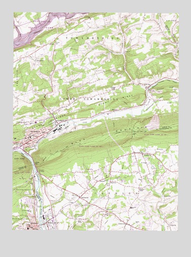
Palmerton, PA USGS Topographic Map
Click on map above to begin viewing in our Map Viewer.

This topographic map contains these locations and features:
Feature Name Type Latitude Longitude GNIS ID View Map
AppsPopulated PlaceN40.7662°W75.5816°1205022View Map
AquashicolaPopulated PlaceN40.8112°W75.5902°1168357View Map
Aquashicola CreekStreamN40.7923°W75.6124°1168358View Map
Aquashicola Post OfficePost OfficeN40.8112°W75.5907°2773066View Map
Aquashicola Volunteer Fire Company District 1BuildingN40.8126°W75.5877°2653172View Map
Ash SchoolSchoolN40.8184°W75.5632°1195948View Map
Beltzville LakeReservoirN40.8652°W75.6058°1192120View Map
Beltzville State ParkParkN40.8684°W75.6080°1198251View Map
BerlinsvillePopulated PlaceN40.7687°W75.5738°1169304View Map
Bethany TabernacleChurchN40.8576°W75.5946°1169351View Map
Borger CreekStreamN40.8362°W75.5010°1170010View Map
Borough of PalmertonCivilN40.8023°W75.6159°1215049View Map
Borough of SlatingtonCivilN40.7544°W75.6114°1215379View Map
Borough of WalnutportCivilN40.7515°W75.5957°1215505View Map
Bossards CornerPopulated PlaceN40.7745°W75.5291°1170017View Map
Buckwha CreekStreamN40.8181°W75.5274°1198048View Map
CherryvillePopulated PlaceN40.7540°W75.5385°1171691View Map
Cherryville Census Designated PlaceCensusN40.7549°W75.5309°2633339View Map
Cherryville Post OfficePost OfficeN40.7556°W75.5369°2773096View Map
Christian CornerPopulated PlaceN40.8309°W75.5494°1205034View Map
Constantini DamDamN40.8251°W75.5996°1208719View Map
Craigs Island (historical)IslandN40.7968°W75.6196°1196065View Map
DanielsvillePopulated PlaceN40.7945°W75.5271°1172923View Map
Danielsville Post OfficePost OfficeN40.7947°W75.5292°2772664View Map
Delaware Elementary SchoolSchoolN40.7995°W75.6141°1210556View Map
Devils Potato PatchAreaN40.8062°W75.5338°1201485View Map
Devils PulpitPillarN40.7893°W75.6138°1210804View Map
Diamond Fire Company Station 29BuildingN40.7537°W75.5979°2653469View Map
Dieters Airport (historical)AirportN40.7551°W75.5330°1194092View Map
Eckhardt SchoolSchoolN40.8526°W75.5507°1195947View Map
EdgemontPopulated PlaceN40.7782°W75.5510°1174006View Map
Forest InnLocaleN40.8590°W75.5932°1192476View Map
Franklin SchoolSchoolN40.8059°W75.6016°1175175View Map
Greenzweig SchoolSchoolN40.8648°W75.5288°1195946View Map
HarpersPopulated PlaceN40.7793°W75.5566°1176564View Map
HowersvillePopulated PlaceN40.7704°W75.5113°1203851View Map
Hunter CreekStreamN40.8318°W75.5213°1177607View Map
IndianlandPopulated PlaceN40.7612°W75.5535°1177800View Map
Indianola LakeReservoirN40.7774°W75.5173°1202923View Map
JonesvillePopulated PlaceN40.8520°W75.5410°1205056View Map
Kerns DamDamN40.7537°W75.6110°1208710View Map
Lehigh Canal (historical)CanalN40.7693°W75.6035°1192763View Map
Lehigh GapGapN40.7870°W75.6074°1192765View Map
Lehigh GapPopulated PlaceN40.7768°W75.6082°1192766View Map
Lehigh Gap SchoolSchoolN40.7818°W75.5927°1195939View Map
Lehigh Gap StationLocaleN40.7879°W75.6080°1212353View Map
Lehigh Township Elementary SchoolSchoolN40.7634°W75.5346°1210973View Map
Lehigh Township Volunteer Fire Company 1 Station 47BuildingN40.7543°W75.5378°2653418View Map
Lentz SchoolSchoolN40.8195°W75.6244°1195945View Map
Lincoln SchoolSchoolN40.7515°W75.6105°1179394View Map
Linda Egg FarmLocaleN40.8250°W75.6222°2725567View Map
Little GapPopulated PlaceN40.8329°W75.5224°1179552View Map
Little GapGapN40.8056°W75.5344°1192803View Map
Little Gap Ski AreaLocaleN40.8101°W75.5196°1206591View Map
Lower Pine Run SchoolSchoolN40.8698°W75.6216°1195944View Map
Mill CreekStreamN40.8098°W75.5916°1181126View Map
New Salems ChurchChurchN40.7890°W75.5232°1182369View Map
Northern Lehigh Junior High SchoolSchoolN40.7609°W75.6130°1210805View Map
Northern Lehigh Senior High SchoolSchoolN40.7609°W75.6110°1210701View Map
Number Four DamDamN40.8226°W75.6021°1208721View Map
Number One DamDamN40.8231°W75.6027°1208720View Map
PalmertonPopulated PlaceN40.8015°W75.6102°1183228View Map
Palmerton Area High SchoolSchoolN40.8118°W75.6071°1210974View Map
Palmerton Borough Police DepartmentBuildingN40.8028°W75.6080°2780277View Map
Palmerton Community AmbulanceBuildingN40.8041°W75.6046°2722277View Map
Palmerton EastPopulated PlaceN40.8051°W75.6019°1195937View Map
Palmerton East StationLocaleN40.8018°W75.6030°1212352View Map
Palmerton Fire Company District 7BuildingN40.8030°W75.6038°2652780View Map
Palmerton HospitalHospitalN40.8029°W75.6150°2718108View Map
Palmerton Post OfficePost OfficeN40.7994°W75.6149°2772898View Map
Pennsylvania State Police Troop N Lehighton StationBuildingN40.8552°W75.6019°2777007View Map
Pierce School (historical)SchoolN40.8665°W75.5538°1195943View Map
Preachers Camp AreaLocaleN40.8745°W75.5677°1207663View Map
Ray School (historical)SchoolN40.8337°W75.5716°1195942View Map
Sacred Heart SchoolSchoolN40.8040°W75.6121°1185707View Map
Saint Johns Church CemeteryCemeteryN40.8113°W75.6188°1186169View Map
Saint Pauls ChurchChurchN40.7598°W75.5527°1186617View Map
Salems ChurchChurchN40.7787°W75.5271°1186861View Map
Slate ValleyPopulated PlaceN40.7565°W75.5771°1187787View Map
Slate Valley SchoolSchoolN40.7934°W75.5180°1195938View Map
Slatington AirportAirportN40.7663°W75.6059°1194095View Map
Slatington Elementary SchoolSchoolN40.7659°W75.6149°1210976View Map
Slatington Post OfficePost OfficeN40.7515°W75.6126°2772982View Map
StemlersvillePopulated PlaceN40.8473°W75.6080°1205085View Map
Stephen S Palmer Middle SchoolSchoolN40.8037°W75.6124°1210802View Map
Stony RidgeRidgeN40.8195°W75.5716°1193481View Map
Strohls SchoolSchoolN40.8284°W75.5416°1195941View Map
Third Ward SchoolSchoolN40.7504°W75.6052°1189467View Map
Towamensing CemeteryCemeteryN40.8113°W75.6140°1189674View Map
Towamensing Elementary SchoolSchoolN40.8715°W75.5669°1210765View Map
Township of LehighCivilN40.7678°W75.5394°1216902View Map
Township of Lower TowamensingCivilN40.8213°W75.5617°1216113View Map
Township of TowamensingCivilN40.8750°W75.5738°1216117View Map
Trinity ChurchChurchN40.7701°W75.5757°1189796View Map
Trinity GorgeValleyN40.8715°W75.5905°1202460View Map
Trout CreekStreamN40.7518°W75.6030°1189835View Map
WalktonPopulated PlaceN40.8187°W75.5480°1205094View Map
WalnutportPopulated PlaceN40.7543°W75.5988°1190555View Map
Walnutport Borough Police DepartmentBuildingN40.7519°W75.5942°2781162View Map
Walnutport Elementary SchoolSchoolN40.7520°W75.5941°1210975View Map
Walnutport Post OfficePost OfficeN40.7540°W75.5920°2773017View Map
Weiders CrossingPopulated PlaceN40.7843°W75.6052°1205096View Map
WelshtownPopulated PlaceN40.7587°W75.6166°1210803View Map

Note: Coordinates in the location and feature list above are referenced to NAD83 datum.


Copyright (C) 2008-2024 Ryan Niemi / Sunset Dynamics ... All Rights Reserved