TopoQuest Logo
Do you find TopoQuest useful?
Help keep TopoQuest running and adding new maps/features by donating!
Bitcoin:  19c7KJd3qBynnjoSw5npx9KScwjBe4ifkT
Litecoin:  LXs6TkuXGGXo1vDsWCkWVdjQX94eUKd6ui
Home View Maps Find Maps Find Places Resources & Links


Christmans, Pennsylvania Topographic Map

USGS Map Title: Christmans, PA
USGS Map MRC: 40075H6
DRG (GeoTIFF) Download: o40075h6.tif


Neighboring USGS Topographic Map Quads:


  White Haven, PA  
41075A7
 

  Hickory Run, PA  
41075A6
 

  Blakeslee, PA  
41075A5
 

  Weatherly, PA  
40075H7
 

  Christmans, PA  
40075H6
 

  Pohopoco Mountain, PA  
40075H5
 

  Nesquehoning, PA  
40075G7
 

  Lehighton, PA  
40075G6
 

  Palmerton, PA  
40075G5


Map MRC Location:

N41°
W76°
N41°
W75°
H8 H7 H6 H5 H4 H3 H2 H1
G8 G7 G6 G5 G4 G3 G2 G1
F8 F7 F6 F5 F4 F3 F2 F1
E8 E7 E6 E5 E4 E3 E2 E1
D8 D7 D6 D5 D4 D3 D2 D1
C8 C7 C6 C5 C4 C3 C2 C1
B8 B7 B6 B5 B4 B3 B2 B1
A8 A7 A6 A5 A4 A3 A2 A1
N40°
W76°
N40°
W75°

Christmans, PA USGS 1:24K Topographic Map Preview:
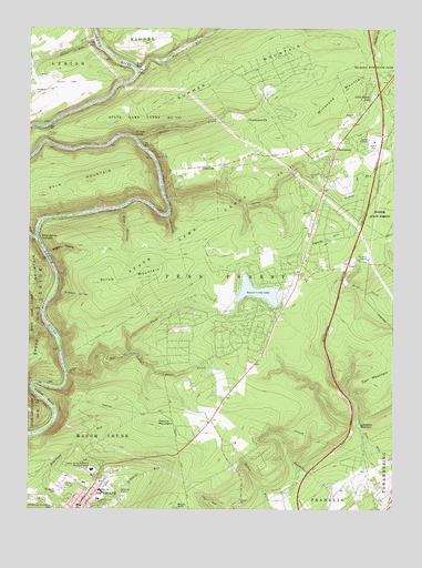
Christmans, PA USGS Topographic Map
Click on map above to begin viewing in our Map Viewer.

This topographic map contains these locations and features:
Feature Name Type Latitude Longitude GNIS ID View Map
Bald MountainSummitN40.9601°W75.7296°1168645View Map
Bear CreekStreamN40.9109°W75.7366°1168857View Map
Bear Creek LakeReservoirN40.9184°W75.6780°1195143View Map
Bear Creek Lake DamDamN40.9184°W75.6780°1195142View Map
Black CreekStreamN40.9459°W75.7455°1169694View Map
Butcher HollowValleyN40.9305°W75.7402°1170783View Map
Carbon CountyCivilN40.9182°W75.7088°1213664View Map
Carbon County FarmLocaleN40.9834°W75.6663°1196621View Map
Carbon County Vocational-Techinical SchoolSchoolN40.8854°W75.7277°1209063View Map
Christman Fire Tower (historical)TowerN40.9165°W75.6813°1196624View Map
ChristmansPopulated PlaceN40.9681°W75.6441°1171827View Map
ChristmansvillePopulated PlaceN40.9765°W75.6749°1203273View Map
Deer Meadows AirstripAirportN40.9971°W75.7384°2442897View Map
Drakes CreekStreamN40.9715°W75.7130°1173452View Map
Drakes CreekPopulated PlaceN40.9718°W75.7113°1203443View Map
Drakes Creek School (historical)SchoolN40.9709°W75.6710°1196620View Map
Evergreen CemeteryCemeteryN40.8797°W75.7385°1174368View Map
Fairview Hose Company District 11BuildingN40.8781°W75.7289°2653247View Map
Hinkles ValleyValleyN40.9455°W75.7474°1177136View Map
Immaculate Conception CemeteryCemeteryN40.8766°W75.7420°1177697View Map
Jim ThorpePopulated PlaceN40.8759°W75.7324°1178082View Map
Jim Thorpe Area Senior High SchoolSchoolN40.8798°W75.7252°1207211View Map
Jim Thorpe Memorial CemeteryCemeteryN40.8847°W75.7254°1192692View Map
Jim Thorpe Police DepartmentBuildingN40.8782°W75.7260°2780218View Map
Kettle HillSummitN40.9451°W75.6482°1178420View Map
L B Morris Elementary SchoolSchoolN40.8809°W75.7296°1207212View Map
Lehigh Gorge State ParkParkN40.9534°W75.7463°1196530View Map
Lehighton Ambulance Penn Forest StationBuildingN40.9770°W75.6357°2722252View Map
Lehighton ReservoirReservoirN40.8968°W75.6363°1179162View Map
Leslie RunStreamN40.9968°W75.7271°1179218View Map
Leslie RunPopulated PlaceN40.9962°W75.7274°1204015View Map
Leslie Run StationLocaleN40.9970°W75.7249°1212357View Map
Little Bear CreekStreamN40.9154°W75.7155°1179461View Map
Little Beaver LakeLakeN40.9824°W75.6319°1179472View Map
M and H Junction StationLocaleN40.9440°W75.7463°1212359View Map
Maple HollowValleyN40.9416°W75.7429°1180349View Map
Millstone MountainSummitN40.9845°W75.6394°1181282View Map
Mud RunPopulated PlaceN40.9898°W75.7124°1204240View Map
Mud RunStreamN40.9881°W75.7121°1182036View Map
Number One DamDamN40.8840°W75.7094°1208735View Map
Number Three DamDamN40.8968°W75.6360°1208731View Map
Number Three DamDamN40.8806°W75.7157°1208737View Map
Number Two DamDamN40.8831°W75.7127°1208736View Map
Oxbow BendBendN40.9070°W75.7471°1183162View Map
Penn Forest HeliportAirportN40.9059°W75.6794°1213793View Map
Penn Forest Township Volunteer Fire Company District 12BuildingN40.9370°W75.6574°2652735View Map
Penn Haven JunctionPopulated PlaceN40.9451°W75.7469°1204376View Map
Penn SpringsSpringN40.9534°W75.7188°1183491View Map
Penn SpringsStreamN40.9531°W75.7182°1209062View Map
Pocono MountainSummitN40.8979°W75.7077°1184151View Map
Rockport StationLocaleN40.9709°W75.7427°1212358View Map
Rockport TunnelTunnelN40.9726°W75.7432°1185320View Map
Saint Joseph's Catholic CemeteryCemeteryN40.8808°W75.7377°1175551View Map
Scrub MountainSummitN40.9340°W75.7274°1187180View Map
State Game Lands Number 141ParkN40.9498°W75.6835°1188448View Map
Stony CreekStreamN40.9545°W75.7021°1188766View Map
Stony Creek (historical)LocaleN40.9545°W75.7021°1196622View Map
Stony Creek School (historical)SchoolN40.9559°W75.6519°1196623View Map
Summer MountainSummitN40.9926°W75.6630°1189023View Map
Tank HollowValleyN40.9510°W75.7023°1189259View Map
Three O'Clock Spring (historical)SpringN40.9393°W75.6369°1198168View Map
Township of Penn ForestCivilN40.9571°W75.6314°1216116View Map
UnionvillePopulated PlaceN40.9640°W75.6880°1204852View Map
Yellow RunStreamN40.9612°W75.6535°1191881View Map

Note: Coordinates in the location and feature list above are referenced to NAD83 datum.


Copyright (C) 2008-2024 Ryan Niemi / Sunset Dynamics ... All Rights Reserved