TopoQuest Logo
Do you find TopoQuest useful?
Help keep TopoQuest running and adding new maps/features by donating!
Bitcoin:  19c7KJd3qBynnjoSw5npx9KScwjBe4ifkT
Litecoin:  LXs6TkuXGGXo1vDsWCkWVdjQX94eUKd6ui
Home View Maps Find Maps Find Places Resources & Links


Papoose Lake, Wisconsin Topographic Map

USGS Map Title: Papoose Lake, WI
USGS Map MRC: 46089B7
DRG (GeoTIFF) Download: o46089b7.tif


Neighboring USGS Topographic Map Quads:


  Chaney Lake, MI  
46089C8
 

  Harris Lake, WI  
46089C7
 

  Stateline Lake, MI  
46089C6
 

  Winchester, WI  
46089B8
 

  Papoose Lake, WI  
46089B7
 

  Presque Isle, WI  
46089B6
 

  Powell, WI  
46089A8
 

  Manitowish Lake, WI  
46089A7
 

  Boulder Junction, WI  
46089A6


Map MRC Location:

N47°
W90°
N47°
W89°
H8 H7 H6 H5 H4 H3 H2 H1
G8 G7 G6 G5 G4 G3 G2 G1
F8 F7 F6 F5 F4 F3 F2 F1
E8 E7 E6 E5 E4 E3 E2 E1
D8 D7 D6 D5 D4 D3 D2 D1
C8 C7 C6 C5 C4 C3 C2 C1
B8 B7 B6 B5 B4 B3 B2 B1
A8 A7 A6 A5 A4 A3 A2 A1
N46°
W90°
N46°
W89°

Papoose Lake, WI USGS 1:24K Topographic Map Preview:
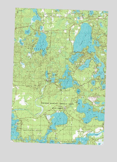
Papoose Lake, WI USGS Topographic Map
Click on map above to begin viewing in our Map Viewer.

This topographic map contains these locations and features:
Feature Name Type Latitude Longitude GNIS ID View Map
Anne LakeLakeN46.1743°W89.7864°1560882View Map
Averill LakeLakeN46.2049°W89.7632°1561032View Map
Big Hurst LakeLakeN46.1796°W89.7521°1578770View Map
Big LakeLakeN46.1547°W89.7697°1578776View Map
Birch LakeLakeN46.2177°W89.8384°1561813View Map
Birch Lake SchoolSchoolN46.2424°W89.8379°1561814View Map
Boot LakeLakeN46.2491°W89.7525°1578838View Map
Camp JornLocaleN46.1416°W89.8696°1833685View Map
Carlin LakeLakeN46.1990°W89.7786°1562716View Map
Clear LakeLakeN46.1472°W89.8117°1563159View Map
Deer LakeLakeN46.2180°W89.8653°1563849View Map
Fawn LakeLakeN46.1342°W89.8259°1564888View Map
Fox IslandIslandN46.1391°W89.8727°1565213View Map
Hiawatha LakeLakeN46.1890°W89.8297°1566344View Map
Jamie LakeLakeN46.2034°W89.7660°2772363View Map
Katinka LakeLakeN46.2054°W89.7926°1567362View Map
Katinka VillagePopulated PlaceN46.2041°W89.8015°1833708View Map
Keith IslandIslandN46.1577°W89.7710°1567374View Map
Little Hurst LakeLakeN46.1829°W89.7555°1568283View Map
Little Papoose LakeLakeN46.1842°W89.8212°1568347View Map
Minonk LakeLakeN46.2482°W89.7714°1579887View Map
North Lakeland Elementary SchoolSchoolN46.1584°W89.8033°1833711View Map
Noseeum LakeLakeN46.1890°W89.8206°1570567View Map
Papoose LakeLakeN46.1848°W89.8027°1571018View Map
Presque Isle CemeteryCemeteryN46.2436°W89.7626°1576862View Map
Presque Isle LakeLakeN46.2241°W89.7832°1571920View Map
Presque Isle School (historical)SchoolN46.2447°W89.7882°1571922View Map
Pukall LakeLakeN46.1643°W89.7603°2761347View Map
Rainbow LakeLakeN46.2431°W89.8470°1580221View Map
Red LakeLakeN46.1829°W89.7666°1572144View Map
Rice CreekStreamN46.1288°W89.7860°1580249View Map
Rosalind LakeLakeN46.1819°W89.7902°1572594View Map
Spread LakeLakeN46.2364°W89.7587°1574585View Map
Stone LakeLakeN46.1260°W89.8325°1574930View Map
Tamarack LakeLakeN46.2282°W89.8575°1575243View Map
Town of WinchesterCivilN46.2221°W89.8688°1584451View Map
Van Vliet LakeLakeN46.2170°W89.7757°1576042View Map
Winchester Memorial CemeteryCemeteryN46.2452°W89.8358°1833733View Map

Note: Coordinates in the location and feature list above are referenced to NAD83 datum.


Copyright (C) 2008-2025 Ryan Niemi / Sunset Dynamics ... All Rights Reserved