TopoQuest Logo
Do you find TopoQuest useful?
Help keep TopoQuest running and adding new maps/features by donating!
Bitcoin:  19c7KJd3qBynnjoSw5npx9KScwjBe4ifkT
Litecoin:  LXs6TkuXGGXo1vDsWCkWVdjQX94eUKd6ui
Home View Maps Find Maps Find Places Resources & Links


Paradox Lake, New York Topographic Map

USGS Map Title: Paradox Lake, NY
USGS Map MRC: 43073H6
DRG (GeoTIFF) Download: o43073h6.tif


Neighboring USGS Topographic Map Quads:


  Paradox Lake, NY  
43073H6
 

  Eagle Lake, NY  
43073H5


  Pharaoh Mountain, NY  
43073G6
 

  Graphite, NY  
43073G5


Map MRC Location:

N44°
W74°
N44°
W73°
H8 H7 H6 H5 H4 H3 H2 H1
G8 G7 G6 G5 G4 G3 G2 G1
F8 F7 F6 F5 F4 F3 F2 F1
E8 E7 E6 E5 E4 E3 E2 E1
D8 D7 D6 D5 D4 D3 D2 D1
C8 C7 C6 C5 C4 C3 C2 C1
B8 B7 B6 B5 B4 B3 B2 B1
A8 A7 A6 A5 A4 A3 A2 A1
N43°
W74°
N43°
W73°

Paradox Lake, NY USGS 1:24K Topographic Map Preview:
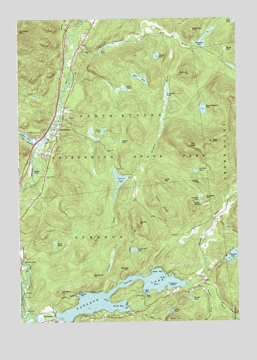
Paradox Lake, NY USGS Topographic Map
Click on map above to begin viewing in our Map Viewer.

This topographic map contains these locations and features:
Feature Name Type Latitude Longitude GNIS ID View Map
Bald PateSummitN43.9495°W73.6387°942877View Map
Bass LakeLakeN43.9756°W73.6794°943144View Map
Berrymill HillSummitN43.9776°W73.6512°943755View Map
Berrymill PondLakeN43.9647°W73.6640°943757View Map
Birch IslandIslandN43.8906°W73.6737°943998View Map
Black BrookStreamN43.9867°W73.7165°944087View Map
Bloody PondLakeN43.9874°W73.6310°944280View Map
Briar PointCapeN43.8839°W73.6996°944709View Map
Bumbo PondLakeN43.8844°W73.6518°945173View Map
Burnt Mill BrookStreamN43.9153°W73.6371°945257View Map
Carey MarshLakeN43.9073°W73.7287°945828View Map
Challis PondLakeN43.9847°W73.6701°946343View Map
Cotters PondLakeN43.8788°W73.6646°947523View Map
Crawford IslandIslandN43.8901°W73.6646°947721View Map
Dark BayBayN43.8876°W73.6785°948032View Map
Flemings PondLakeN43.9019°W73.6279°950277View Map
Gero PondLakeN43.9878°W73.7009°951040View Map
Gooseberry HillSummitN43.8876°W73.7274°951378View Map
Grass IslandIslandN43.8931°W73.6696°951540View Map
Grosvenor BayBayN43.8862°W73.7162°951848View Map
Hammond PondLakeN43.9881°W73.6423°952129View Map
Hatch PondLakeN43.9710°W73.6891°952365View Map
Indian RidgeRidgeN43.9237°W73.6679°953692View Map
Johnson PondLakeN43.9335°W73.6915°954131View Map
Johnson Pond BrookStreamN43.8912°W73.6929°954133View Map
Legoys BayBayN43.8953°W73.6707°955181View Map
Linsey FallsFallsN43.9367°W73.7412°955423View Map
Little CanadaSummitN43.9234°W73.6496°955479View Map
Long SueSummitN43.9328°W73.6671°955933View Map
Moose Mountain PondLakeN43.9627°W73.6441°957628View Map
Narrows MountainSummitN43.8967°W73.6876°958271View Map
North HudsonPopulated PlaceN43.9526°W73.7285°958825View Map
North Hudson Town LandfillLocaleN43.9597°W73.7219°2678401View Map
North Hudson Volunteer Fire DepartmentBuildingN43.9603°W73.7233°2718707View Map
Owl PateSummitN43.9481°W73.6512°959679View Map
Owl Pate PondSummitN43.9367°W73.6485°959680View Map
Palmer PondLakeN43.9521°W73.7459°959796View Map
ParadoxPopulated PlaceN43.8914°W73.6457°959848View Map
Paradox CreekStreamN43.8906°W73.6501°959850View Map
Paradox LakeLakeN43.8864°W73.6993°970453View Map
Paragon BrookStreamN43.8906°W73.6493°959851View Map
Peaked HillSummitN43.9156°W73.6812°960038View Map
Peaked Hill PondLakeN43.9048°W73.6844°960039View Map
Peaked Hill TrailTrailN43.9067°W73.6860°960040View Map
Pidgeon HillSummitN43.9326°W73.6457°960350View Map
Pine Ridge CemeteryCemeteryN43.9874°W73.7107°960547View Map
Proctor PondLakeN43.9538°W73.7014°961152View Map
Schofield HillSummitN43.9256°W73.6432°964596View Map
Schofield PondLakeN43.9257°W73.6460°964597View Map
Schroon FallsPopulated PlaceN43.8992°W73.7487°973047View Map
Schroon River CemeteryCemeteryN43.9351°W73.7343°964623View Map
SeverancePopulated PlaceN43.8759°W73.7304°964874View Map
Smith BayBayN43.8809°W73.6937°965454View Map
Stevens PondLakeN43.9493°W73.6912°966386View Map
Sweet Fern HillSummitN43.9953°W73.6493°966914View Map
The BranchStreamN43.9484°W73.7379°967207View Map
Walker BrookStreamN43.9931°W73.7207°968678View Map
Woodchuck HillSummitN43.8942°W73.7076°971619View Map

Note: Coordinates in the location and feature list above are referenced to NAD83 datum.


Copyright (C) 2008-2025 Ryan Niemi / Sunset Dynamics ... All Rights Reserved