TopoQuest Logo
Do you find TopoQuest useful?
Help keep TopoQuest running and adding new maps/features by donating!
Bitcoin:  19c7KJd3qBynnjoSw5npx9KScwjBe4ifkT
Litecoin:  LXs6TkuXGGXo1vDsWCkWVdjQX94eUKd6ui
Home View Maps Find Maps Find Places Resources & Links


Graphite, New York Topographic Map

USGS Map Title: Graphite, NY
USGS Map MRC: 43073G5
DRG (GeoTIFF) Download: o43073g5.tif


Neighboring USGS Topographic Map Quads:


  Paradox Lake, NY  
43073H6
 

  Eagle Lake, NY  
43073H5
 

  Crown Point, NY  
43073H4
 

  Pharaoh Mountain, NY  
43073G6
 

  Graphite, NY  
43073G5
 

  Ticonderoga, NY  
43073G4
 

  Brant Lake, NY  
43073F6
 

  Silver Bay, NY  
43073F5
 

  Putnam, NY  
43073F4


Map MRC Location:

N44°
W74°
N44°
W73°
H8 H7 H6 H5 H4 H3 H2 H1
G8 G7 G6 G5 G4 G3 G2 G1
F8 F7 F6 F5 F4 F3 F2 F1
E8 E7 E6 E5 E4 E3 E2 E1
D8 D7 D6 D5 D4 D3 D2 D1
C8 C7 C6 C5 C4 C3 C2 C1
B8 B7 B6 B5 B4 B3 B2 B1
A8 A7 A6 A5 A4 A3 A2 A1
N43°
W74°
N43°
W73°

Graphite, NY USGS 1:24K Topographic Map Preview:
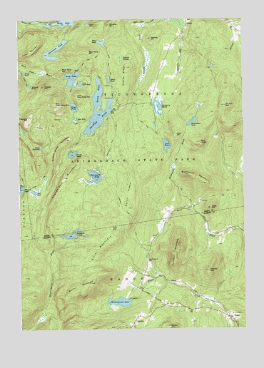
Graphite, NY USGS Topographic Map
Click on map above to begin viewing in our Map Viewer.

This topographic map contains these locations and features:
Feature Name Type Latitude Longitude GNIS ID View Map
Abes HillSummitN43.8284°W73.5376°942125View Map
Bald LedgeBenchN43.8253°W73.5237°942856View Map
Barton MountainSummitN43.7687°W73.5854°943120View Map
Bear PondLakeN43.8659°W73.5777°943295View Map
Bear Pond MountainSummitN43.8617°W73.5871°943301View Map
Bear Pond TrailTrailN43.8614°W73.5751°943302View Map
Berrymile Pond TrailTrailN43.8189°W73.5762°943754View Map
Berrymill PondLakeN43.8119°W73.5826°943756View Map
Big Clear Pond MountainSummitN43.8417°W73.6046°943865View Map
Blanchard MountainSummitN43.8123°W73.5307°944226View Map
Burnt RidgeRidgeN43.8039°W73.5643°945269View Map
Chilson Volunteer Fire DepartmentBuildingN43.8737°W73.5306°2734805View Map
Clear PondLakeN43.8397°W73.5937°946826View Map
Clear Pond TrailTrailN43.8528°W73.5818°946834View Map
Cranberry MarshLakeN43.8400°W73.5467°947663View Map
Devils WashdishLakeN43.8235°W73.6125°948374View Map
Ellis MountainSummitN43.7831°W73.5790°949528View Map
Fernette MountainSummitN43.8728°W73.5746°949995View Map
Gooseneck PondLakeN43.8625°W73.6041°951383View Map
GraphitePopulated PlaceN43.7512°W73.5629°951532View Map
Grizzle OceanLakeN43.8209°W73.5953°951837View Map
Grizzle Ocean MountainSummitN43.8264°W73.5985°951838View Map
Hague Volunteer Fire Department and Emergency Squad Station 1BuildingN43.7555°W73.5099°2735480View Map
Haymeadow BrookStreamN43.7998°W73.5285°952450View Map
Haymeadow PondLakeN43.8336°W73.5281°952451View Map
Heart PondLakeN43.8511°W73.5741°952488View Map
Honey PondLakeN43.8536°W73.6215°953146View Map
Lilypad PondLakeN43.8480°W73.6179°955329View Map
Little Clear Pond MountainSummitN43.8445°W73.5926°955495View Map
Little Rock PondLakeN43.8490°W73.5902°955661View Map
Lost PondLakeN43.8242°W73.5426°956023View Map
Lost Pond TrailTrailN43.8309°W73.5518°956034View Map
May Memorial CemeteryCemeteryN43.7776°W73.5540°956700View Map
Mud PondLakeN43.8346°W73.5928°958080View Map
Nances HillSummitN43.8673°W73.5512°958242View Map
North PondLakeN43.8453°W73.5807°958890View Map
Old Fort MountainSummitN43.8401°W73.5101°959284View Map
Otter PondLakeN43.8730°W73.5856°959576View Map
Peaked HillSummitN43.8481°W73.6104°960037View Map
Peshette SwampSwampN43.8592°W73.5679°960225View Map
Pine HillSummitN43.7909°W73.5740°960474View Map
Potter MountainSummitN43.8614°W73.6179°961044View Map
Putnam PondLakeN43.8348°W73.5803°962013View Map
Rock PondLakeN43.8487°W73.5944°962721View Map
Rock Pond MountainSummitN43.8548°W73.6007°962727View Map
Rock Pond TrailTrailN43.8467°W73.5954°962729View Map
Sharps RidgeRidgeN43.8526°W73.5654°964955View Map
Short Swing TrailTrailN43.8501°W73.6201°965174View Map
Springhill PondsLakeN43.7879°W73.5967°970641View Map
Thomas MountainSummitN43.7734°W73.5196°967401View Map
Thunderbolt MountainSummitN43.8112°W73.5998°967484View Map
Treadway MountainSummitN43.8351°W73.6196°967772View Map
Treadway Mountain TrailTrailN43.8348°W73.5996°967773View Map
Trumbull MountainSummitN43.7845°W73.5368°967912View Map
Wells HillSummitN43.7987°W73.5185°969048View Map
Wintergreen LakeLakeN43.7610°W73.5694°971515View Map
Wolf PondLakeN43.8056°W73.6170°971564View Map

Note: Coordinates in the location and feature list above are referenced to NAD83 datum.


Copyright (C) 2008-2024 Ryan Niemi / Sunset Dynamics ... All Rights Reserved