TopoQuest Logo
Do you find TopoQuest useful?
Help keep TopoQuest running and adding new maps/features by donating!
Bitcoin:  19c7KJd3qBynnjoSw5npx9KScwjBe4ifkT
Litecoin:  LXs6TkuXGGXo1vDsWCkWVdjQX94eUKd6ui
Home View Maps Find Maps Find Places Resources & Links


Paris North, Illinois Topographic Map

USGS Map Title: Paris North, IL
USGS Map MRC: 39087F6
DRG (GeoTIFF) Download: o39087f6.tif


Neighboring USGS Topographic Map Quads:


  Hume, IL  
39087G7
 

  Chrisman, IL  
39087G6
 

  Scottland, IL  
39087G5
 

  Redmon, IL  
39087F7
 

  Paris North, IL  
39087F6
 

  Saint Bernice, IN  
39087F5
 

  Grandview, IL  
39087E7
 

  Paris South, IL  
39087E6
 

  Sandford, IN  
39087E5


Map MRC Location:

N40°
W88°
N40°
W87°
H8 H7 H6 H5 H4 H3 H2 H1
G8 G7 G6 G5 G4 G3 G2 G1
F8 F7 F6 F5 F4 F3 F2 F1
E8 E7 E6 E5 E4 E3 E2 E1
D8 D7 D6 D5 D4 D3 D2 D1
C8 C7 C6 C5 C4 C3 C2 C1
B8 B7 B6 B5 B4 B3 B2 B1
A8 A7 A6 A5 A4 A3 A2 A1
N39°
W88°
N39°
W87°

Paris North, IL USGS 1:24K Topographic Map Preview:
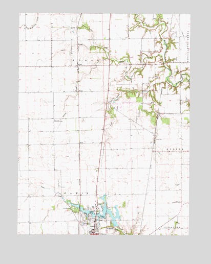
Paris North, IL USGS Topographic Map
Click on map above to begin viewing in our Map Viewer.

This topographic map contains these locations and features:
Feature Name Type Latitude Longitude GNIS ID View Map
Baldwinsville Post Office (historical)Post OfficeN39.6720°W87.6309°1808092View Map
Baldwinville School (historical)SchoolN39.6725°W87.6389°1736473View Map
Banner School (historical)SchoolN39.7048°W87.6361°1736474View Map
Camp BlackhawkLocaleN39.6398°W87.7111°405435View Map
Conkey CemeteryCemeteryN39.6794°W87.6502°406469View Map
Edgar CountyCivilN39.6785°W87.7456°424224View Map
Edgar County AirportAirportN39.7002°W87.6696°427648View Map
Franklin CemeteryCemeteryN39.7306°W87.6845°408660View Map
Franklin Church (historical)ChurchN39.7300°W87.6834°1736493View Map
HarrisPopulated PlaceN39.6764°W87.7053°422784View Map
HoracePopulated PlaceN39.7203°W87.7067°410534View Map
Indian CreekStreamN39.7320°W87.6953°410836View Map
Kimble School (historical)SchoolN39.6473°W87.6822°1736506View Map
Lanes Branch School (historical)SchoolN39.6292°W87.6328°1736508View Map
Larkin School (historical)SchoolN39.7211°W87.6789°1736509View Map
Mark School (historical)SchoolN39.7489°W87.7447°1736516View Map
Midway Landing Field (historical)AirportN39.7153°W87.6847°1736521View Map
North Arm Church (historical)ChurchN39.6439°W87.6314°1736527View Map
North Arm Community CenterBuildingN39.6436°W87.6311°414558View Map
Paris Airport (historical)AirportN39.6542°W87.7175°1736529View Map
Paris Memorial GardensCemeteryN39.6320°W87.6959°415378View Map
Pine Grove Community CenterBuildingN39.6898°W87.7234°415699View Map
Pine Grove School (historical)SchoolN39.6900°W87.7236°1736533View Map
Plum Grove School (historical)SchoolN39.6303°W87.7220°1736534View Map
Saint Marys CemeteryCemeteryN39.6336°W87.6956°417558View Map
Scott CemeteryCemeteryN39.7171°W87.6330°418140View Map
Scott School (historical)SchoolN39.7306°W87.6331°1736545View Map
Sixteen CemeteryCemeteryN39.6536°W87.6350°418563View Map
Snake CreekStreamN39.7128°W87.6417°418666View Map
South Fork Brouilletts CreekStreamN39.7256°W87.6439°418753View Map
Sugar Creek School (historical)SchoolN39.6461°W87.7231°1736554View Map
Third LakeReservoirN39.6250°W87.6750°1691899View Map
Third Lake DamDamN39.6250°W87.6750°1691898View Map
Township of EdgarCivilN39.7387°W87.7037°428941View Map
Township of ParisCivilN39.6322°W87.7089°429528View Map
Twin LakesReservoirN39.6371°W87.6833°419985View Map
WetzelPopulated PlaceN39.7061°W87.7061°423304View Map
Willow CreekStreamN39.7248°W87.6853°421236View Map
Wolf MoundSummitN39.6892°W87.7031°1808129View Map

Note: Coordinates in the location and feature list above are referenced to NAD83 datum.


Copyright (C) 2008-2025 Ryan Niemi / Sunset Dynamics ... All Rights Reserved