TopoQuest Logo
Do you find TopoQuest useful?
Help keep TopoQuest running and adding new maps/features by donating!
Bitcoin:  19c7KJd3qBynnjoSw5npx9KScwjBe4ifkT
Litecoin:  LXs6TkuXGGXo1vDsWCkWVdjQX94eUKd6ui
Home View Maps Find Maps Find Places Resources & Links


Paris South, Illinois Topographic Map

USGS Map Title: Paris South, IL
USGS Map MRC: 39087E6
DRG (GeoTIFF) Download: o39087e6.tif


Neighboring USGS Topographic Map Quads:


  Redmon, IL  
39087F7
 

  Paris North, IL  
39087F6
 

  Saint Bernice, IN  
39087F5
 

  Grandview, IL  
39087E7
 

  Paris South, IL  
39087E6
 

  Sandford, IN  
39087E5
 

  Clarksville, IL  
39087D7
 

  Marshall, IL  
39087D6
 

  Dennison, IL  
39087D5


Map MRC Location:

N40°
W88°
N40°
W87°
H8 H7 H6 H5 H4 H3 H2 H1
G8 G7 G6 G5 G4 G3 G2 G1
F8 F7 F6 F5 F4 F3 F2 F1
E8 E7 E6 E5 E4 E3 E2 E1
D8 D7 D6 D5 D4 D3 D2 D1
C8 C7 C6 C5 C4 C3 C2 C1
B8 B7 B6 B5 B4 B3 B2 B1
A8 A7 A6 A5 A4 A3 A2 A1
N39°
W88°
N39°
W87°

Paris South, IL USGS 1:24K Topographic Map Preview:
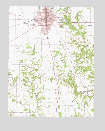
Paris South, IL USGS Topographic Map
Click on map above to begin viewing in our Map Viewer.

This topographic map contains these locations and features:
Feature Name Type Latitude Longitude GNIS ID View Map
Camp Chapel School (historical)SchoolN39.5939°W87.6295°1736479View Map
Carolyn Wenz Elementary SchoolSchoolN39.6103°W87.7020°420756View Map
Cassady CemeteryCemeteryN39.5658°W87.7150°405689View Map
City of ParisCivilN39.6148°W87.6905°2396141View Map
Crestwood Junior High SchoolSchoolN39.6070°W87.6739°406781View Map
Eads LakeReservoirN39.6089°W87.6693°1691895View Map
Eads Lake DamDamN39.6100°W87.6667°1691894View Map
East ForkStreamN39.5048°W87.7122°1736487View Map
Edgar CemeteryCemeteryN39.6236°W87.6867°407772View Map
Edgar County CourthouseBuildingN39.6117°W87.6956°1736488View Map
Edgar County Sheriff's OfficeBuildingN39.6125°W87.6956°2758843View Map
Edgar County Special Service Area AmbulanceBuildingN39.5953°W87.6948°2673808View Map
Elks Country ClubLocaleN39.6153°W87.6661°424871View Map
Elledge Holley CemeteryCemeteryN39.5231°W87.7389°407886View Map
First Assembly of God ChurchChurchN39.6223°W87.6978°1808100View Map
First Baptist ChurchChurchN39.6100°W87.6964°1808101View Map
First Christian ChurchChurchN39.6100°W87.6953°1808102View Map
First United Methodist ChurchChurchN39.6109°W87.7000°1808103View Map
Fort Sumter School (historical)SchoolN39.5478°W87.7014°1736492View Map
Grace Lutheran ChurchChurchN39.6045°W87.6947°1808105View Map
Gumm LakeReservoirN39.5336°W87.7423°1691905View Map
Gumm Lake DamDamN39.5334°W87.7417°1691904View Map
Jefferson School (historical)SchoolN39.5056°W87.6667°1736501View Map
Lawrence See LakeReservoirN39.5348°W87.7409°1692593View Map
Lawrence See Lake DamDamN39.5350°W87.7417°1692592View Map
Lycan CemeteryCemeteryN39.5550°W87.7175°412752View Map
Mayo Middle SchoolSchoolN39.6117°W87.6897°413164View Map
McCord School (historical)SchoolN39.5639°W87.6578°1736518View Map
Memorial Elementary SchoolSchoolN39.6050°W87.6881°1736520View Map
NevinsPopulated PlaceN39.5339°W87.6386°414377View Map
New Hope CemeteryCemeteryN39.5478°W87.7453°1808115View Map
New Hope ChurchChurchN39.5475°W87.7453°414428View Map
New Hope School (historical)SchoolN39.5592°W87.7386°1736525View Map
North Union School (historical)SchoolN39.6095°W87.7406°1736528View Map
Ogden CemeteryCemeteryN39.5439°W87.6953°414961View Map
ParisPopulated PlaceN39.6111°W87.6961°415377View Map
Paris Community HospitalHospitalN39.6068°W87.6772°1808119View Map
Paris Community Hospital HeliportAirportN39.6078°W87.6764°427646View Map
Paris Fire DepartmentBuildingN39.6104°W87.6978°2681959View Map
Paris High SchoolSchoolN39.6084°W87.6953°1736530View Map
Paris Police DepartmentBuildingN39.6104°W87.6976°2759111View Map
Paris Post OfficePost OfficeN39.6126°W87.6935°1736531View Map
Redmon CemeteryCemeteryN39.5819°W87.6995°416479View Map
Redmon Elementary SchoolSchoolN39.6017°W87.6953°416480View Map
Rhodes School (historical)SchoolN39.5395°W87.6700°1736538View Map
Saint Marys Catholic ChurchChurchN39.6181°W87.6947°1808124View Map
Saint Marys SchoolSchoolN39.6178°W87.6934°417608View Map
Simms CemeteryCemeteryN39.5287°W87.6439°418525View Map
South Union School (historical)SchoolN39.5309°W87.7484°1736550View Map
State Highway Paris HeliportAirportN39.6034°W87.7122°427647View Map
Stewart Airport (historical)AirportN39.5848°W87.6984°1736552View Map
Sulphur Springs School (historical)SchoolN39.6006°W87.6689°1736556View Map
Sunrise ParkParkN39.6189°W87.6856°419405View Map
Sunset ParkParkN39.6139°W87.7081°419419View Map
Swango CemeteryCemeteryN39.5376°W87.7158°419464View Map
Sylvain ParkParkN39.6028°W87.6942°419504View Map
Symmes TownhallBuildingN39.5478°W87.7014°1736558View Map
Tanner SchoolSchoolN39.6139°W87.6997°419540View Map
Township of SymmesCivilN39.5320°W87.7060°429821View Map
Trinity United Methodist ChurchChurchN39.6198°W87.6961°1808127View Map
Turner School (historical)SchoolN39.5814°W87.7120°1736559View Map
Vance Elementary SchoolSchoolN39.6223°W87.6950°420224View Map
WACF-FM (Paris)TowerN39.6059°W87.7264°428266View Map
Walls CemeteryCemeteryN39.5092°W87.7059°420435View Map
Walls School (historical)SchoolN39.5089°W87.7059°1736561View Map
Wilkins CemeteryCemeteryN39.5765°W87.6261°421177View Map
WPRS-AM (Paris)TowerN39.6059°W87.7264°428059View Map

Note: Coordinates in the location and feature list above are referenced to NAD83 datum.


Copyright (C) 2008-2024 Ryan Niemi / Sunset Dynamics ... All Rights Reserved