TopoQuest Logo
Do you find TopoQuest useful?
Help keep TopoQuest running and adding new maps/features by donating!
Bitcoin:  19c7KJd3qBynnjoSw5npx9KScwjBe4ifkT
Litecoin:  LXs6TkuXGGXo1vDsWCkWVdjQX94eUKd6ui
Home View Maps Find Maps Find Places Resources & Links


Clarksville, Illinois Topographic Map

USGS Map Title: Clarksville, IL
USGS Map MRC: 39087D7
DRG (GeoTIFF) Download: o39087d7.tif


Neighboring USGS Topographic Map Quads:


  Kansas, IL  
39087E8
 

  Grandview, IL  
39087E7
 

  Paris South, IL  
39087E6
 

  Westfield East, IL  
39087D8
 

  Clarksville, IL  
39087D7
 

  Marshall, IL  
39087D6
 

  Casey, IL  
39087C8
 

  Clark Center, IL  
39087C7
 

  Snyder, IL  
39087C6


Map MRC Location:

N40°
W88°
N40°
W87°
H8 H7 H6 H5 H4 H3 H2 H1
G8 G7 G6 G5 G4 G3 G2 G1
F8 F7 F6 F5 F4 F3 F2 F1
E8 E7 E6 E5 E4 E3 E2 E1
D8 D7 D6 D5 D4 D3 D2 D1
C8 C7 C6 C5 C4 C3 C2 C1
B8 B7 B6 B5 B4 B3 B2 B1
A8 A7 A6 A5 A4 A3 A2 A1
N39°
W88°
N39°
W87°

Clarksville, IL USGS 1:24K Topographic Map Preview:
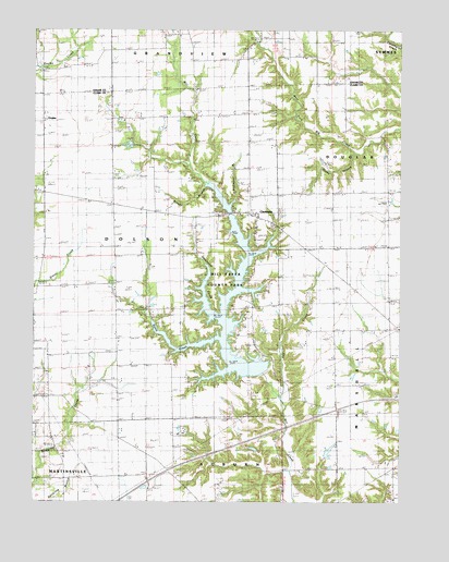
Clarksville, IL USGS Topographic Map
Click on map above to begin viewing in our Map Viewer.

This topographic map contains these locations and features:
Feature Name Type Latitude Longitude GNIS ID View Map
Bartmess School (historical)SchoolN39.4295°W87.8739°403944View Map
Bluegrass CemeteryCemeteryN39.4092°W87.8703°1922872View Map
Bluegrass School (historical)SchoolN39.4059°W87.8695°404614View Map
Boyer CemeteryCemeteryN39.4947°W87.8025°1808094View Map
Brossman School (historical)SchoolN39.3961°W87.8211°404927View Map
Brushy BranchStreamN39.4592°W87.8145°405046View Map
ClarksvillePopulated PlaceN39.4517°W87.7978°406177View Map
Clarksville Baptist CemeteryCemeteryN39.4478°W87.7939°1922892View Map
Cupps CemeteryCemeteryN39.4736°W87.8434°1922904View Map
Davis CemeteryCemeteryN39.4153°W87.7984°406971View Map
DoylesPopulated PlaceN39.4759°W87.8720°1736441View Map
East Liberty SchoolSchoolN39.4656°W87.8325°407667View Map
Ennis CreekStreamN39.4181°W87.8100°408033View Map
Fox CreekStreamN39.4023°W87.7900°408617View Map
Germany School (historical)SchoolN39.4781°W87.8014°408977View Map
Green Moss CemeteryCemeteryN39.4370°W87.8353°1922924View Map
Green Moss ChurchChurchN39.4384°W87.8339°409388View Map
Green Moss School (historical)SchoolN39.4256°W87.8220°409389View Map
Kelly School (historical)SchoolN39.3806°W87.8731°411374View Map
Martin Tarble LakeReservoirN39.4695°W87.8429°1691825View Map
Martin Tarble Lake DamDamN39.4717°W87.8400°1691824View Map
Mill Creek County ParkParkN39.4375°W87.8084°1736454View Map
Mill Creek Impoundment Number 2 ReservoirReservoirN39.3891°W87.7998°1692037View Map
Mill Creek Structure Number 2 DamDamN39.3884°W87.7984°1692036View Map
Mill Creek Watershed Structure Number 1 DamDamN39.4067°W87.7950°1692644View Map
Mitchell CemeteryCemeteryN39.4023°W87.7542°413685View Map
Perry RLA AirportAirportN39.4789°W87.8460°2770523View Map
Pikes Peak School (historical)SchoolN39.4584°W87.7584°415671View Map
Pleasant Grove School (historical)SchoolN39.4214°W87.7728°415803View Map
Robert Lashbrook PondReservoirN39.3885°W87.7741°1692039View Map
Robert Lashbrook Pond DamDamN39.3884°W87.7750°1692038View Map
Rocky BranchStreamN39.4678°W87.7653°416865View Map
Rocky Branch Nature PreserveParkN39.4659°W87.7659°1993293View Map
Salem Church (historical)ChurchN39.4100°W87.8264°417875View Map
Sevenmile CreekStreamN39.4242°W87.8106°418230View Map
Shiloh CemeteryCemeteryN39.4514°W87.8714°1922977View Map
Shiloh Church (historical)ChurchN39.4509°W87.8714°418419View Map
Snakeden BranchStreamN39.4542°W87.8081°418670View Map
Spiketown School (historical)SchoolN39.3828°W87.7523°418902View Map
Taylor CemeteryCemeteryN39.4737°W87.8434°2745654View Map
Township of DolsonCivilN39.4400°W87.8470°428901View Map

Note: Coordinates in the location and feature list above are referenced to NAD83 datum.


Copyright (C) 2008-2024 Ryan Niemi / Sunset Dynamics ... All Rights Reserved