TopoQuest Logo
Do you find TopoQuest useful?
Help keep TopoQuest running and adding new maps/features by donating!
Bitcoin:  19c7KJd3qBynnjoSw5npx9KScwjBe4ifkT
Litecoin:  LXs6TkuXGGXo1vDsWCkWVdjQX94eUKd6ui
Home View Maps Find Maps Find Places Resources & Links


Paris West, Missouri Topographic Map

USGS Map Title: Paris West, MO
USGS Map MRC: 39092D1
DRG (GeoTIFF) Download: o39092d1.tif


Neighboring USGS Topographic Map Quads:


  Woodlawn, MO  
39092E2
 

  Granville, MO  
39092E1
 

  Goss, MO  
39091E8
 

  Madison, MO  
39092D2
 

  Paris West, MO  
39092D1
 

  Paris East, MO  
39091D8
 

  Tulip, MO  
39092C2
 

  Rowena, MO  
39092C1
 

  Molino, MO  
39091C8


Map MRC Location:

N40°
W93°
N40°
W92°
H8 H7 H6 H5 H4 H3 H2 H1
G8 G7 G6 G5 G4 G3 G2 G1
F8 F7 F6 F5 F4 F3 F2 F1
E8 E7 E6 E5 E4 E3 E2 E1
D8 D7 D6 D5 D4 D3 D2 D1
C8 C7 C6 C5 C4 C3 C2 C1
B8 B7 B6 B5 B4 B3 B2 B1
A8 A7 A6 A5 A4 A3 A2 A1
N39°
W93°
N39°
W92°

Paris West, MO USGS 1:24K Topographic Map Preview:
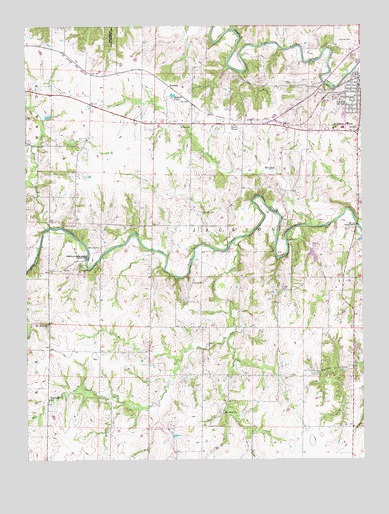
Paris West, MO USGS Topographic Map
Click on map above to begin viewing in our Map Viewer.

This topographic map contains these locations and features:
Feature Name Type Latitude Longitude GNIS ID View Map
Bakers PondLakeN39.4801°W92.0703°713580View Map
Bee CreekStreamN39.4381°W92.0477°713865View Map
Boomer CemeteryCemeteryN39.4959°W92.0079°714529View Map
Brazeale Farm Airport (historical)AirportN39.4834°W92.0668°758850View Map
Briar CreekStreamN39.4423°W92.1163°714680View Map
Cecil (historical)LocaleN39.3956°W92.0793°744012View Map
Cedar Bluff School (historical)SchoolN39.4353°W92.0496°743982View Map
Central Stone County Lake DamDamN39.4350°W92.0185°762095View Map
City of ParisCivilN39.4774°W92.0039°2396142View Map
Cross Hollow School (historical)SchoolN39.4799°W92.1003°743980View Map
Curtright CemeteryCemeteryN39.4466°W92.0601°716610View Map
Deaver CemeteryCemeteryN39.4261°W92.0633°716776View Map
Foreman School (historical)SchoolN39.3967°W92.0796°743983View Map
FowkesPopulated PlaceN39.4831°W92.0716°740858View Map
Lake Village AirportAirportN39.4574°W92.0091°758852View Map
McKinney CemeteryCemeteryN39.4362°W92.0978°722146View Map
Monroe CountyCivilN39.4955°W92.0007°758523View Map
Mount Airy ChurchChurchN39.4139°W92.1171°729346View Map
Mount Zion ChurchChurchN39.3884°W92.0524°729351View Map
ParisPopulated PlaceN39.4809°W92.0013°724007View Map
Paris Elementary SchoolSchoolN39.4723°W92.0067°2650062View Map
Paris Fire DepartmentBuildingN39.4818°W92.0011°2621729View Map
Paris High SchoolSchoolN39.4703°W92.0073°2650063View Map
Paris Post OfficePost OfficeN39.4828°W92.0017°2783070View Map
Paris Rural Fire Protection DistrictBuildingN39.4817°W92.0010°2620398View Map
Pooles BranchStreamN39.4420°W92.0185°729371View Map
Saint Francis Cabrini ChurchChurchN39.4703°W92.0104°725746View Map
Sanford School (historical)SchoolN39.3923°W92.1171°726048View Map
Shiloh CemeteryCemeteryN39.4709°W92.0636°726363View Map
Snell School (historical)SchoolN39.3925°W92.0505°743984View Map
Township of JacksonCivilN39.4547°W92.0113°767039View Map
Union BridgeBridgeN39.4328°W92.1024°755438View Map
Union CemeteryCemeteryN39.4312°W92.1055°727965View Map
Union School (historical)SchoolN39.4281°W92.1060°743981View Map
Welch (historical)LocaleN39.4142°W92.1168°744057View Map
Youngs CemeteryCemeteryN39.4240°W92.0307°729213View Map

Note: Coordinates in the location and feature list above are referenced to NAD83 datum.


Copyright (C) 2008-2025 Ryan Niemi / Sunset Dynamics ... All Rights Reserved