TopoQuest Logo
Do you find TopoQuest useful?
Help keep TopoQuest running and adding new maps/features by donating!
Bitcoin:  19c7KJd3qBynnjoSw5npx9KScwjBe4ifkT
Litecoin:  LXs6TkuXGGXo1vDsWCkWVdjQX94eUKd6ui
Home View Maps Find Maps Find Places Resources & Links


Paris East, Missouri Topographic Map

USGS Map Title: Paris East, MO
USGS Map MRC: 39091D8
DRG (GeoTIFF) Download: o39091d8.tif


Neighboring USGS Topographic Map Quads:


  Granville, MO  
39092E1
 

  Goss, MO  
39091E8
 

  Stoutsville, MO  
39091E7
 

  Paris West, MO  
39092D1
 

  Paris East, MO  
39091D8
 

  Florida, MO  
39091D7
 

  Rowena, MO  
39092C1
 

  Molino, MO  
39091C8
 

  Santa Fe, MO  
39091C7


Map MRC Location:

N40°
W92°
N40°
W91°
H8 H7 H6 H5 H4 H3 H2 H1
G8 G7 G6 G5 G4 G3 G2 G1
F8 F7 F6 F5 F4 F3 F2 F1
E8 E7 E6 E5 E4 E3 E2 E1
D8 D7 D6 D5 D4 D3 D2 D1
C8 C7 C6 C5 C4 C3 C2 C1
B8 B7 B6 B5 B4 B3 B2 B1
A8 A7 A6 A5 A4 A3 A2 A1
N39°
W92°
N39°
W91°

Paris East, MO USGS 1:24K Topographic Map Preview:
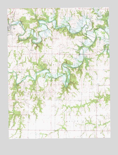
Paris East, MO USGS Topographic Map
Click on map above to begin viewing in our Map Viewer.

This topographic map contains these locations and features:
Feature Name Type Latitude Longitude GNIS ID View Map
Cedar Grove ChurchChurchN39.4387°W91.9849°729290View Map
Coon CreekStreamN39.4307°W91.9673°716246View Map
Elk Fork Salt RiverStreamN39.4667°W91.8946°717459View Map
Gleason School (historical)SchoolN39.3828°W91.9296°743990View Map
Kirkland School (historical)SchoolN39.4917°W91.9038°743985View Map
McGee School (historical)SchoolN39.3914°W91.9946°743989View Map
McKamey School (historical)SchoolN39.4194°W91.9428°743988View Map
Mississippi River HillsAreaN39.4998°W91.8754°758109View Map
Monroe County Sheriff's OfficeBuildingN39.4830°W91.9996°2752296View Map
New Hope CemeteryCemeteryN39.4109°W91.9107°723235View Map
Oak Ridge ChurchChurchN39.4259°W91.9899°729360View Map
Oak Ridge School (historical)SchoolN39.4273°W91.9943°743987View Map
Paris Junior High SchoolSchoolN39.4797°W91.9997°2650061View Map
Payne BranchStreamN39.4842°W91.9943°724114View Map
Pleasant Hill CemeteryCemeteryN39.4559°W91.9143°724519View Map
Pleasant View Rest HomeBuildingN39.4600°W91.9727°755367View Map
Powers School (historical)SchoolN39.4597°W91.9455°743986View Map
Samuel L. Clemens Memorial AirportAirportN39.4440°W91.9506°758851View Map
Scobee CemeteryCemeteryN39.4917°W91.8893°726134View Map
StrotherPopulated PlaceN39.4256°W91.8885°741299View Map
Turkey CreekStreamN39.4278°W91.9896°729405View Map
Walnut Grove CemeteryCemeteryN39.4917°W91.9979°728306View Map

Note: Coordinates in the location and feature list above are referenced to NAD83 datum.


Copyright (C) 2008-2025 Ryan Niemi / Sunset Dynamics ... All Rights Reserved