TopoQuest Logo
Do you find TopoQuest useful?
Help keep TopoQuest running and adding new maps/features by donating!
Bitcoin:  19c7KJd3qBynnjoSw5npx9KScwjBe4ifkT
Litecoin:  LXs6TkuXGGXo1vDsWCkWVdjQX94eUKd6ui
Home View Maps Find Maps Find Places Resources & Links


Parks, Louisiana Topographic Map

USGS Map Title: Parks, LA
USGS Map MRC: 30091B7
DRG (GeoTIFF) Download: o30091b7.tif


Neighboring USGS Topographic Map Quads:


  Breaux Bridge, LA  
30091C8
 

  Cecilia, LA  
30091C7
 

  Butte La Rose, LA  
30091C6
 

  Broussard, LA  
30091B8
 

  Parks, LA  
30091B7
 

  Catahoula, LA  
30091B6
 

  Youngsville, LA  
30091A8
 

  New Iberia North, LA  
30091A7


Map MRC Location:

N31°
W92°
N31°
W91°
H8 H7 H6 H5 H4 H3 H2 H1
G8 G7 G6 G5 G4 G3 G2 G1
F8 F7 F6 F5 F4 F3 F2 F1
E8 E7 E6 E5 E4 E3 E2 E1
D8 D7 D6 D5 D4 D3 D2 D1
C8 C7 C6 C5 C4 C3 C2 C1
B8 B7 B6 B5 B4 B3 B2 B1
A8 A7 A6 A5 A4 A3 A2 A1
N30°
W92°
N30°
W91°

Parks, LA USGS 1:24K Topographic Map Preview:
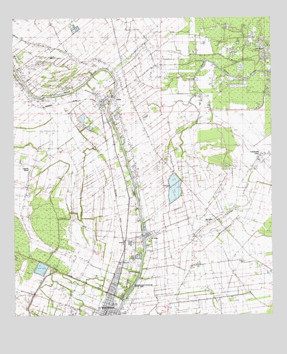
Parks, LA USGS Topographic Map
Click on map above to begin viewing in our Map Viewer.

This topographic map contains these locations and features:
Feature Name Type Latitude Longitude GNIS ID View Map
Ace Flying AirportAirportN30.2346°W91.8311°2676765View Map
Azema (historical)Populated PlaceN30.2246°W91.8729°551493View Map
Banker PlantationPopulated PlaceN30.1355°W91.7801°559819View Map
Bayou MartinStreamN30.2341°W91.7546°560026View Map
Castille FieldAirportN30.2426°W91.8691°2676783View Map
City of Saint MartinvilleCivilN30.1264°W91.8319°2405397View Map
Cypress Island CouleeStreamN30.2041°W91.8396°560572View Map
Cypress Island Coulee CanalCanalN30.1402°W91.8440°560573View Map
East Saint Martinville Gas FieldOilfieldN30.1416°W91.7743°551518View Map
First United Pentecostal ChurchChurchN30.1318°W91.8361°2602000View Map
Gary Landing Strip Ultralight FlightparkAirportN30.2202°W91.8344°1632907View Map
Gauthier (historical)Populated PlaceN30.1952°W91.8296°551525View Map
Isle LabbePopulated PlaceN30.1655°W91.7765°1627333View Map
KDEA-FM (New Iberia)TowerN30.2013°W91.7759°1632475View Map
Kingdom Hall of Jehovahs WitnessesChurchN30.1306°W91.8522°2602138View Map
KTDY-FM (Lafayette)TowerN30.2013°W91.7759°1632454View Map
La Pointe School (historical)SchoolN30.2185°W91.8676°551532View Map
Lake MartinLakeN30.2337°W91.7539°1627616View Map
LevertPopulated PlaceN30.1571°W91.8212°1627476View Map
Longfellow-Evangeline State Historic SiteParkN30.1377°W91.8173°1627565View Map
Louisiana Noname 44 DamDamN30.1735°W91.7984°1628793View Map
Louisiana Noname 45 DamDamN30.1452°W91.8618°1628794View Map
North Side ParkParkN30.1396°W91.8221°551539View Map
Parish Governing Authority District 3CivilN30.1492°W91.8096°1929976View Map
ParksPopulated PlaceN30.2144°W91.8321°1627871View Map
Parks Middle SchoolSchoolN30.2128°W91.8236°2493331View Map
Parks Police DepartmentBuildingN30.2139°W91.8334°2334114View Map
Parks Primary SchoolSchoolN30.2154°W91.8331°551540View Map
Parks Station (historical)LocaleN30.2213°W91.8201°551541View Map
Parks Volunteer Fire DepartmentBuildingN30.2141°W91.8330°2332376View Map
Parks Wastewater Treatment FacilityLocaleN30.2111°W91.8340°2603490View Map
Saint JohnPopulated PlaceN30.1588°W91.8087°1628124View Map
Saint Martin Parish Industrial ParkLocaleN30.1548°W91.8188°2599997View Map
Saint Martin Parish Industrial Park Wastewater Treatment FacilityLocaleN30.1505°W91.8154°2603506View Map
Saint Martin Parish Juvenile Center Alternative SchoolSchoolN30.1351°W91.8644°2493501View Map
Saint Martin Parish Library Parks BranchBuildingN30.2142°W91.8336°2603132View Map
Saint Martin Parish Police Jury Sub BarnBuildingN30.1467°W91.8395°2334112View Map
Saint MartinvillePopulated PlaceN30.1252°W91.8334°1630009View Map
Saint Martinville Oil and Gas FieldOilfieldN30.1441°W91.8471°1628139View Map
Saint Martinville Primary SchoolSchoolN30.1299°W91.8265°551554View Map
Saint Martinville Rehabilitation and Nursing CenterBuildingN30.1446°W91.8221°2601125View Map
Saint Martinville Senior High SchoolSchoolN30.1313°W91.8264°551555View Map
Section 28 Oil and Gas FieldOilfieldN30.2327°W91.7718°1628199View Map
Skyview Ranch Airport (historical)AirportN30.2108°W91.8648°1632906View Map
Village of ParksCivilN30.2172°W91.8272°2407520View Map
Ward ThreeCivilN30.1852°W91.7976°1628612View Map

Note: Coordinates in the location and feature list above are referenced to NAD83 datum.


Copyright (C) 2008-2024 Ryan Niemi / Sunset Dynamics ... All Rights Reserved