TopoQuest Logo
Do you find TopoQuest useful?
Help keep TopoQuest running and adding new maps/features by donating!
Bitcoin:  19c7KJd3qBynnjoSw5npx9KScwjBe4ifkT
Litecoin:  LXs6TkuXGGXo1vDsWCkWVdjQX94eUKd6ui
Home View Maps Find Maps Find Places Resources & Links


Catahoula, Louisiana Topographic Map

USGS Map Title: Catahoula, LA
USGS Map MRC: 30091B6
DRG (GeoTIFF) Download: o30091b6.tif


Neighboring USGS Topographic Map Quads:


  Cecilia, LA  
30091C7
 

  Butte La Rose, LA  
30091C6
 

  Cow Bayou, LA  
30091C5
 

  Parks, LA  
30091B7
 

  Catahoula, LA  
30091B6


  New Iberia North, LA  
30091A7


Map MRC Location:

N31°
W92°
N31°
W91°
H8 H7 H6 H5 H4 H3 H2 H1
G8 G7 G6 G5 G4 G3 G2 G1
F8 F7 F6 F5 F4 F3 F2 F1
E8 E7 E6 E5 E4 E3 E2 E1
D8 D7 D6 D5 D4 D3 D2 D1
C8 C7 C6 C5 C4 C3 C2 C1
B8 B7 B6 B5 B4 B3 B2 B1
A8 A7 A6 A5 A4 A3 A2 A1
N30°
W92°
N30°
W91°

Catahoula, LA USGS 1:24K Topographic Map Preview:
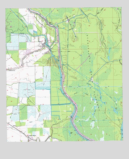
Catahoula, LA USGS Topographic Map
Click on map above to begin viewing in our Map Viewer.

This topographic map contains these locations and features:
Feature Name Type Latitude Longitude GNIS ID View Map
BankersPopulated PlaceN30.1394°W91.7426°559820View Map
Bay BaronLakeN30.1426°W91.6559°559836View Map
Bay ToniLakeN30.1606°W91.6644°559844View Map
Bayou GarotierStreamN30.2430°W91.6629°559960View Map
Bayou JunctionStreamN30.2260°W91.7240°559990View Map
Bayou La Rose Gas FieldOilfieldN30.2099°W91.6793°551496View Map
Bayou MersierGutN30.2277°W91.6965°551535View Map
Bayou VeillonStreamN30.1663°W91.7037°560101View Map
CatahoulaPopulated PlaceN30.2146°W91.7090°560374View Map
Catahoula Census Designated PlaceCensusN30.2125°W91.7127°2586672View Map
Catahoula CouleeStreamN30.2160°W91.7071°560375View Map
Catahoula CovePopulated PlaceN30.1935°W91.7462°560376View Map
Catahoula Elementary SchoolSchoolN30.2167°W91.7105°551504View Map
Catahoula LakeLakeN30.2091°W91.7016°560377View Map
Catahoula Lake Fire DepartmentBuildingN30.2101°W91.7177°2332565View Map
Coteau HolmesPopulated PlaceN30.1299°W91.7262°560475View Map
Coteau Holmes Volunteer Fire DepartmentBuildingN30.1280°W91.7273°2332470View Map
Crocodile BayouStreamN30.1374°W91.6268°560534View Map
Crocodile Bayou Oil FieldOilfieldN30.1752°W91.6598°551510View Map
Cypress BrakeSwampN30.1587°W91.6622°551512View Map
Grand CouleeStreamN30.1694°W91.6493°560870View Map
Haha BayLakeN30.1531°W91.6328°560926View Map
Indian Mound CemeteryCemeteryN30.2419°W91.6584°551529View Map
Lake La RoseLakeN30.2458°W91.6671°1627414View Map
Lake La Rose Gas FieldOilfieldN30.2410°W91.6818°1627434View Map
Our Lady of the Lake CemeteryCemeteryN30.2088°W91.7065°1627844View Map
Parish Governing Authority District 4CivilN30.1385°W91.6474°1930035View Map
Parish Governing Authority District 5CivilN30.2447°W91.6686°1930100View Map
Saint Isabel ChurchChurchN30.1266°W91.7209°551546View Map
Sandy's Trailer ParkPopulated PlaceN30.1268°W91.7254°2600901View Map
Willow LakeLakeN30.1335°W91.6827°1628513View Map

Note: Coordinates in the location and feature list above are referenced to NAD83 datum.


Copyright (C) 2008-2025 Ryan Niemi / Sunset Dynamics ... All Rights Reserved