TopoQuest Logo
Do you find TopoQuest useful?
Help keep TopoQuest running and adding new maps/features by donating!
Bitcoin:  19c7KJd3qBynnjoSw5npx9KScwjBe4ifkT
Litecoin:  LXs6TkuXGGXo1vDsWCkWVdjQX94eUKd6ui
Home View Maps Find Maps Find Places Resources & Links


Butte La Rose, Louisiana Topographic Map

USGS Map Title: Butte La Rose, LA
USGS Map MRC: 30091C6
DRG (GeoTIFF) Download: o30091c6.tif


Neighboring USGS Topographic Map Quads:


  Portage, LA  
30091D7
 

  Maringouin NW, LA  
30091D6
 

  Maringouin, LA  
30091D5
 

  Cecilia, LA  
30091C7
 

  Butte La Rose, LA  
30091C6
 

  Cow Bayou, LA  
30091C5
 

  Parks, LA  
30091B7
 

  Catahoula, LA  
30091B6


Map MRC Location:

N31°
W92°
N31°
W91°
H8 H7 H6 H5 H4 H3 H2 H1
G8 G7 G6 G5 G4 G3 G2 G1
F8 F7 F6 F5 F4 F3 F2 F1
E8 E7 E6 E5 E4 E3 E2 E1
D8 D7 D6 D5 D4 D3 D2 D1
C8 C7 C6 C5 C4 C3 C2 C1
B8 B7 B6 B5 B4 B3 B2 B1
A8 A7 A6 A5 A4 A3 A2 A1
N30°
W92°
N30°
W91°

Butte La Rose, LA USGS 1:24K Topographic Map Preview:
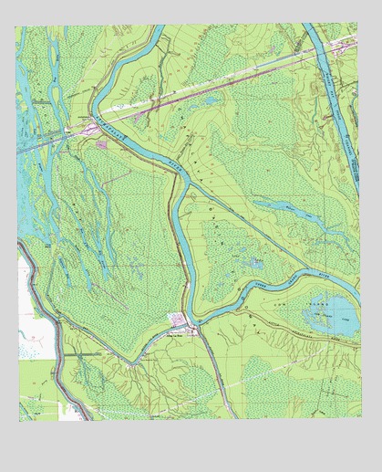
Butte La Rose, LA USGS Topographic Map
Click on map above to begin viewing in our Map Viewer.

This topographic map contains these locations and features:
Feature Name Type Latitude Longitude GNIS ID View Map
AtchafalayaPopulated PlaceN30.3460°W91.7232°559795View Map
Atchafalaya RiverStreamN30.2846°W91.6721°559801View Map
Atchasalauga Acres Mobile Home ParkPopulated PlaceN30.2822°W91.6915°2600379View Map
Bay A'BotBayN30.3080°W91.7259°559835View Map
Bay FarineBayN30.3016°W91.7196°559840View Map
Bay HahaBayN30.3608°W91.7357°559841View Map
Bay SiriusSwampN30.2551°W91.6442°559843View Map
Bayou Berard CanalCanalN30.2521°W91.7476°559868View Map
Bayou La RoseStreamN30.2796°W91.6846°559998View Map
Bayou LoinStreamN30.3083°W91.7337°560007View Map
Bayou MalboeufStreamN30.3441°W91.6984°560018View Map
Bayou PerryStreamN30.2633°W91.7384°560045View Map
Begnard BayLakeN30.2977°W91.7328°560133View Map
Butte La RosePopulated PlaceN30.2777°W91.6868°560309View Map
Butte La Rose BayStreamN30.3016°W91.7373°560310View Map
Butte La Rose CemeteryCemeteryN30.2810°W91.6807°551503View Map
Butte La Rose CutoffCanalN30.3124°W91.6671°560311View Map
Butte Larose Volunteer Fire DepartmentBuildingN30.2782°W91.6868°2332702View Map
Cow IslandIslandN30.2852°W91.6465°560508View Map
Cow Island LakeLakeN30.2833°W91.6372°560511View Map
Crusel (historical)Populated PlaceN30.3552°W91.6765°551511View Map
Davis Roadside ParkParkN30.2696°W91.7062°560595View Map
Des Ours Mill (historical)LocaleN30.3563°W91.6754°551516View Map
Five PointCapeN30.3060°W91.7373°560754View Map
Gin SloughStreamN30.3396°W91.7321°560830View Map
Interchange 121CrossingN30.3433°W91.7215°1628659View Map
Interchange 127CrossingN30.3669°W91.6337°541398View Map
Lake PelbaLakeN30.3582°W91.7355°551542View Map
Little Bayou Des OursesStreamN30.3302°W91.6901°1627496View Map
Lost LakeLakeN30.3005°W91.6671°1627568View Map
Opelousas BaySwampN30.3291°W91.7346°1627839View Map
PelbaPopulated PlaceN30.3419°W91.7326°555615View Map
Warner LakeLakeN30.3144°W91.6463°1628441View Map

Note: Coordinates in the location and feature list above are referenced to NAD83 datum.


Copyright (C) 2008-2024 Ryan Niemi / Sunset Dynamics ... All Rights Reserved