TopoQuest Logo
Do you find TopoQuest useful?
Help keep TopoQuest running and adding new maps/features by donating!
Bitcoin:  19c7KJd3qBynnjoSw5npx9KScwjBe4ifkT
Litecoin:  LXs6TkuXGGXo1vDsWCkWVdjQX94eUKd6ui
Home View Maps Find Maps Find Places Resources & Links


Parnell East, Missouri Topographic Map

USGS Map Title: Parnell East, MO
USGS Map MRC: 40094D5
DRG (GeoTIFF) Download: o40094d5.tif


Neighboring USGS Topographic Map Quads:


  Bedford SW, MO  
40094E6
 

  Sheridan, MO  
40094E5
 

  Blockton, IA  
40094E4
 

  Parnell West, MO  
40094D6
 

  Parnell East, MO  
40094D5
 

  Grant City, MO  
40094D4
 

  Ravenwood, MO  
40094C6
 

  Alanthus Grove, MO  
40094C5
 

  Gentry, MO  
40094C4


Map MRC Location:

N41°
W95°
N41°
W94°
H8 H7 H6 H5 H4 H3 H2 H1
G8 G7 G6 G5 G4 G3 G2 G1
F8 F7 F6 F5 F4 F3 F2 F1
E8 E7 E6 E5 E4 E3 E2 E1
D8 D7 D6 D5 D4 D3 D2 D1
C8 C7 C6 C5 C4 C3 C2 C1
B8 B7 B6 B5 B4 B3 B2 B1
A8 A7 A6 A5 A4 A3 A2 A1
N40°
W95°
N40°
W94°

Parnell East, MO USGS 1:24K Topographic Map Preview:
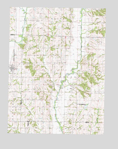
Parnell East, MO USGS Topographic Map
Click on map above to begin viewing in our Map Viewer.

This topographic map contains these locations and features:
Feature Name Type Latitude Longitude GNIS ID View Map
Batson School (historical)SchoolN40.4564°W94.5364°713736View Map
Bethel ChurchChurchN40.4864°W94.5036°714080View Map
Champion Hill School (historical)SchoolN40.4019°W94.6241°715714View Map
City of ParnellCivilN40.4386°W94.6218°2396157View Map
Concord School (historical)SchoolN40.4022°W94.5350°716185View Map
Echo Dell School (historical)SchoolN40.4858°W94.5261°717390View Map
Grandview School (historical)SchoolN40.4717°W94.5614°718689View Map
Miller School (historical)SchoolN40.4380°W94.5669°722395View Map
Mount Evart School (historical)SchoolN40.4605°W94.5900°722748View Map
Mount Vernon ChurchChurchN40.4669°W94.5055°722914View Map
Mount Zion SchoolSchoolN40.4094°W94.5850°722982View Map
OxfordPopulated PlaceN40.4211°W94.5405°730172View Map
ParnellPopulated PlaceN40.4400°W94.6233°724051View Map
Parnell CemeteryCemeteryN40.4276°W94.6220°2702582View Map
Parnell Elementary SchoolSchoolN40.4396°W94.6181°2545096View Map
Parnell Fire Protection DistrictBuildingN40.4398°W94.6228°2621206View Map
Parnell Post OfficePost OfficeN40.4386°W94.6206°2782669View Map
Platte River Tributaries Watershed Dam 7-BDamN40.4900°W94.5969°760667View Map
Ponder DamDamN40.4333°W94.6152°761098View Map
Ponder LakeReservoirN40.4333°W94.6152°761099View Map
Township of GreeneCivilN40.4293°W94.5440°767541View Map
Watkins CemeteryCemeteryN40.3789°W94.5097°728417View Map
Worth 8-B LakeReservoirN40.4900°W94.5942°760668View Map
Worth County Community LakeReservoirN40.4019°W94.5246°760481View Map
Worth County Community Lake DamDamN40.4017°W94.5269°760480View Map
Worth County Community Lake State Recreation AreaLocaleN40.4019°W94.5250°741739View Map
X BranchStreamN40.4172°W94.5608°729180View Map

Note: Coordinates in the location and feature list above are referenced to NAD83 datum.


Copyright (C) 2008-2025 Ryan Niemi / Sunset Dynamics ... All Rights Reserved