TopoQuest Logo
Do you find TopoQuest useful?
Help keep TopoQuest running and adding new maps/features by donating!
Bitcoin:  19c7KJd3qBynnjoSw5npx9KScwjBe4ifkT
Litecoin:  LXs6TkuXGGXo1vDsWCkWVdjQX94eUKd6ui
Home View Maps Find Maps Find Places Resources & Links


Pat Mayse Lake West, Texas Topographic Map

USGS Map Title: Pat Mayse Lake West, TX
USGS Map MRC: 33095G6
DRG (GeoTIFF) Download: o33095g6.tif


Neighboring USGS Topographic Map Quads:


  New Oberlin, OK  
33095H7
 

  Bluff, OK  
33095H6
 

  Grant, OK  
33095H5
 

  Direct, TX  
33095G7
 

  Pat Mayse Lake West, TX  
33095G6
 

  Pat Mayse Lake East, TX  
33095G5
 

  Tigertown, TX  
33095F7
 

  Toco, TX  
33095F6
 

  Paris, TX  
33095F5


Map MRC Location:

N34°
W96°
N34°
W95°
H8 H7 H6 H5 H4 H3 H2 H1
G8 G7 G6 G5 G4 G3 G2 G1
F8 F7 F6 F5 F4 F3 F2 F1
E8 E7 E6 E5 E4 E3 E2 E1
D8 D7 D6 D5 D4 D3 D2 D1
C8 C7 C6 C5 C4 C3 C2 C1
B8 B7 B6 B5 B4 B3 B2 B1
A8 A7 A6 A5 A4 A3 A2 A1
N33°
W96°
N33°
W95°

Pat Mayse Lake West, TX USGS 1:24K Topographic Map Preview:
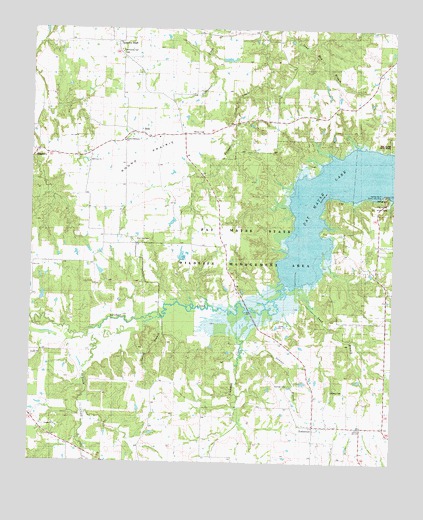
Pat Mayse Lake West, TX USGS Topographic Map
Click on map above to begin viewing in our Map Viewer.

This topographic map contains these locations and features:
Feature Name Type Latitude Longitude GNIS ID View Map
BelkPopulated PlaceN33.8451°W95.7150°1351817View Map
Bibleway ChurchChurchN33.8365°W95.7305°1889860View Map
Campbell LakeReservoirN33.8018°W95.7219°1864559View Map
Campbell Lake DamDamN33.8018°W95.7219°1864558View Map
Caviness CemeteryCemeteryN33.7712°W95.6469°1354022View Map
Community Hall CemeteryCemeteryN33.8670°W95.7197°1889859View Map
Craddock CreekStreamN33.7934°W95.6736°1355299View Map
Craddock SchoolSchoolN33.7729°W95.7002°1355300View Map
Davis SchoolSchoolN33.8537°W95.6461°1355718View Map
EmbersonPopulated PlaceN33.7609°W95.6525°1357001View Map
Garretts BluffPopulated PlaceN33.8715°W95.7208°1357907View Map
Lamar PointCapeN33.8273°W95.6289°1889862View Map
Lamar Point Volunteer Fire Department Station 1BuildingN33.8115°W95.6301°2655630View Map
Little CreekStreamN33.7868°W95.7302°1361323View Map
Parson FieldAirportN33.8564°W95.7033°2676625View Map
Pat Mayse State Park 1ParkN33.8420°W95.6286°1889861View Map
Pat Mayse State Park 2ParkN33.8243°W95.6291°1889863View Map
Post Oak CemeteryCemeteryN33.8140°W95.7150°1782060View Map
Post Oak SchoolSchoolN33.8137°W95.7152°1365666View Map
RagtownPopulated PlaceN33.8393°W95.7477°1382589View Map
Round PrairieFlatN33.8359°W95.7180°1366964View Map
Sand BranchStreamN33.8009°W95.6630°1367565View Map
Spring BranchStreamN33.7918°W95.7058°1368940View Map
Summer BranchStreamN33.7823°W95.6761°1369382View Map
Sumner CemeteryCemeteryN33.7724°W95.6606°1369391View Map
Sumner DivisionCivilN33.7733°W95.7139°1939241View Map
United Methodist ChurchChurchN33.8426°W95.7183°1890010View Map
Willow LakeReservoirN33.7951°W95.7136°1864561View Map
Willow Lake DamDamN33.7951°W95.7136°1864560View Map

Note: Coordinates in the location and feature list above are referenced to NAD83 datum.


Copyright (C) 2008-2025 Ryan Niemi / Sunset Dynamics ... All Rights Reserved