TopoQuest Logo
Do you find TopoQuest useful?
Help keep TopoQuest running and adding new maps/features by donating!
Bitcoin:  19c7KJd3qBynnjoSw5npx9KScwjBe4ifkT
Litecoin:  LXs6TkuXGGXo1vDsWCkWVdjQX94eUKd6ui
Home View Maps Find Maps Find Places Resources & Links


Grant, Oklahoma Topographic Map

USGS Map Title: Grant, OK
USGS Map MRC: 33095H5
DRG (GeoTIFF) Download: o33095h5.tif


Neighboring USGS Topographic Map Quads:


  Soper, OK  
34095A6
 

  Hugo, OK  
34095A5
 

  Hugo Dam, OK  
34095A4
 

  Bluff, OK  
33095H6
 

  Grant, OK  
33095H5
 

  Shoals, OK  
33095H4
 

  Pat Mayse Lake West, TX  
33095G6
 

  Pat Mayse Lake East, TX  
33095G5
 

  Slate Shoals, TX  
33095G4


Map MRC Location:

N34°
W96°
N34°
W95°
H8 H7 H6 H5 H4 H3 H2 H1
G8 G7 G6 G5 G4 G3 G2 G1
F8 F7 F6 F5 F4 F3 F2 F1
E8 E7 E6 E5 E4 E3 E2 E1
D8 D7 D6 D5 D4 D3 D2 D1
C8 C7 C6 C5 C4 C3 C2 C1
B8 B7 B6 B5 B4 B3 B2 B1
A8 A7 A6 A5 A4 A3 A2 A1
N33°
W96°
N33°
W95°

Grant, OK USGS 1:24K Topographic Map Preview:
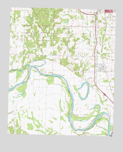
Grant, OK USGS Topographic Map
Click on map above to begin viewing in our Map Viewer.

This topographic map contains these locations and features:
Feature Name Type Latitude Longitude GNIS ID View Map
Allen IslandIslandN33.8854°W95.5405°1089586View Map
Antioch ChurchChurchN33.9532°W95.6091°1089653View Map
Boggy CutoffChannelN33.9487°W95.5869°1090346View Map
Cold Springs ChurchChurchN33.9743°W95.6044°1091558View Map
Crosley CemeteryCemeteryN33.9856°W95.5125°1777504View Map
GayPopulated PlaceN33.9534°W95.6214°1093152View Map
Gay CemeteryCemeteryN33.9540°W95.5912°2723906View Map
Gay SchoolSchoolN33.9612°W95.6216°1093153View Map
Gay SchoolSchoolN33.9832°W95.6050°1093154View Map
GoodlandPopulated PlaceN33.9818°W95.5552°1101883View Map
Goodland AcademySchoolN33.9800°W95.5582°2712890View Map
Goodland CemeteryCemeteryN33.9835°W95.5599°1093252View Map
Goodland Elementary SchoolSchoolN33.9799°W95.5566°1093253View Map
GrantPopulated PlaceN33.9432°W95.5136°1093317View Map
Grant Census Designated PlaceCensusN33.9387°W95.5156°2629920View Map
Grant Elementary SchoolSchoolN33.9439°W95.5136°1790666View Map
Grant Post OfficePost OfficeN33.9435°W95.5142°1814267View Map
Grant Volunteer Fire DepartmentBuildingN33.9410°W95.5117°2657097View Map
Grassy LakeLakeN33.9073°W95.6061°1358316View Map
Hanubby CreekStreamN33.9398°W95.6075°1093515View Map
Heathcock BranchStreamN33.9615°W95.5883°1089492View Map
Horse Prairie ChurchChurchN33.9212°W95.5030°1777502View Map
Hugo Elementary SchoolSchoolN33.9962°W95.5007°1793723View Map
Mount Olive CemeteryCemeteryN33.9678°W95.5185°1095580View Map
Mount Olive CemeteryCemeteryN33.9865°W95.5122°1095581View Map
Mount Olive ChurchChurchN33.9523°W95.5136°1095585View Map
Mount Olivet CemeteryCemeteryN33.9979°W95.5025°1777506View Map
Mount Pleasant ChurchChurchN33.9590°W95.5558°1777507View Map
Muddy Boggy CreekStreamN33.9379°W95.6111°1095686View Map
Pitts BendBendN33.8993°W95.5380°1096694View Map
Roebuck LakeLakeN33.9112°W95.5364°1097388View Map
Sanders CreekStreamN33.8807°W95.5063°1383180View Map
Southside Baptist ChurchChurchN33.9987°W95.5080°1798375View Map
Springs CemeteryCemeteryN33.9909°W95.5113°1098460View Map
Springs ChapelChurchN33.9829°W95.5036°1777503View Map
Springs Chapel CemeteryCemeteryN33.9918°W95.5113°1777505View Map
Springs Family CemeteryCemeteryN33.9939°W95.5040°2770117View Map
Sweet Hill CemeteryCemeteryN33.9499°W95.5738°1098685View Map

Note: Coordinates in the location and feature list above are referenced to NAD83 datum.


Copyright (C) 2008-2025 Ryan Niemi / Sunset Dynamics ... All Rights Reserved