TopoQuest Logo
Do you find TopoQuest useful?
Help keep TopoQuest running and adding new maps/features by donating!
Bitcoin:  19c7KJd3qBynnjoSw5npx9KScwjBe4ifkT
Litecoin:  LXs6TkuXGGXo1vDsWCkWVdjQX94eUKd6ui
Home View Maps Find Maps Find Places Resources & Links


Pateville, Georgia Topographic Map

USGS Map Title: Pateville, GA
USGS Map MRC: 31083G7
DRG (GeoTIFF) Download: o31083g7.tif


Neighboring USGS Topographic Map Quads:


  Cobb, GA  
31083H8
 

  Cordele, GA  
31083H7
 

  Penia, GA  
31083H6
 

  Warwick, GA  
31083G8
 

  Pateville, GA  
31083G7
 

  Arabi, GA  
31083G6
 

  Doles, GA  
31083F8
 

  Cuffietown, GA  
31083F7
 

  Ashburn, GA  
31083F6


Map MRC Location:

N32°
W84°
N32°
W83°
H8 H7 H6 H5 H4 H3 H2 H1
G8 G7 G6 G5 G4 G3 G2 G1
F8 F7 F6 F5 F4 F3 F2 F1
E8 E7 E6 E5 E4 E3 E2 E1
D8 D7 D6 D5 D4 D3 D2 D1
C8 C7 C6 C5 C4 C3 C2 C1
B8 B7 B6 B5 B4 B3 B2 B1
A8 A7 A6 A5 A4 A3 A2 A1
N31°
W84°
N31°
W83°

Pateville, GA USGS 1:24K Topographic Map Preview:
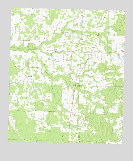
Pateville, GA USGS Topographic Map
Click on map above to begin viewing in our Map Viewer.

This topographic map contains these locations and features:
Feature Name Type Latitude Longitude GNIS ID View Map
Acorn PondPopulated PlaceN31.8105°W83.8552°330998View Map
Acorn Pond Missionary Baptist ChurchChurchN31.8107°W83.8549°343248View Map
Antioch Missionary Baptist ChurchChurchN31.8543°W83.8157°354333View Map
BridgesPopulated PlaceN31.8530°W83.8652°334961View Map
Bridges School (historical)SchoolN31.8532°W83.8657°334963View Map
Bryant Store (historical)LocaleN31.7807°W83.8063°343263View Map
Butts CemeteryCemeteryN31.8007°W83.8652°343266View Map
Cabb Chapel (historical)ChurchN31.8632°W83.8271°334975View Map
County Line BridgeBridgeN31.8038°W83.8027°343270View Map
Davis ChapelChurchN31.8324°W83.8313°313343View Map
HardinPopulated PlaceN31.8543°W83.8166°335001View Map
Hardin LakeReservoirN31.8349°W83.8202°340963View Map
Hardin Lake DamDamN31.8352°W83.8232°340962View Map
Hopewell School (historical)SchoolN31.7768°W83.7693°343211View Map
Houston Youth CampLocaleN31.8366°W83.8493°315747View Map
Lebanon ChurchChurchN31.8521°W83.8168°316717View Map
Mckinney LakeReservoirN31.7958°W83.7529°342127View Map
Mckinney Lake DamDamN31.7968°W83.7549°342126View Map
Moore LakeReservoirN31.8314°W83.7642°340961View Map
Moore Lake DamDamN31.8302°W83.7632°340960View Map
Mount Olive ChurchChurchN31.8041°W83.8657°318739View Map
Mount Olive School (historical)SchoolN31.8002°W83.8652°343312View Map
New Hope SchoolSchoolN31.7952°W83.8741°319380View Map
North Branch Swift CreekStreamN31.8402°W83.8516°319637View Map
PatevillePopulated PlaceN31.8360°W83.8238°332617View Map
Pateville Community CenterBuildingN31.8363°W83.8255°335024View Map
Primrose BridgeBridgeN31.8391°W83.8543°321145View Map
Primrose Church (historical)ChurchN31.8418°W83.8552°335026View Map
Rattlesnake BranchStreamN31.8218°W83.8396°321319View Map
Rocky Mount CemeteryCemeteryN31.7510°W83.7877°349379View Map
Rocky Mount ChurchChurchN31.7521°W83.7877°321852View Map
Saint James ChurchChurchN31.8516°W83.7966°322080View Map
Saint James School (historical)SchoolN31.8355°W83.7902°335030View Map
Story-Odum CemeteryCemeteryN31.7993°W83.8466°323659View Map
Vickers School (historical)SchoolN31.7718°W83.8091°343357View Map
White Store (historical)LocaleN31.7627°W83.8152°343361View Map
Zion Hope CemeteryCemeteryN31.8529°W83.8154°325706View Map

Note: Coordinates in the location and feature list above are referenced to NAD83 datum.


Copyright (C) 2008-2024 Ryan Niemi / Sunset Dynamics ... All Rights Reserved