TopoQuest Logo
Do you find TopoQuest useful?
Help keep TopoQuest running and adding new maps/features by donating!
Bitcoin:  19c7KJd3qBynnjoSw5npx9KScwjBe4ifkT
Litecoin:  LXs6TkuXGGXo1vDsWCkWVdjQX94eUKd6ui
Home View Maps Find Maps Find Places Resources & Links


Pawnee, Louisiana Topographic Map

USGS Map Title: Pawnee, LA
USGS Map MRC: 30092H6
DRG (GeoTIFF) Download: o30092h6.tif


Neighboring USGS Topographic Map Quads:


  Afeman, LA  
31092A7
 

  Melder, LA  
31092A6
 

  Forest Hill, LA  
31092A5
 

  Steep Gully, LA  
30092H7
 

  Pawnee, LA  
30092H6
 

  Glenmora, LA  
30092H5
 

  Elizabeth, LA  
30092G7
 

  Oakdale, LA  
30092G6
 

  Beaver, LA  
30092G5


Map MRC Location:

N31°
W93°
N31°
W92°
H8 H7 H6 H5 H4 H3 H2 H1
G8 G7 G6 G5 G4 G3 G2 G1
F8 F7 F6 F5 F4 F3 F2 F1
E8 E7 E6 E5 E4 E3 E2 E1
D8 D7 D6 D5 D4 D3 D2 D1
C8 C7 C6 C5 C4 C3 C2 C1
B8 B7 B6 B5 B4 B3 B2 B1
A8 A7 A6 A5 A4 A3 A2 A1
N30°
W93°
N30°
W92°

Pawnee, LA USGS 1:24K Topographic Map Preview:
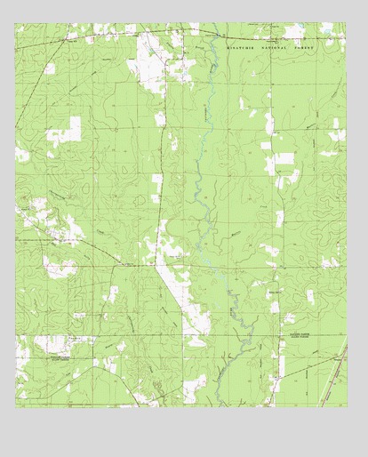
Pawnee, LA USGS Topographic Map
Click on map above to begin viewing in our Map Viewer.

This topographic map contains these locations and features:
Feature Name Type Latitude Longitude GNIS ID View Map
Bad GullyStreamN30.9157°W92.7088°546991View Map
Bethany ChurchChurchN30.9124°W92.6513°547058View Map
BethelPopulated PlaceN30.9219°W92.7096°551817View Map
Bethel CemeteryCemeteryN30.9399°W92.7438°551818View Map
Bethel ChurchChurchN30.9219°W92.7088°547060View Map
Calcasieu ChurchChurchN30.9969°W92.7040°547163View Map
Cow BayouStreamN30.8966°W92.7051°547253View Map
Davis Crossing ChurchChurchN30.9944°W92.6515°547293View Map
Gospel ChurchChurchN30.9991°W92.6538°547410View Map
Hickory Grove School (historical)SchoolN30.9946°W92.6488°551845View Map
Hope Well ChurchChurchN30.8980°W92.7296°547474View Map
Hopewell Baptist ChurchChurchN30.8981°W92.7298°2601924View Map
Humble ChurchChurchN30.9402°W92.7446°547488View Map
Masters CreekStreamN30.9205°W92.6746°547656View Map
Melder CemeteryCemeteryN30.9996°W92.6585°547679View Map
OsburnPopulated PlaceN30.9213°W92.6976°551862View Map
Osburn Willis CemeteryCemeteryN30.9244°W92.6879°547803View Map
PawneePopulated PlaceN30.8905°W92.6271°547821View Map
Plainview Community Volunteer Fire DepartmentBuildingN30.9950°W92.7306°2672945View Map
Prairie BranchStreamN30.9910°W92.6760°547867View Map
Spring Creek Volunteer Fire Department Station 1BuildingN30.9948°W92.6293°2672934View Map
Union HillPopulated PlaceN30.9946°W92.7313°548108View Map
Union Hill School (historical)SchoolN30.9963°W92.7299°551878View Map
Walnut Grove School (historical)SchoolN30.9191°W92.6526°551879View Map

Note: Coordinates in the location and feature list above are referenced to NAD83 datum.


Copyright (C) 2008-2024 Ryan Niemi / Sunset Dynamics ... All Rights Reserved