TopoQuest Logo
Do you find TopoQuest useful?
Help keep TopoQuest running and adding new maps/features by donating!
Bitcoin:  19c7KJd3qBynnjoSw5npx9KScwjBe4ifkT
Litecoin:  LXs6TkuXGGXo1vDsWCkWVdjQX94eUKd6ui
Home View Maps Find Maps Find Places Resources & Links


Melder, Louisiana Topographic Map

USGS Map Title: Melder, LA
USGS Map MRC: 31092A6
DRG (GeoTIFF) Download: o31092a6.tif


Neighboring USGS Topographic Map Quads:


  Sieper, LA  
31092B7
 

  Elmer, LA  
31092B6
 

  Woodworth West, LA  
31092B5
 

  Afeman, LA  
31092A7
 

  Melder, LA  
31092A6
 

  Forest Hill, LA  
31092A5
 

  Steep Gully, LA  
30092H7
 

  Pawnee, LA  
30092H6
 

  Glenmora, LA  
30092H5


Map MRC Location:

N32°
W93°
N32°
W92°
H8 H7 H6 H5 H4 H3 H2 H1
G8 G7 G6 G5 G4 G3 G2 G1
F8 F7 F6 F5 F4 F3 F2 F1
E8 E7 E6 E5 E4 E3 E2 E1
D8 D7 D6 D5 D4 D3 D2 D1
C8 C7 C6 C5 C4 C3 C2 C1
B8 B7 B6 B5 B4 B3 B2 B1
A8 A7 A6 A5 A4 A3 A2 A1
N31°
W93°
N31°
W92°

Melder, LA USGS 1:24K Topographic Map Preview:
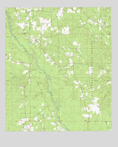
Melder, LA USGS Topographic Map
Click on map above to begin viewing in our Map Viewer.

This topographic map contains these locations and features:
Feature Name Type Latitude Longitude GNIS ID View Map
Bill CreekStreamN31.1207°W92.6671°547087View Map
Blounts CreekStreamN31.0630°W92.7096°547104View Map
Buck CreekStreamN31.0971°W92.7426°547143View Map
CalcasieuPopulated PlaceN31.0896°W92.7115°553855View Map
Camp Ground Church (historical)ChurchN31.0516°W92.6271°551680View Map
Campground CemeteryCemeteryN31.0510°W92.6268°548230View Map
ElmelhinePopulated PlaceN31.1157°W92.6901°551704View Map
Goodman BranchStreamN31.0932°W92.7374°547405View Map
Lemeuse CreekStreamN31.0527°W92.6990°547572View Map
Lone Star CemeteryCemeteryN31.0693°W92.7310°551732View Map
Lone Star ChurchChurchN31.0732°W92.7454°547622View Map
Lone Star School (historical)SchoolN31.0738°W92.7449°551733View Map
MelderPopulated PlaceN31.1052°W92.6365°547678View Map
Melder Post OfficePost OfficeN31.1074°W92.6371°1631754View Map
New Hope ChurchChurchN31.0921°W92.7099°551745View Map
Oak Grove ChurchChurchN31.1205°W92.7226°547782View Map
Oak Grove School (historical)SchoolN31.1230°W92.7282°551748View Map
Oak Hill Volunteer Fire Department Station 1BuildingN31.1209°W92.7220°2672907View Map
Padget BranchStreamN31.1010°W92.7440°547811View Map
Palustris Experimental Forest Longleaf TractParkN31.0252°W92.6293°548251View Map
Peniel ChurchChurchN31.0727°W92.6760°547826View Map
Pine Ridge Baptist ChurchChurchN31.1074°W92.6369°2602587View Map
Pisgah Church (historical)ChurchN31.0032°W92.7293°551760View Map
Rocky BranchStreamN31.0924°W92.6276°547904View Map
Rooty BranchStreamN31.0552°W92.7385°547913View Map
Saint Mark CemeteryCemeteryN31.1163°W92.6329°547931View Map
Saint Mark ChurchChurchN31.1227°W92.6318°547932View Map
Saint Mark School (historical)SchoolN31.1221°W92.6313°551776View Map
Sandy BranchStreamN31.0430°W92.7001°547959View Map
Shady Grove School (historical)SchoolN31.0641°W92.6815°551781View Map
Spring Creek Volunteer Fire Department Station 2BuildingN31.0739°W92.6750°2673128View Map
Squyres BranchStreamN31.0991°W92.6410°548029View Map
Stanley CemeteryCemeteryN31.0485°W92.7115°548032View Map
Sunset Lookout TowerTowerN31.0338°W92.6574°558831View Map
Union Hill CemeteryCemeteryN31.0066°W92.7268°548109View Map
Union Hill ChurchChurchN31.0021°W92.7288°548110View Map

Note: Coordinates in the location and feature list above are referenced to NAD83 datum.


Copyright (C) 2008-2025 Ryan Niemi / Sunset Dynamics ... All Rights Reserved