TopoQuest Logo
Do you find TopoQuest useful?
Help keep TopoQuest running and adding new maps/features by donating!
Bitcoin:  19c7KJd3qBynnjoSw5npx9KScwjBe4ifkT
Litecoin:  LXs6TkuXGGXo1vDsWCkWVdjQX94eUKd6ui
Home View Maps Find Maps Find Places Resources & Links


Steep Gully, Louisiana Topographic Map

USGS Map Title: Steep Gully, LA
USGS Map MRC: 30092H7
DRG (GeoTIFF) Download: o30092h7.tif


Neighboring USGS Topographic Map Quads:


  Fullerton Lake, LA  
31092A8
 

  Afeman, LA  
31092A7
 

  Melder, LA  
31092A6
 

  Pitkin, LA  
30092H8
 

  Steep Gully, LA  
30092H7
 

  Pawnee, LA  
30092H6
 

  Grant, LA  
30092G8
 

  Elizabeth, LA  
30092G7
 

  Oakdale, LA  
30092G6


Map MRC Location:

N31°
W93°
N31°
W92°
H8 H7 H6 H5 H4 H3 H2 H1
G8 G7 G6 G5 G4 G3 G2 G1
F8 F7 F6 F5 F4 F3 F2 F1
E8 E7 E6 E5 E4 E3 E2 E1
D8 D7 D6 D5 D4 D3 D2 D1
C8 C7 C6 C5 C4 C3 C2 C1
B8 B7 B6 B5 B4 B3 B2 B1
A8 A7 A6 A5 A4 A3 A2 A1
N30°
W93°
N30°
W92°

Steep Gully, LA USGS 1:24K Topographic Map Preview:
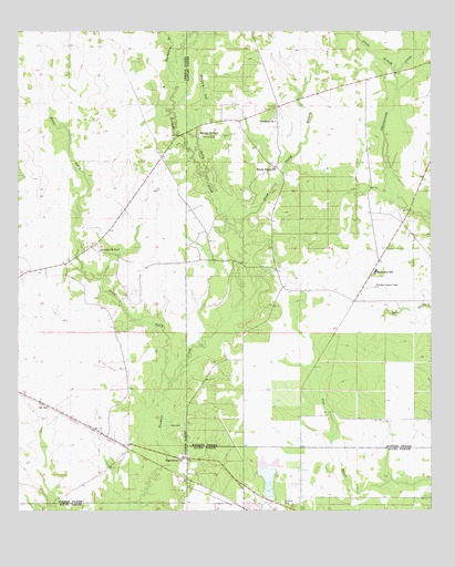
Steep Gully, LA USGS Topographic Map
Click on map above to begin viewing in our Map Viewer.

This topographic map contains these locations and features:
Feature Name Type Latitude Longitude GNIS ID View Map
Community Volunteer Fire DepartmentBuildingN30.9396°W92.8412°2673000View Map
Elizabeth CemeteryCemeteryN30.8771°W92.7951°534790View Map
Freedom Baptist ChurchChurchN30.9766°W92.7972°2602010View Map
Freedom ChurchChurchN30.9769°W92.7974°535096View Map
Friendship Baptist ChurchChurchN30.9752°W92.8072°2602017View Map
Hickory Log GullyStreamN30.9619°W92.8182°535654View Map
Humble Baptist ChurchChurchN30.9539°W92.8201°2601939View Map
Louisiana Noname 61 DamDamN30.8785°W92.7985°556917View Map
Mainview SchoolSchoolN30.9377°W92.7671°536857View Map
Occupy Church Number 1ChurchN30.9735°W92.8210°537810View Map
Occupy Church Number 2ChurchN30.9432°W92.8504°537811View Map
Occupy School (historical)SchoolN30.9646°W92.7979°551860View Map
Ocupi Church (historical)ChurchN30.9663°W92.8004°551861View Map
Pine Grove ChurchChurchN30.8888°W92.8257°538171View Map
Plainview High SchoolSchoolN30.9375°W92.7667°551865View Map
Plainview Lookout TowerTowerN30.9335°W92.7671°558812View Map
Refuge School (historical)SchoolN30.9530°W92.7674°551869View Map
Shady Grove Baptist ChurchChurchN30.9642°W92.7972°2602800View Map
Shady Grove ChurchChurchN30.9644°W92.7976°539275View Map
Steep GullyStreamN30.9091°W92.8288°539651View Map
Steep Gully BranchStreamN30.9480°W92.8079°539652View Map
Swetz BranchStreamN30.9896°W92.7615°548058View Map
Tenmile CemeteryCemeteryN30.9727°W92.8201°556216View Map
Thompson BranchStreamN30.9899°W92.8296°548076View Map
West CemeteryCemeteryN30.8971°W92.8260°540305View Map
WestportPopulated PlaceN30.9646°W92.7974°551881View Map

Note: Coordinates in the location and feature list above are referenced to NAD83 datum.


Copyright (C) 2008-2025 Ryan Niemi / Sunset Dynamics ... All Rights Reserved