TopoQuest Logo
Do you find TopoQuest useful?
Help keep TopoQuest running and adding new maps/features by donating!
Bitcoin:  19c7KJd3qBynnjoSw5npx9KScwjBe4ifkT
Litecoin:  LXs6TkuXGGXo1vDsWCkWVdjQX94eUKd6ui
Home View Maps Find Maps Find Places Resources & Links


Paxville, South Carolina Topographic Map

USGS Map Title: Paxville, SC
USGS Map MRC: 33080F3
DRG (GeoTIFF) Download: o33080f3.tif


Neighboring USGS Topographic Map Quads:


  Privateer, SC  
33080G4
 

  Brogdon, SC  
33080G3
 

  Tearcoat Branch, SC  
33080G2
 

  Pinewood, SC  
33080F4
 

  Paxville, SC  
33080F3
 

  Manning, SC  
33080F2
 

  Saint Paul, SC  
33080E4
 

  Summerton, SC  
33080E3
 

  Jordan, SC  
33080E2


Map MRC Location:

N34°
W81°
N34°
W80°
H8 H7 H6 H5 H4 H3 H2 H1
G8 G7 G6 G5 G4 G3 G2 G1
F8 F7 F6 F5 F4 F3 F2 F1
E8 E7 E6 E5 E4 E3 E2 E1
D8 D7 D6 D5 D4 D3 D2 D1
C8 C7 C6 C5 C4 C3 C2 C1
B8 B7 B6 B5 B4 B3 B2 B1
A8 A7 A6 A5 A4 A3 A2 A1
N33°
W81°
N33°
W80°

Paxville, SC USGS 1:24K Topographic Map Preview:
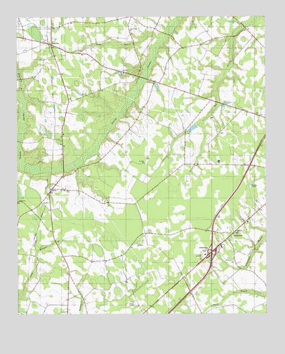
Paxville, SC USGS Topographic Map
Click on map above to begin viewing in our Map Viewer.

This topographic map contains these locations and features:
Feature Name Type Latitude Longitude GNIS ID View Map
Barrett church (historical)ChurchN33.6877°W80.2862°1235879View Map
Berry PondReservoirN33.7031°W80.2866°1240032View Map
Berry Pond Dam D-3491DamN33.7052°W80.2848°1240031View Map
Broadway BranchStreamN33.7193°W80.3729°1220095View Map
Chapel Hill Church (historical)ChurchN33.6979°W80.3526°1235900View Map
Clarendon County Rural Fire Department PaxvilleBuildingN33.7388°W80.3584°2368224View Map
Delain Chapel (historical)ChurchN33.7413°W80.2709°1235910View Map
Eden Street School (historical)SchoolN33.7177°W80.2862°1235922View Map
Edna Ward PondReservoirN33.7137°W80.2685°1240020View Map
Edna Ward Pond Dam D-3492DamN33.7135°W80.2698°1240019View Map
Elizabeth ChurchChurchN33.6599°W80.2648°1222262View Map
Friendship ChurchChurchN33.6718°W80.3626°1222573View Map
Gumspring ChurchChurchN33.6549°W80.3148°1222955View Map
HalleytownPopulated PlaceN33.6585°W80.2667°1227912View Map
Halleytown Church (historical)ChurchN33.6602°W80.2654°1235940View Map
Halleytown School (historical)SchoolN33.6596°W80.2645°1248753View Map
Home BranchStreamN33.7416°W80.3015°1223259View Map
Home Branch CemeteryCemeteryN33.7440°W80.3173°1235946View Map
Home Branch ChurchChurchN33.7443°W80.3181°1246033View Map
Hungary Hall BranchStreamN33.6868°W80.3731°1223393View Map
Interchange 115CrossingN33.6510°W80.2773°1228318View Map
Knife BranchStreamN33.6849°W80.3590°1223755View Map
Lakewood LakeReservoirN33.6552°W80.2515°1238637View Map
Mount Zero ChurchChurchN33.7266°W80.3215°1249697View Map
New Covenant Presbyterian ChurchChurchN33.6648°W80.2604°2652406View Map
New Road School (historical)SchoolN33.6877°W80.2865°1235979View Map
Oak Grove School (historical)SchoolN33.6963°W80.3520°1235987View Map
PaxvillePopulated PlaceN33.7388°W80.3573°1250042View Map
Paxville Post OfficePost OfficeN33.7383°W80.3577°2489871View Map
Paxville School (historical)SchoolN33.7396°W80.3631°1248760View Map
Rambay ChurchChurchN33.6566°W80.3156°1235999View Map
Rambay School (historical)SchoolN33.6496°W80.3231°1236000View Map
Rosehen BaySwampN33.6694°W80.2964°1236007View Map
Rosehen BranchStreamN33.6877°W80.3445°1236008View Map
Saint John School (historical)SchoolN33.6885°W80.3351°1236013View Map
Saint John School (historical)SchoolN33.7002°W80.3220°1236014View Map
Saint Johns ChurchChurchN33.6888°W80.3112°1250544View Map
Saint Mark Missionary Baptist ChurchChurchN33.6724°W80.3745°1250591View Map
Saint Marys School (historical)SchoolN33.7413°W80.3220°1236019View Map
SilverPopulated PlaceN33.6779°W80.3573°1226615View Map
Silver School (historical)SchoolN33.6779°W80.3520°1236034View Map
South Carolina Highway PatrolBuildingN33.6654°W80.2572°2334921View Map
South Carolina Noname 14012 D-3499 DamDamN33.6552°W80.2515°1238636View Map
Summerton Lookout TowerTowerN33.6293°W80.3184°1236047View Map
Town of PaxvilleCivilN33.7390°W80.3586°2407084View Map
W J Jackson PondReservoirN33.7385°W80.3165°1240036View Map
W J Jackson Pond Dam D-3488DamN33.7385°W80.3165°1240035View Map
Wildcat BranchStreamN33.6502°W80.3656°1227591View Map
WYMB-AM (Manning)TowerN33.6902°W80.2729°1252385View Map
Zoar Hill School (historical)SchoolN33.6335°W80.2842°1236072View Map

Note: Coordinates in the location and feature list above are referenced to NAD83 datum.


Copyright (C) 2008-2025 Ryan Niemi / Sunset Dynamics ... All Rights Reserved