TopoQuest Logo
Do you find TopoQuest useful?
Help keep TopoQuest running and adding new maps/features by donating!
Bitcoin:  19c7KJd3qBynnjoSw5npx9KScwjBe4ifkT
Litecoin:  LXs6TkuXGGXo1vDsWCkWVdjQX94eUKd6ui
Home View Maps Find Maps Find Places Resources & Links


Tearcoat Branch, South Carolina Topographic Map

USGS Map Title: Tearcoat Branch, SC
USGS Map MRC: 33080G2
DRG (GeoTIFF) Download: o33080g2.tif


Neighboring USGS Topographic Map Quads:


  Sumter East, SC  
33080H3
 

  Mayesville, SC  
33080H2
 

  Turbeville, SC  
33080H1
 

  Brogdon, SC  
33080G3
 

  Tearcoat Branch, SC  
33080G2
 

  Sardinia, SC  
33080G1
 

  Paxville, SC  
33080F3
 

  Manning, SC  
33080F2
 

  Foreston, SC  
33080F1


Map MRC Location:

N34°
W81°
N34°
W80°
H8 H7 H6 H5 H4 H3 H2 H1
G8 G7 G6 G5 G4 G3 G2 G1
F8 F7 F6 F5 F4 F3 F2 F1
E8 E7 E6 E5 E4 E3 E2 E1
D8 D7 D6 D5 D4 D3 D2 D1
C8 C7 C6 C5 C4 C3 C2 C1
B8 B7 B6 B5 B4 B3 B2 B1
A8 A7 A6 A5 A4 A3 A2 A1
N33°
W81°
N33°
W80°

Tearcoat Branch, SC USGS 1:24K Topographic Map Preview:
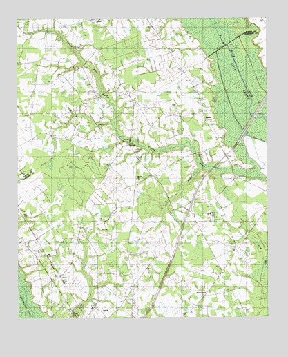
Tearcoat Branch, SC USGS Topographic Map
Click on map above to begin viewing in our Map Viewer.

This topographic map contains these locations and features:
Feature Name Type Latitude Longitude GNIS ID View Map
AlcoluPopulated PlaceN33.7510°W80.2142°1230998View Map
Alcolu Census Designated PlaceCensusN33.7547°W80.2221°2629817View Map
Alcolu DivisionCivilN33.7697°W80.1577°1938183View Map
Alcolu Elementary SchoolSchoolN33.7543°W80.2131°1235877View Map
Alcolu Post OfficePost OfficeN33.7504°W80.2171°2489769View Map
Alderman PondReservoirN33.8018°W80.1681°1240038View Map
Alderman Pond Dam D-3486DamN33.8018°W80.1681°1240037View Map
Black River SwampSwampN33.8423°W80.1429°1220776View Map
Brunsons CemeteryCemeteryN33.8632°W80.2173°1244473View Map
Congruity ChurchChurchN33.8749°W80.2095°1244499View Map
Congruity School (historical)SchoolN33.8749°W80.2092°1244500View Map
Crow BaySwampN33.7814°W80.1312°1221858View Map
Cuttinumber PondReservoirN33.8168°W80.1965°1240044View Map
Cuttinumber Pond Dam D-3482DamN33.8168°W80.1965°1240043View Map
Davis BranchStreamN33.8310°W80.2012°1235908View Map
DurantPopulated PlaceN33.8299°W80.1542°1231249View Map
Enterprise SchoolSchoolN33.8265°W80.1523°1222298View Map
Green Hill ChurchChurchN33.7529°W80.2079°1235936View Map
Harmony ChurchChurchN33.7782°W80.1404°1223047View Map
HarvinPopulated PlaceN33.7671°W80.2284°1223076View Map
Harvin SchoolSchoolN33.7752°W80.2404°1223078View Map
Mount Milian ChurchChurchN33.8279°W80.1929°1235974View Map
Mount Nebo ChurchChurchN33.8082°W80.1901°1235975View Map
Mount Nero School (historical)SchoolN33.8082°W80.1898°1251788View Map
Mount Olive School (historical)SchoolN33.7668°W80.1887°1235976View Map
New Harmony ChurchChurchN33.7932°W80.1534°1245910View Map
Oak Grove ChurchChurchN33.7721°W80.1448°1225103View Map
Pen BranchStreamN33.8135°W80.1570°1227859View Map
Pleasant Grove ChurchChurchN33.7607°W80.1556°1235995View Map
Pleasant Grove School (historical)SchoolN33.7607°W80.1556°1235996View Map
Reevesville ChurchChurchN33.7779°W80.2390°1236001View Map
Reevesville School (historical)SchoolN33.7777°W80.2387°1236002View Map
Sumter Southeast DivisionCivilN33.8681°W80.2486°1938437View Map
Tearcoat BranchStreamN33.8093°W80.1326°1251133View Map
Westminister ChurchChurchN33.8221°W80.1934°1251397View Map
Westminister School (historical)SchoolN33.8221°W80.1945°1251790View Map

Note: Coordinates in the location and feature list above are referenced to NAD83 datum.


Copyright (C) 2008-2025 Ryan Niemi / Sunset Dynamics ... All Rights Reserved