TopoQuest Logo
Do you find TopoQuest useful?
Help keep TopoQuest running and adding new maps/features by donating!
Bitcoin:  19c7KJd3qBynnjoSw5npx9KScwjBe4ifkT
Litecoin:  LXs6TkuXGGXo1vDsWCkWVdjQX94eUKd6ui
Home View Maps Find Maps Find Places Resources & Links


Peachahala Creek, Mississippi Topographic Map

USGS Map Title: Peachahala Creek, MS
USGS Map MRC: 33089C7
DRG (GeoTIFF) Download: o33089c7.tif


Neighboring USGS Topographic Map Quads:


  Coila, MS  
33089D8
 

  Bailey Lake, MS  
33089D7
 

  Winona, MS  
33089D6
 

  Murdock Lake, MS  
33089C8
 

  Peachahala Creek, MS  
33089C7
 

  Vaiden, MS  
33089C6
 

  Bowling Green, MS  
33089B8
 

  West, MS  
33089B7
 

  Hesterville, MS  
33089B6


Map MRC Location:

N34°
W90°
N34°
W89°
H8 H7 H6 H5 H4 H3 H2 H1
G8 G7 G6 G5 G4 G3 G2 G1
F8 F7 F6 F5 F4 F3 F2 F1
E8 E7 E6 E5 E4 E3 E2 E1
D8 D7 D6 D5 D4 D3 D2 D1
C8 C7 C6 C5 C4 C3 C2 C1
B8 B7 B6 B5 B4 B3 B2 B1
A8 A7 A6 A5 A4 A3 A2 A1
N33°
W90°
N33°
W89°

Peachahala Creek, MS USGS 1:24K Topographic Map Preview:
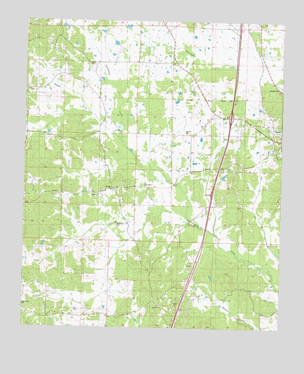
Peachahala Creek, MS USGS Topographic Map
Click on map above to begin viewing in our Map Viewer.

This topographic map contains these locations and features:
Feature Name Type Latitude Longitude GNIS ID View Map
Carroll - Montgomery County / Regional Correctional FacilityBuildingN33.3373°W89.7724°2739794View Map
Hagger CreekStreamN33.3273°W89.8284°670820View Map
Hairston CemeteryCemeteryN33.3068°W89.8323°670824View Map
Hopewell CemeteryCemeteryN33.3296°W89.7962°671409View Map
Interchange 174CrossingN33.3362°W89.7751°691446View Map
Lively Stone ChurchChurchN33.3079°W89.8162°672730View Map
McEachern CemeteryCemeteryN33.2921°W89.8298°673342View Map
Midway CemeteryCemeteryN33.3032°W89.8392°1805856View Map
Midway ChurchChurchN33.3035°W89.8390°673551View Map
Midway ChurchChurchN33.3046°W89.8584°673552View Map
Mitchell's AirportAirportN33.3021°W89.8142°2676374View Map
Mount Zion ChurchChurchN33.3576°W89.8434°674381View Map
Self CreekStreamN33.2954°W89.7956°677504View Map
Shiloh CemeteryCemeteryN33.2597°W89.8017°677666View Map
Shiloh ChurchChurchN33.2582°W89.8087°677692View Map
Shongalo (historical)LocaleN33.3279°W89.7542°684925View Map
Supervisor District 5CivilN33.3056°W89.7658°711797View Map
Town of VaidenCivilN33.3332°W89.7534°2406783View Map
WiltshirePopulated PlaceN33.3046°W89.8568°684935View Map

Note: Coordinates in the location and feature list above are referenced to NAD83 datum.


Copyright (C) 2008-2025 Ryan Niemi / Sunset Dynamics ... All Rights Reserved