TopoQuest Logo
Do you find TopoQuest useful?
Help keep TopoQuest running and adding new maps/features by donating!
Bitcoin:  19c7KJd3qBynnjoSw5npx9KScwjBe4ifkT
Litecoin:  LXs6TkuXGGXo1vDsWCkWVdjQX94eUKd6ui
Home View Maps Find Maps Find Places Resources & Links


Coila, Mississippi Topographic Map

USGS Map Title: Coila, MS
USGS Map MRC: 33089D8
DRG (GeoTIFF) Download: o33089d8.tif


Neighboring USGS Topographic Map Quads:


  Browning, MS  
33090E1
 

  North Carrollton, MS  
33089E8
 

  McCarley, MS  
33089E7
 

  Gravel Hill, MS  
33090D1
 

  Coila, MS  
33089D8
 

  Bailey Lake, MS  
33089D7
 

  Black Hawk, MS  
33090C1
 

  Murdock Lake, MS  
33089C8
 

  Peachahala Creek, MS  
33089C7


Map MRC Location:

N34°
W90°
N34°
W89°
H8 H7 H6 H5 H4 H3 H2 H1
G8 G7 G6 G5 G4 G3 G2 G1
F8 F7 F6 F5 F4 F3 F2 F1
E8 E7 E6 E5 E4 E3 E2 E1
D8 D7 D6 D5 D4 D3 D2 D1
C8 C7 C6 C5 C4 C3 C2 C1
B8 B7 B6 B5 B4 B3 B2 B1
A8 A7 A6 A5 A4 A3 A2 A1
N33°
W90°
N33°
W89°

Coila, MS USGS 1:24K Topographic Map Preview:
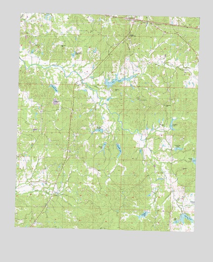
Coila, MS USGS Topographic Map
Click on map above to begin viewing in our Map Viewer.

This topographic map contains these locations and features:
Feature Name Type Latitude Longitude GNIS ID View Map
Ashley CreekStreamN33.4582°W89.9515°666398View Map
Burkhead LakeReservoirN33.3844°W89.9104°667812View Map
Carpenter LakeReservoirN33.4233°W89.8877°668085View Map
Carroll CountyCivilN33.4485°W89.9202°695732View Map
Carrollton Lookout TowerTowerN33.4885°W89.9237°711213View Map
CoilaPopulated PlaceN33.3954°W89.9712°668644View Map
Coila CemeteryCemeteryN33.4010°W89.9806°668645View Map
Coila Post OfficePost OfficeN33.3888°W89.9787°2768842View Map
Costilow LakeReservoirN33.4371°W89.8923°668846View Map
Enon CemeteryCemeteryN33.3940°W89.8870°1959794View Map
Enon ChurchChurchN33.3937°W89.8870°669788View Map
Foreman CemeteryCemeteryN33.4559°W89.9326°670084View Map
Gee LakeReservoirN33.4618°W89.9315°670347View Map
Gilmore LakeReservoirN33.4567°W89.9752°670402View Map
Marshall CemeteryCemeteryN33.4365°W89.8981°673162View Map
Morgan LakeReservoirN33.4326°W89.9433°673810View Map
Oak Grove CemeteryCemeteryN33.4812°W89.9715°675014View Map
Pelucia Creek Structure Y-33a-26 DamDamN33.4218°W89.9134°682070View Map
Pelucia Creek Structure Y-33a-28 DamDamN33.4135°W89.8967°682062View Map
Pelucia Creek Structure Y-33a-39 DamDamN33.4518°W89.9351°682098View Map
Pelucia Watershed Y-33a-1 DamDamN33.4601°W89.9384°682105View Map
Pelucia Watershed Y-33a-10 DamDamN33.4268°W89.9351°682076View Map
Pelucia Watershed Y-33a-11 DamDamN33.4335°W89.9368°682077View Map
Pelucia Watershed Y-33a-12 DamDamN33.4618°W89.9751°682107View Map
Pelucia Watershed Y-33a-13 DamDamN33.4785°W89.9617°682129View Map
Pelucia Watershed Y-33a-2 DamDamN33.4368°W89.8901°682082View Map
Pelucia Watershed Y-33a-25a DamDamN33.4801°W89.9451°682133View Map
Pelucia Watershed Y-33a-3 DamDamN33.4235°W89.8834°682073View Map
Pelucia Watershed Y-33a-4 DamDamN33.4235°W89.8834°682072View Map
Pelucia Watershed Y-33a-6 DamDamN33.3851°W89.8834°682039View Map
Pelucia Watershed Y-33a-7 DamDamN33.3868°W89.8951°682044View Map
Pelucia Watershed Y-33a-8 DamDamN33.3901°W89.9068°682050View Map
Pelucia Watershed Y-33a-9 DamDamN33.4268°W89.9301°682075View Map
Phillips LakeReservoirN33.4232°W89.9394°675693View Map
Poplar Springs ChurchChurchN33.4507°W89.9156°676243View Map
Shackelford LakeReservoirN33.4766°W89.9622°677537View Map
Shelton LakeReservoirN33.4219°W89.9287°677646View Map
Spring LakeReservoirN33.3830°W89.8809°678152View Map
Springhill ChurchChurchN33.4112°W89.8842°678184View Map
Stansberry CemeteryCemeteryN33.4479°W89.8970°678221View Map
Upper LakeReservoirN33.3808°W89.8876°679151View Map

Note: Coordinates in the location and feature list above are referenced to NAD83 datum.


Copyright (C) 2008-2025 Ryan Niemi / Sunset Dynamics ... All Rights Reserved