TopoQuest Logo
Do you find TopoQuest useful?
Help keep TopoQuest running and adding new maps/features by donating!
Bitcoin:  19c7KJd3qBynnjoSw5npx9KScwjBe4ifkT
Litecoin:  LXs6TkuXGGXo1vDsWCkWVdjQX94eUKd6ui
Home View Maps Find Maps Find Places Resources & Links


Pearson, Oklahoma Topographic Map

USGS Map Title: Pearson, OK
USGS Map MRC: 35096A8
DRG (GeoTIFF) Download: o35096a8.tif


Neighboring USGS Topographic Map Quads:


  Macomb, OK  
35097B1
 

  Brooksville, OK  
35096B8
 

  Maud, OK  
35096B7
 

  Tribbey, OK  
35097A1
 

  Pearson, OK  
35096A8
 

  Saint Louis, OK  
35096A7
 

  Wanette, OK  
34097H1
 

  Asher, OK  
34096H8
 

  Konawa, OK  
34096H7


Map MRC Location:

N36°
W97°
N36°
W96°
H8 H7 H6 H5 H4 H3 H2 H1
G8 G7 G6 G5 G4 G3 G2 G1
F8 F7 F6 F5 F4 F3 F2 F1
E8 E7 E6 E5 E4 E3 E2 E1
D8 D7 D6 D5 D4 D3 D2 D1
C8 C7 C6 C5 C4 C3 C2 C1
B8 B7 B6 B5 B4 B3 B2 B1
A8 A7 A6 A5 A4 A3 A2 A1
N35°
W97°
N35°
W96°

Pearson, OK USGS 1:24K Topographic Map Preview:
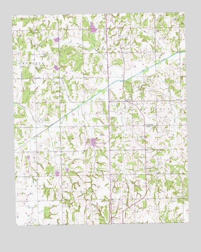
Pearson, OK USGS Topographic Map
Click on map above to begin viewing in our Map Viewer.

This topographic map contains these locations and features:
Feature Name Type Latitude Longitude GNIS ID View Map
AndersonPopulated PlaceN35.0873°W96.9845°1100176View Map
Anderson SchoolSchoolN35.0937°W96.9839°1089631View Map
AvocaPopulated PlaceN35.0140°W96.9306°1100185View Map
Avoca CemeteryCemeteryN35.0148°W96.9483°1089772View Map
Blacksmith CreekStreamN35.0940°W96.8967°1090235View Map
Box CreekStreamN35.1001°W96.8836°1090434View Map
Cloverdale SchoolSchoolN35.0587°W96.9056°1091488View Map
Cottonwood CreekStreamN35.0590°W96.9745°1091727View Map
Delaware CreekStreamN35.0709°W96.9525°1092030View Map
East Cottonwood CreekStreamN35.0729°W96.9961°1092382View Map
Light CemeteryCemeteryN35.0730°W96.9161°2708667View Map
Louis Oil FieldOilfieldN35.0701°W96.8970°1095018View Map
Macomb Fire Department Station 2BuildingN35.1003°W96.9832°2657384View Map
Oak Grove CemeteryCemeteryN35.0578°W96.8994°2708671View Map
Oak Grove ChurchChurchN35.0579°W96.8997°1096146View Map
Opossum CreekStreamN35.0854°W96.9225°1096293View Map
PearsonPopulated PlaceN35.0729°W96.9178°1096506View Map
RomulusPopulated PlaceN35.1165°W96.9234°1100799View Map
Romulus CemeteryCemeteryN35.1159°W96.9308°1097405View Map
Salt Creek Site 1 DamDamN35.1134°W96.9420°1751997View Map
Salt Creek Site 1 ReservoirReservoirN35.1168°W96.9419°1751998View Map
Salt Creek Site 2 DamDamN35.1084°W96.9670°1751999View Map
Salt Creek Site 2 ReservoirReservoirN35.1102°W96.9682°1752000View Map
Salt Creek Site 21 DamDamN35.0417°W96.9903°1752035View Map
Salt Creek Site 21 ReservoirReservoirN35.0407°W96.9904°1752036View Map
Salt Creek Site 22 DamDamN35.0351°W96.9636°1752037View Map
Salt Creek Site 22 ReservoirReservoirN35.0351°W96.9636°1752038View Map
Salt Creek Site 23 DamDamN35.0351°W96.9636°1752039View Map
Salt Creek Site 23 ReservoirReservoirN35.0351°W96.9636°1752040View Map
Salt Creek Site 24 DamDamN35.0517°W96.9436°1752041View Map
Salt Creek Site 24 ReservoirReservoirN35.0490°W96.9432°1752042View Map
Salt Creek Site 3 DamDamN35.0917°W96.9686°1752001View Map
Salt Creek Site 3 ReservoirReservoirN35.0934°W96.9687°1752002View Map
Wanette-Asher DivisionCivilN35.0096°W96.9974°1937903View Map

Note: Coordinates in the location and feature list above are referenced to NAD83 datum.


Copyright (C) 2008-2025 Ryan Niemi / Sunset Dynamics ... All Rights Reserved