TopoQuest Logo
Do you find TopoQuest useful?
Help keep TopoQuest running and adding new maps/features by donating!
Bitcoin:  19c7KJd3qBynnjoSw5npx9KScwjBe4ifkT
Litecoin:  LXs6TkuXGGXo1vDsWCkWVdjQX94eUKd6ui
Home View Maps Find Maps Find Places Resources & Links


Wanette, Oklahoma Topographic Map

USGS Map Title: Wanette, OK
USGS Map MRC: 34097H1
DRG (GeoTIFF) Download: o34097h1.tif


Neighboring USGS Topographic Map Quads:


  Eason, OK  
35097A2
 

  Tribbey, OK  
35097A1
 

  Pearson, OK  
35096A8
 

  Rosedale, OK  
34097H2
 

  Wanette, OK  
34097H1
 

  Asher, OK  
34096H8
 

  Byars SW, OK  
34097G2
 

  Byars, OK  
34097G1
 

  Stratford, OK  
34096G8


Map MRC Location:

N35°
W98°
N35°
W97°
H8 H7 H6 H5 H4 H3 H2 H1
G8 G7 G6 G5 G4 G3 G2 G1
F8 F7 F6 F5 F4 F3 F2 F1
E8 E7 E6 E5 E4 E3 E2 E1
D8 D7 D6 D5 D4 D3 D2 D1
C8 C7 C6 C5 C4 C3 C2 C1
B8 B7 B6 B5 B4 B3 B2 B1
A8 A7 A6 A5 A4 A3 A2 A1
N34°
W98°
N34°
W97°

Wanette, OK USGS 1:24K Topographic Map Preview:
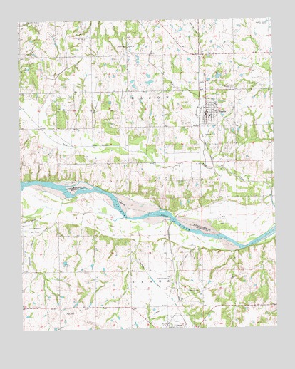
Wanette, OK USGS Topographic Map
Click on map above to begin viewing in our Map Viewer.

This topographic map contains these locations and features:
Feature Name Type Latitude Longitude GNIS ID View Map
Canadian Sandy CreekStreamN34.9287°W97.1025°1090894View Map
East McClain DivisionCivilN34.8957°W97.1066°1937698View Map
East Rosedale Oil FieldOilfieldN34.9159°W97.1186°1092434View Map
Gallup Ranch DamDamN34.9034°W97.0903°1754218View Map
Gallup Ranch ReservoirReservoirN34.9034°W97.0903°1754219View Map
Hog CreekStreamN34.9401°W97.0336°1093819View Map
JohnsonvillePopulated PlaceN34.8956°W97.0536°1100540View Map
Martin Hill CemeteryCemeteryN34.9999°W97.1157°1095163View Map
New Johnsonville CemeteryCemeteryN34.8909°W97.0453°1095827View Map
Northeast Crossroads Oil FieldOilfieldN34.9917°W97.0934°1096022View Map
Northwest Wanette Oil FieldOilfieldN34.9881°W97.0711°1096060View Map
Old Johnsonville CemeteryCemeteryN34.8950°W97.0517°2724102View Map
Pitts Field (historical)AirportN34.9895°W97.0256°1102728View Map
South Wanette Oil FieldOilfieldN34.9037°W97.0431°1098283View Map
Town of WanetteCivilN34.9626°W97.0319°2413446View Map
Township of ByarsCivilN34.8917°W97.0614°1824741View Map
Township of EasonCivilN34.9917°W97.0586°1824937View Map
WanettePopulated PlaceN34.9620°W97.0325°1099348View Map
Wanette CemeteryCemeteryN34.9720°W97.0200°1099349View Map
Wanette Elementary SchoolSchoolN34.9658°W97.0284°1819449View Map
Wanette High SchoolSchoolN34.9664°W97.0285°1819448View Map
Wanette Oil FieldOilfieldN34.9470°W97.0217°1099350View Map
Wanette Volunteer Fire Department Station 1BuildingN34.9619°W97.0327°2657379View Map
West Wanette Oil FieldOilfieldN34.9665°W97.0872°1099618View Map

Note: Coordinates in the location and feature list above are referenced to NAD83 datum.


Copyright (C) 2008-2025 Ryan Niemi / Sunset Dynamics ... All Rights Reserved